I FINALLY GOT A RESERVATION ON THE LAKE O’HARA BUS!!! Following years of futility, I had nearly given up on even trying to take the bus up to Lake O’Hara. With a daily quota of only 42 bus seats for day use visitors, access to this pristine area of the Rockies is extremely limited. Of course, anyone wanting to visit Lake O’Hara is welcome to hike or ski up the dull 11 km access road but this option is much less appealing than a 20 minute bus ride. Twice before, I’ve been the person hurriedly hiking up the road as the daily buses motor by with ease. If you ever want to feel utterly defeated, try hiking for 2 hours only to be passed by a bus filled with a few tourists and a half dozen empty seats! With my long-awaited bus ticket in-hand and a Friday off work, I was, therefore, ecstatic to be heading back to Lake O’Hara for a scramble; even smoky skies couldn’t dampen my spirits!
.jpg)
Postcard-worthy views of Lake O’Hara after the 20 minute butt massage (the bus ride is a tad bumpy).
.jpg)
Glacier Peak, Mount Yukness and Mount Hungabee make for a spectacular backdrop from the lake’s outlet stream. Several of the Lake O’Hara Lodge’s cabins can be seen on the opposite shore. In a future life, I plan to be fabulously wealthy so that I can afford to stay here; even if it’s just for 1 night ($920)!
.jpg)
The day’s objective: Wiwaxy Peaks as seen from the lakeshore. The west peak can be seen on the left while the multiple towers of the east peak can be seen on the right. Wiwaxy has captured my attention ever since I first saw it from the Opabin Plateau years ago so I was excited to finally give it a go!
.jpg)
The obvious turn-off for Wiwaxy Gap (and Wiwaxy East Peak) is reached after hiking along the lakeshore trail for about 5 minutes.
.jpg)
Like other Lake O’Hara trails, the Wiwaxy Gap path is brilliantly crafted and makes use of numerous ledge systems to quickly gain elevation! Some hikers may not love these airy spots but the wide open views that they provide are undeniably spectacular.
.jpg)
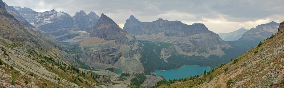
Sharp peaks pierce the sky and brilliant blue lakes dot the valley bottom as the surrounding panorama continues to improve near Wiwaxy Gap! Click to see larger.
.jpg)
Mount Huber towers over Wiwaxy Gap.
.jpg)
Located 500 meters above Lake O’Hara (right), Wiwaxy Gap is a spectacular viewpoint. After setting a brisk pace, I reached the gap in 50 minutes and enjoyed a snack break amidst the splendor shown here.
.jpg)
Looking down on the series of colorful Paternoster lakes below. From left to right: Lake Oesa, Lefroy Lake, Victoria Lake and Yukness Lake.
.jpg)
Wiwaxy Gap is the col between Wiwaxy East Peak (left) and Mount Huber (right). This high pass certainly lived up to its name as a fierce wind threatened to scatter the contents of my pack during my stop here! Perhaps this is the hanging valley that Samuel Allen referred to as “the Gorge of the Winds” in 1893? Click to see larger.
.jpg)
Studying Wiwaxy East Peak from below. It certainly looks as though the remainder of this ascent will involve some challenging scrambling!
.jpg)
After following a reasonable trail up from Wiwaxy Gap for about 10 minutes, I reached an exposed traverse. Although (mercifully) short, this was the crux of my day. After poking about for alternative routes, I reluctantly proceeded. Once across, I paused for a moment to catch my breath and noticed that my hands were shaking a little.
.jpg)
Looking back at the exposed crux traverse. Mouse over for my approximate line.
.jpg)
Beyond the crux, I clamored eagerly up loose scree (which, although unpleasant, was much easier from a psychological standpoint). After gaining as much elevation as possible on loose but easy terrain, I reached the steep wall which guards the base of Wiwaxy’s eastern towers. From here, I followed a faint trail along the wall’s base to the climber’s left (west) and around the corner (cairn).
.jpg)
Evidence that not everyone considers this to be “scrambling terrain.”
.jpg)
Once around the corner, several of the eastern summit towers are visible and several faint trails lead in several different directions. Obviously some effort goes into route finding up here! I ended up ascending the gully between the first and second towers from the right in this photo and found the terrain to be on the upper end of moderate or lower end of difficult.
.jpg)
After making my way up the gully between the summit towers, I turned my attention to the tower on the climber’s right (east) which was clearly higher than its counterpart. Although the terrain here is steep, the scrambling was very enjoyable! Mouse over to see the line that I took.
.jpg)
Success! I’m on the summit (or so I think…)!
.jpg)
Even under smoky skies, the summit panorama from Wiwaxy East Peak is outstanding. After a week of zero visibility, I was just thankful to see anything at all! From left to right: Mount Victoria, Mount Huber, Glacier Peak, Lake Oesa, Ringrose Peak, Mount Hungabee, Mount Yukness, Mount Biddle, Lake O’Hara, Mount Schaffer, Park Mountain, Mount Owen, Odaray Mountain, Wiwaxy West Peak and Mount Stephen. Click to see larger.
.jpg)
The smoke leads to a surreal glow beyond Opabin Pass and massive Mount Biddle. By now a strong afternoon wind was bringing in significant smoke from forest fires burning to the west.
.jpg)
Outstanding views towards Lake O’Hara despite the increasing smokiness. Click to see larger.
.jpg)
Dramatic lighting and an equally impressive panorama to the north. Odaray Mountain, Mount Stephen and Cathedral Mountain dominate the view to the left while Mounts Victoria and Huber tower above to the right.
.jpg)
A closer look at Mount Owen and Odaray Mountain.
.jpg)
Mount Victoria’s west face – on the other side: Alberta!
.jpg)
While I had been perfectly happy atop my summit tower, I eventually noticed that the adjacent (and easternmost) tower had a bigger summit cairn. Based on appearances alone, it was impossible to discern which was the true summit, so I grabbed my GPS and set off to investigate. Despite its intimidating appearance, the route between the 2 towers ended up being no more difficult than what I’d already climbed. Mouse over to see the line that I took.
.jpg)
Cathedral Mountain nicely framed between the two towers.
.jpg)
Success! I’m on the summit (this time for real)! My GPS readings suggested that the easternmost peak was 2 m higher than the adjacent peak which I initially climbed.
.jpg)
In addition to being marginally higher, the easternmost tower offered a less obstructed view of Lake Oesa (nestled at the base of Glacier Peak, Ringrose Peak, Mounts Hungabee and Yukness) and the Opabin Plateau (between Mounts Yukness and Biddle).
.jpg)
Looking beyond the cream-colored east towers of Wiwaxy towards the gray-colored Wiwaxy West Peak.
.jpg)
After putzing about atop the east towers, I started to cautiously descend the steep terrain. This may look intimidating but the real challenge was seeing if I could get all the way down to the lake in a little over an hour to catch the 2:30pm bus out!
.jpg)
Lake Oesa is nicely framed by a cairn during my descent.
.jpg)
Once I’d gotten back down to the crux traverse (left), I opted to shortcut straight down the gully shown here. This allowed me to bypass the crux and cut off some distance by not returning to Wiwaxy Gap. After losing about 200 vertical meters, the gully deposited me back on the well-travelled Wiwaxy Gap trail. In theory, this gully could be used to bypass the crux traverse on ascent as well but its loose nature would make this unpleasant!
.jpg)
Back on the ledgy Wiwaxy Gap trail highway!
.jpg)
As you can see, I made it back down to the lake with time to spare before the 2:30pm bus departed! Indeed, the whole descent only took me an hour. How novel to be able to catch a bus ride into and out of Lake O’Hara! A guy could get used to this!
.jpg)
.jpg)
.jpg)
.jpg)
.jpg)