With a glaciated 11,000er (Mount Sir Douglas) to one side and one of the most photogenic peaks in the Rockies (Mount Birdwood) to the other, the rolling meadows that surround Burstall Pass are among the most scenic in Kananaskis Country. Having thoroughly enjoyed this alpine Eden during the lush, green summer months, I’ve wanted to witness it in its full winter wonder for some time now (better still if I can experience it from above, atop a peak!).
Despite the fact that the popular trailhead is a short 2 hour drive from home, getting out to Burstall Pass Peak has proven to be more challenging than one would expect. The reason? Notoriously touchy weather along the nearby continental divide in this area. Indeed, on several occasions I’ve set out to snowshoe up Burstall Pass Peak only to change objectives when I noticed that the area was engulfed in cloud despite weather forecasts that suggested otherwise! A peak this pretty, after all, deserves better than whiteout weather!
.jpg)
A promising start! Clear (but FRIGID) skies above Mud Lake at the Burstall Pass trailhead.
.jpg)
How cold was it? On the drive out, my engine melted the snow on my hood but the resulting water never made it to the ground; Who else would be crazy enough to subject themselves to an outing in these conditions?...
.jpg)
Ah of course – the Crazy Pol (Raf)! Indeed, Raf even managed to convince 2 others (Nadia and Sonny) to join us (although I’m not sure that they were fully aware of what they’d signed up for).
.jpg)
Fortunately, the air was as clear as it was COLD! Although the initial 3.5 km ski up an old logging road is generally dull, occasional views of sun-splashed Mount Birdwood provided ample inspiration to continue upwards.
.jpg)
In an effort to warm the F up, I pushed my skinny ski pace and ended up a ways ahead of the group. As a result, I was “forced” to take a brief photography detour to the frozen Burstall Lakes. When I finished my shutter-bugging, I made my way back to the main trail and quickly caught back up (to the surprise of the group who thought I had been ahead the whole time).
.jpg)
Mount Sir Douglas (left) and Whistling Rock Ridge (right) appear suddenly as we leave the trees behind at the alluvial flats below the Robertson Glacier outwash.
.jpg)
Raf enjoys the panorama afforded by the wide open outwash as the sunlight slowly creeps down from the peaks towards the cold, dark valley. From left to right: Mount Sir Douglas, Whistling Rock Ridge, Snow Peak, Mount Birdwood, Pig’s Tail, Commonwealth Peak and Commonwealth Ridge. Click to see larger.
.jpg)
A closer look at beautiful Birdwood.
.jpg)
A Crazy Pol-free view of the outwash flats. Click to see larger.
.jpg)
Raf, Nadia and Sonny set out across the flats, braving a bone-chilling breeze. Although we’d seen nothing but crystal clear blue sky all morning, it appears as though Burstall Pass (behind the bump in the center of the photo) may be socked in once more.
.jpg)
After escaping from the outwash flats wind tunnel, we re-entered the trees and followed the summer trail steeply up towards subalpine meadows. The steep grade and narrow ski track through the trees proved a little much for Sonny and I and our skinny skis and we were forced to endure the “walk of shame” up with skis in hand instead of underfoot.
.jpg)
At last – trees give way to views as we near the foot of Snow Peak! Only moments after this photo was taken, a cornice on Snow Peak failed with a loud crack, sending a cloud of snow crashing down steep cliffs.
.jpg)
A sign marks the entrance to the area’s extensive alpine meadows (for now); a couple more snowfalls, however, and it will be completely buried! In the distance, a large avalanche runout from Snow Peak is obvious. Although the normal route to Burstall Pass crosses this run out, it can be avoided by staying well to the left if conditions warrant caution. This runout was, unfortunately, the site of a pair of deadly avalanche burials several years ago.
.jpg)
Commonwealth Peak provides a scenic backdrop as Nadia and Sonny make their way into the alpine.
.jpg)
The Burstall Slabs, located at the northern end of Whistling Rock Ridge, are home to several popular rock-climbing routes.
.jpg)
Burstall Pass Peak flirts with the clouds as Raf and Nadia cruise along on their fat AT skis. From here on, our route trended generally left up the draw before ascending the skyline ridge from South Burstall Pass (far left). This point also marked the end of Sonny and I’s skinny ski outing as the deep snow quickly prompted us to switch over to the snowshoes we’d packed in.
.jpg)
Sonny ascends a treed roll. It’s worth noting that even small rolls like this can slide if they’re steep enough.
.jpg)
Raf soaks up the sun as we finally leave the shade of the trees and valley behind. Meanwhile, Burstall Pass Peak appears to be the only peak in the area shrouded in cloud!
.jpg)
One of the day’s many photo ops with saber-sharp Mount Birdwood.
.jpg)
Enjoying the spectacular panorama revealed just above the tree line. Click to see larger.
.jpg)
Mount Birdwood, Pig’s Tail and Commonwealth Peak highlight the view back down our approach valley.
.jpg)
Clouds creep down along the valley along the foot of Whistling Rock Ridge.
.jpg)
Spectacular snow scenery en route to South Burstall Pass (left)! Although it’s possible to ascend Burstall Pass Peak from the north (Burstall Pass), we followed the left edge of the draw shown here to South Burstall Pass and Burstall Pass Peak’s gentler and safer south slopes.
.jpg)
Nadia skis upwards, dwarfed by Mount Birdwood, the posterchild for dogtooth mountains.
.jpg)
Views back down towards Burstall Pass at the base of Snow Peak (right).
.jpg)
Mount Assiniboine’s pointed peak appears beyond Burstall Pass.
.jpg)
Sun-kissed snow dunes sparkle underfoot as Mount Sir Douglas makes a dramatic appearance beyond South Burstall Pass.
.jpg)
Clouds pour over Burstall Pass Peak (left), run down the valley towards Snow Peak (center) and taper out before reaching Mount Birdwood (right) as Nadia and Sonny continue their grunt up the draw. Click to see larger.
.jpg)
The summit of Whistling Rock Ridge comes into view from South Burstall Pass.
.jpg)
South Burstall Pass panorama. Click to see larger.
.jpg)
Raf breaks trail up the wind-rippled south slopes of Burstall Pass Peak. Discouragingly, the high point visible here is a false summit! Although these slopes are gentler than those on the peak’s northern end, they are still steep enough to slide in places and should be treated with respect.
.jpg)
Doing what I do best – chasing a GOAT! As I crested the false summit, I startled this one and sent her scampering over the summit of Burstall Pass Peak and into the misty beyond.
.jpg)
From the false summit on, a fierce west wind nipped at any exposed skin and sent view-obscuring clouds hurtling over the peak. At least we didn’t have to break trail anymore with the goat ahead!
.jpg)
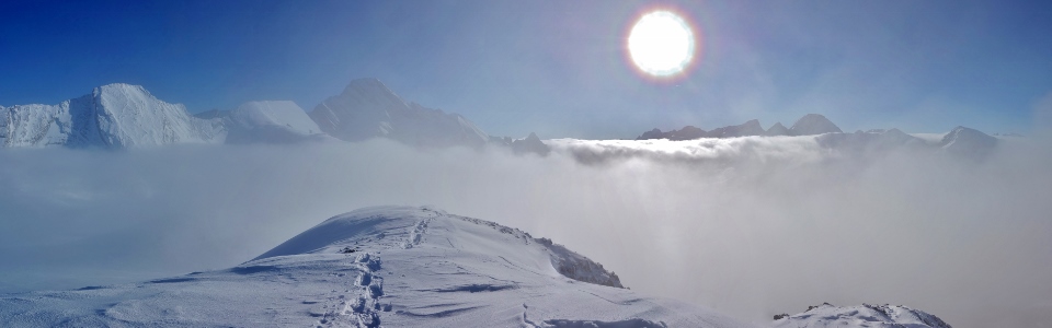
The spectacular view from the summit: the highest peaks of the continental divide float atop an ocean of cloud to the west!
.jpg)
A closer look at the peaks high enough to escape the inversion. From left to right: Mount Vavasour, Eon Mountain, Mount Warre, Mount Assiniboine, Mount Currie, Mount Magog and Mount Byng’s twin summits.
.jpg)
Sonny tops out on the summit ridge as the clouds spill up and over us once more. Although stunning, the summit views were extremely intermittent as the wicked wind whipped the clouds about.
.jpg)
Mist casts an eerie halo around the sun as Whistling Rock Ridge (left), Mount Sir Douglas (center) and the Royal Group pierce the inversion layer to the south. Click to see larger.
.jpg)
At over 11,000 feet tall, Mount Sir Douglas’ chisel-like summit remained well above the thick cloud layer.
.jpg)
Thanks to the complex and cold atmosphere on the peak, my head’s shadow was graced with a halo featuring all the colors of the rainbow. This halo is properly referred to as a “glory” and occurs as the result of a complex physical interaction between light and the water droplets in the surrounding air. If this optical phenomenon doesn’t make this photo glorious enough, surely the view back towards our approach valley will! From left to right: Mount Smuts, Mount Birdwood, Pig’s Tail, Mount Engadine, Commonwealth Peak, the Tower, Commonwealth Ridge, Mount Galatea, Gusty Peak, the Fortress and Whistling Rock Ridge.
.jpg)
On top of my 180th different summit – this one might well be the coldest that I’ve ever experienced!
.jpg)
A short-lived break in the clouds reveals a glimpse of the Spray River Valley at the base of steep cliffs to the west. High above, Mounts Back, Queen Elizabeth and King Albert make up a triad of summits on the left while Mount Leman (center) and White Man Mountain (right) bracket scarcely visible Leman Lake.
.jpg)
From left to right: Mount Leman, Sharkfin Peak, Mount Soderholm, White Man Mountain, Mount Leval and Mount Brussilof float above the sea of low-lying cloud.
.jpg)
The Frozen Four atop Burstall Pass Peak (photo courtesy Sonny Bou).
.jpg)
The spectacular winter summit panorama that numbed the pain of my freezing fingers and toes (click to see larger). As far as anesthetics go, these views proved too effective! Soon after I left the subzero summit, I realized that I’d lingered too long. Even with disposable hand and toe warmers, my digits were wooden. As the feeling slowly returned to my extremities, I was struck by a wave of nausea that forced me to recline on a snowy slope and regroup. Fortunately, my rest spot was leeward and as the “screaming barfies” subsided and feeling returned, I was able to get my descent back underway.
.jpg)
Thanks to freezing fingers, I took remarkably few photos on descent! In fact, I didn’t even think about my camera again until Sonny and I reached our skinny ski stash in the subalpine meadows below Burstall Pass.
.jpg)
The sun sets over Burstall Pass as Sonny and I start our long ski back to the car, leaving this harsh but beautiful winter wonderland behind. Our descent was definitely faster thanks to skinny skis. Even so, however, we were drained and it occasionally felt as though we were skiing uphill in both directions. If we’d brought sails, matters would have been easier as the wind continued to howl down from the pass. After a long descent, we were relieved to reach the car and even more relieved when Raf and Nadia reached their car an hour later. Burstall Pass Peak may only be a “promotory separating Burstall Pass from South Burstall Pass” but it sure was spectacular!
.jpg)
.jpg)
.jpg)
.jpg)
.jpg)
.jpg)
.jpg)