Mount Alcantara towers impressively above Marvel Pass in Mount Assiniboine Provincial Park (although the peak itself is just outside the park’s boundaries). I first laid eyes on Alcantara’s shapely form during a helicopter tour of the Canadian Rockies in 2012. I didn’t even know her name then but I was immediately smitten; call it love at first flight. After I had my feet back on the ground, I started snooping around to see what I could find out about the beauty I’d spotted across Marvel Pass. To my surprise, she seemed to keep to herself, having been with very few others! Eventually, I discovered a trip report on Andrew Nugara’s (now defunct) website from an ascent he and Raf completed in 2011. The more that I learned, the more that I wanted to be with her. I knew she wouldn’t be easy to win over (40+ km on a mining/forestry road and then hours of thick bushwhacking) but I like a challenge. And so an obsession was born. Alcantara would remain at the very top of my scrambling wish list for 4 years. During that time, I stood atop other peaks but none could compare to “Ali.”
.jpg)
The object of my desire: Mount Alcantara as seen from Marvel Pass (photo credit: Taras Kurylo). From this perspective it’s hard to imagine but the only scrambling involved in the ascent is moderate! It’s getting to the scrambling that presents the real challenge…
.jpg)
The first challenge when it comes to an attempt on Alcantara is getting to the peak which is nowhere near a major highway. Setting out from Calgary at 4am, Matt Clay and I drove his fancy new truck down Kootenay’s Highway 93 S and left the highway at the marked “Settler’s Road” exit. After following Settler’s Road for 12.4 km, we turned left (east) at a fork, crossing the Kootenay River and passing the Nipika Resort shortly thereafter. From Nipika, we followed the shockingly white forest service road, ignoring smaller roads which branched off from time to time, towards the Baymag Mine. 38 km from the Highway 93 S turnoff, we reached another fork in the road; straight ahead, the Baymag Mine was obvious across a bridge; we took the right-hand (east) branch and continued a further 3 km down the much narrower road shown here until the first bridge (which crosses Alcantara Creek). Although rougher than the main road to the Baymag Mine, this little road was still in excellent shape (the truck wasn’t necessary). As we continued along it, we were greeted with spectacular views of Mounts Aye (left) and Eon (right) bathed in early morning light. From Calgary to Alcantara Creek took just under 4 hours.
.jpg)
The moon begins to dip behind an unnamed ridge as we arrive at the trailhead.
.jpg)
We parked in a small area just off the side of the road immediately before crossing Alcantara Creek. After gearing up, we crossed the bridge (which has a few holes in it) on foot and started up along the climber’s left (north) side of the noisy creek.
.jpg)
As we followed the path of least resistance up the hillside, we encountered an old cut block a little further to the north. The cut block made travel much easier but it only extends about a hundred vertical meters up the hillside. Beyond here, we saw no further evidence of human presence until the summit register over a vertical mile above!
.jpg)
Let the suffering begin! During his 1992 ascent, the venerable Rick Collier described “moderately nasty” bushwhacking in the valley leading up to Alcantara’s south-facing ascent slopes. As you can see from the pained expression on Matt’s face, that description is accurate!
.jpg)
After about an hour of the day’s worst bushwhacking, we reached an unnamed lake and were greeted by Mount Brussilof’s reflection in its calm waters. From here, we continued left (north) around the lake, following faint game trails here and there.
.jpg)
Looks like we aren’t the only ones who prefer game trails to bushwhacking! Near the lake, we discovered this very fresh bear print along a boggy section of one such trail. Based on the preponderance of berries between the road and the first lake, we knew that bears were around but the thought that one had made his way along this same trail just before us was disconcerting! Indeed, I likely broke some kind of record for sheer number of “Yo Bear” calls during a single ascent.
.jpg)
Beyond the first unnamed lake, we continued up steep, bushy terrain along the climber’s left of the creek.
.jpg)
Matt contemplates sunshine, lollipops and rainbows – everything that’s wonderful on Alcantara.
.jpg)
After easily breaking through some smaller rock bands and ascending (relatively) open hillside, we hit a bit of a snag! Fortunately, we found an easy break through this impressive headwall by following its base to the right for a few minutes and scrambling up alongside a small waterfall.
.jpg)
The small waterfall which grants easy access through the headwall and into the cirque between Mounts Alcantara and Brussilof.
.jpg)
Matt enjoys a refreshing shower while scrambling up the last of the headwall.
.jpg)
The top of the headwall provided our first good views of the unnamed lake which we passed earlier and the thick brush which we’d thrashed through all morning. It might look like Matt is taking in the view but it’s more likely that he’s wondering why on Earth he agreed to come along on this outing!
.jpg)
“The only enjoyable part of the day.” That is how this little spring (somewhat jokingly) came to be known as we continued our bushwhack upwards. It really was a nice spring (and provided a great place to refill water bottles).
.jpg)
Like Andrew and Raf, we skipped the tarns above the headwall that Rick Collier bivied at, opting instead to trend up and slightly to the climber’s right through increasingly open forest.
.jpg)
Could it be?! After only 4 hours, we finally reached tree line and left the awful bushwhacking behind! Without any brush in the way, we could finally see one of the alpine tarns in the cirque at Brussilof’s foot. Click to see a larger version of our first view of the day.
.jpg)
The foreshortened view ahead. At this point, we’d ascended about 850 vertical meters and another 850 vertical meters still separated us from the summit above. Once we reached Alcantara’s south-facing ascent slopes, 4 colorful red buttresses became obvious above. We opted to stay on grass for as long as possible and trended to the climber’s right, eventually making our way up the rib extending downwards from the right-most buttress in this photo.
.jpg)
As we gained elevation, grass gave way to rubble.
.jpg)
Red and orange rocks provide a sudden splash of color as we reached the buttress. We scrambled directly up the rock band here and then trended to the climber’s left around the buttress on loose but moderate terrain. Other routes are, no doubt, feasible as well. (Photo credit: Matt Clay)
.jpg)
Above the buttress, the false summit (left) and true summit (right) finally come into view amidst much rubble. Interestingly, the false summit elevation appears to be very close to that officially listed for Mount Alcantara (2840 m); perhaps early map-makers measured the wrong peak?
.jpg)
Rather than ascend all the way to the false summit, we by-passed it along boulder-strewn ledges aiming for the col between the summits. Caution was required as even the largest boulders here were occasionally loose! (Photo credit: Matt Clay)
.jpg)
A notch in the ridge between the false summit and the true summit grants us our first views into Assiniboine Provincial Park. The summit may finally look close but it’s still a discouraging 150 m above!
.jpg)
Matt grinds his way up the final 150 vertical meters. This final slope was incredibly loose; occasional rock bands tended to simply flake away when you tried to grab onto them and most steps up were followed by a slide of similar length back down.
.jpg)
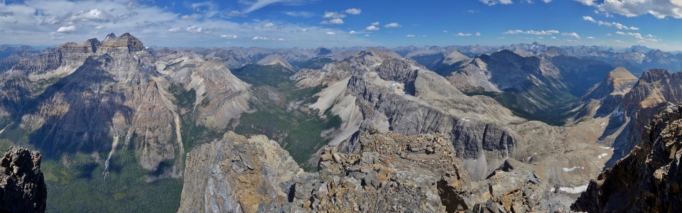
After years of dreaming, hours of bushwacking and hundreds of vertical meters of loose rubble, Ali and I were together at last! The panorama from her summit was amongst the finest I’ve been privilege to and was, without a doubt, worth every bit of suffering that was required to get here! Click to see larger.
.jpg)
I ♥ Mount Alcantara! A very happy Matt stands atop the airy 3,029 m summit of this rarely visited beauty. While we’d encountered no exposure on the entire ascent, the final step to the highest point was surprisingly exposed along the narrow and rotten rock ridge in the foreground of this photo. Fortunately, it took only 1 step to get over the worst bit. Click to see larger. (Photo credit: Matt Clay)
.jpg)
Told you the last step was exposed! A misstep here would lead to a long drop…
.jpg)
A marvelous view as Mounts Aye, Assiniboine and Eon (left) tower over verdant Marvel Pass (right).
.jpg)
A vertical stitch of Aye, Assiniboine and Eon (these peaks were too tall and too close to fit in a single frame)!
.jpg)
Telephoto towards Mount Aye (left), Mount Assiniboine (center) and Mount Eon (right). Assiniboine’s southwest slopes (shown here) are the least technical way up the “Matterhorn of the Rockies” but they’re still intimidating and, by most reports, loose with a high objective hazard.
.jpg)
Marvel Pass’ alpine meadows are bracketed by Mount Gloria (left) and Aurora Mountain and Mount Byng (right beyond some of Alcantara’s cliffy outliers). Beyond the pass, Owl Lake is obvious at the foot of Marvel Mountain and the Kananaskis Range stands tall against the northeastern horizon.
.jpg)
Looking over a sea of peaks to the east. Click to see larger.
.jpg)
Familiar K-Country peaks dot the distant horizon. The Tower, Mount Galatea (distant) left and Mount Birdwood (right) are obvious amongst others beyond yellowish Mount Currie (center right).
.jpg)
11,000ers dot the southeastern horizon.
.jpg)
A second happy Matt sits WELL-back from the edge atop Alcantara.
.jpg)
Mount Sir Douglas rises up beyond Red Man Mountain (center left), Mount Vavasour (center) and White Man Mountain (right).
.jpg)
Glaciated Mount Joffre (center) and the Royal Group (right) pierce the horizon beyond White Man Mountain (left) and Mount Soderholm (right).
.jpg)
Mount Brussilof and Alcantara’s descent gully dominate the panorama to the south. Click to see larger.
.jpg)
A closer look at the impressive rock layers making up Brussilof’s north face as range after range of hazy peaks fade into the background beyond.
.jpg)
Mount Docking rises up beyond the Baymag Mine. The mine exploits one of the purest known deposits of magnesite on Earth.
.jpg)
Even the distant Bugaboo Spires are visible beyond Mounts Harkin (center) and Daer (right).
.jpg)
An ocean of summits to the west including Mount Harkin (left), Mount Daer (center left), Mount Selkirk (center), Caitlin Peak (center), aptly-named Split Peak (center right), Mount Sam (center right), Octopus Mountain (right) and the distant Vermilion Range (distant right).
.jpg)
Not many names in the summit register! Placed in 1999, the register contains the names of only 3 other ascent parties. Katie Gardiner’s first ascent party obviously reached the summit as did Rick Collier’s 1992 party. To the best of my knowledge that would make this the sixth recorded ascent of Mount Alcantara.
.jpg)
Contemplating Assiniboine and Eon whilst enjoying a well-deserved summit sandwich. (Photo credit: Matt Clay)
.jpg)
The scene that accompanied my sandwich. Lunches don’t get any prettier than this!
One final 360° look at the spectacular views from Mount Alcantara’s rarely visited summit. Click and drag to explore. Those with vertigo may wish not to look down! ;-)
.jpg)
Matt starts the loose descent after a lengthy summit stay which consumed an impressive amount of digital memory!
.jpg)
Plunge-stepping down reasonable scree in the descent gully. (Photo credit: Matt Clay)
.jpg)
Enjoying the colorful panorama from the descent gully. The descent was surprisingly pleasant and Matt and I made reasonable time on this section of the mountain. Of course, the “pleasant” and “making good time” aspects of this descent would soon end. Click to see larger.
.jpg)
Once we reached the alpine meadows at the base of the descent gully, we trended towards the skier’s right to regain our ascent line. (Photo credit: Matt Clay)
.jpg)
Another pristine mountain spring discovered during our descent; this one literally appeared out of nowhere from the mountainside amidst a carpet of soft moss.
.jpg)
Matt makes his way back down a small rock band; as feared, the brush seemed thicker on our walk out than it had on the hike in!
.jpg)
Back into the SUCK. Full-on. Everyone has different coping mechanisms in situations like this. I, for instance, curse like a fucking sailor. Matt, on the other hand, forages for berries. C’mon Matt, let’s get down before the bears realize that you’re stealing their food!!!
.jpg)
Hallelujah!!! The cut block marked the beginning of the end with regards to our suffering.
.jpg)
Mount Aye (center) and Mount Eon (right) catch the last of the day’s rays as we negotiate the cut block back to the road below. Funny how we witnessed the day’s first and last light on these same mountains!
.jpg)
The bears in the area may like the raspberries which litter the hillsides but I prefer my raspberries in a bottle!
.jpg)
“Did someone say raspberries?”
As it turned out, my years of fantasizing about “Ali” officially qualify me as a masochist. Nevertheless, my brief time with her didn’t disappoint! People say that “the chase is better than the catch” but they’ve obviously never chased (or caught) Alcantara. I loved being on Alcantara’s sultry summit but, as our time together drew on, I came to realize that what we had was just a summer "fling." Still, I won't soon forget my date with ♥Alcantara♥.
.jpg)
.jpg)
.jpg)
.jpg)
.jpg)
.jpg)