In the Rockies, sometimes the journey is more of an “adventure” than the destination. Thanks to ambiguous directions in Andrew Nugara’s guidebook and my suspect Polish navigation system, the journey to Castle Wilderness’ Whistler Mountain proved to be just that. Nugara states that “the crux of Whistler Mountain is getting to the trailhead” but this needn’t be so! The initial guidebook directions are correct: from Highway 3, follow Highway 507, continuing south into the Castle Wilderness when the road turns into Highway 774 in the tiny community of Beaver Mines. Take the well-signed Beaver Mines Lake turnoff when you reach it (about 15 km south of the community) and follow this well-travelled road another 3.7 km to an unsigned road. From this point on, you may wish to ignore Nugara’s directions (unless you want an “adventure”)!
.jpg)
The first stream crossing provides a great view of Whistler Mountain. The guidebook makes it sound as though this crossing is reached after 4.5 km on the unsigned road. In reality, the stream is 4.3 km from the Highway 774 turnoff ! This means that the stream is reached after travelling only 600 m along the unsigned road. The stream crossing itself was very mellow and, if the flow is low, I wouldn’t hesitate to continue on in a car (be warned that there’s some pretty big potholes on the other side though)!
.jpg)
5.4 km after crossing the tiny stream, this nice grassy pullout on the left provides primo parking at the trailhead. Unfortunately, my Polish navigation system missed it on our first pass! Although the guidebook says to “simply head into the bush” from here, you can find a lovely trail near the southern end of the grassy parking pullout (just behind my SUV in this photo).
.jpg)
The “more serious creek crossing” just beyond the trailhead. Ye be warned: if you get here, you’ve come too far! Unfortunately, we thought that this must have been the first creek crossing based on the guidebook distances. As a result, we “followed” Nugara’s directions, crossed this chasm and then continued an additional 5.4 km down the road. If you think this stream looks bad, you REALLY won’t like where this road leads!
.jpg)
A third creek crossing?! Is this even a road anymore?! By this point, we knew that something was amiss and consulted Bob Spirko’s GPS track (Thank GOD I downloaded it before we left!). The track revealed that we had travelled along this “road” about 5 km too far, unnecessarily crossed 2 creeks, wasted an hour and added years’ worth of wear and tear to my new SUV! Whoops! Sheepishly, we found a place to turn around and repeated the whole damned adventure on our way back to the actual trailhead. At the very least, I confirmed that the new SUV is capable of handling its own on rough roads and not just shuttling my baby girl around town!
.jpg)
Having finally located the correct trailhead, the crazy Polish navi system starts up the steep trail.
.jpg)
Crux scouts the route as the trail switchbacks its way up open grassy hillsides.
.jpg)
After wasting so much time driving to the trailhead, at least we didn’t have to waste any time getting to a good viewpoint! Within 5 minutes of leaving the trailhead, we were out of the trees and immersed in the pleasant panorama of Lys Ridge (left) and Barnaby Ridge (right). Click to see larger.
.jpg)
After the trail meandered through a bit of a brushy section, the terrain opened up again and we were granted a good view of the route ahead. The highpoint on the left is the location of an old lookout while the trail can just be seen as a long(er than it looks), rising diagonal slash (from lower left to upper right) across the red argillite hillside. The summit itself remains hidden from view on the right.
.jpg)
Crux waits for the Crazy poky Pol as the trail crosses red argillite slopes. I was impressed by how well the trail was cut into the very steep hillside here but wouldn’t have wanted to attempt it with much more snow than we had. I can see why Bob Spirko felt the need to use his ice axe when he was here!
.jpg)
The Castle Wilderness is home to beautifully colored rock and some spectacularly twisted trees; I may have to spend some more time here!
.jpg)
Even this impressive root system was, apparently, no match for the harsh conditions here!
.jpg)
After gaining a surprising amount of elevation along the long, rising, trail, we found ourselves atop the ridge crest. The true summit lies ahead (on the far left) while the old lookout is behind (on the far right). Click to see the larger panorama bracketed by these two highpoints.
.jpg)
Raf makes his way up the broad ridge crest towards the summit as the lookout (right) grows more and more distant.
.jpg)
Say “Cheese”! A remote camera has been placed at the summit of Whistler Mountain to capture the expression on people’s faces as they realize that the view up here is somewhat marred by trees!
.jpg)
Crux claims his 64th summit!
.jpg)
The Castle Wilderness panorama unfolds to the south beyond another nearby highpoint on Whistler Mountain (click to see larger). Although this highpoint is shown as the summit on NTS maps, it is slightly lower than the true summit which is correctly shown on Natural Resources Canada maps (according to Sonny Bou anyways). Had this highpoint been free of trees, we might have ventured onwards for an improved view but, bushy as it was, we opted to enjoy the true summit for a few moments before retracing our steps back towards the more open lookout.
.jpg)
A closer look at Mount Gladstone (left) to the south.
.jpg)
Impressive Castle Peak is the highlight of the view from the summit of Whistler Mountain!
.jpg)
Mount Matkin rises up on the Canadian side of the 49th parallel while a host of impressive American peaks dot the southern horizon beyond our “home and native land.” Waterton’s Akamina Ridge can be seen just to the left of Matkin while Montana’s Rainbow Peak, Mount Peabody, Kinnerly Peak and Kintla Peak stretch westward to the right.
.jpg)
Impressive peaks (including Commerce Peak on the center left and Scarpe Mountain on the right) to the west beyond Lys Ridge.
.jpg)
Summit scratches for my “good boy” amongst the twisted summit shrubbery.
.jpg)
After snapping summit photos (and watching Raf climb a tree), we started back along the red rock ridge, hoping for better views from the more open terrain of the old lookout.
.jpg)
Raf enjoys pleasant hiking on open slopes below the lookout. Even the Crazy Polish navi system couldn’t get lost up here! ;-)
.jpg)
After a short hike along the ridge, we reached all-that-remains of the old lookout. Future hikers be warned: this structure is surrounded by old rusty nails which camouflage very well amongst the red rock!
.jpg)
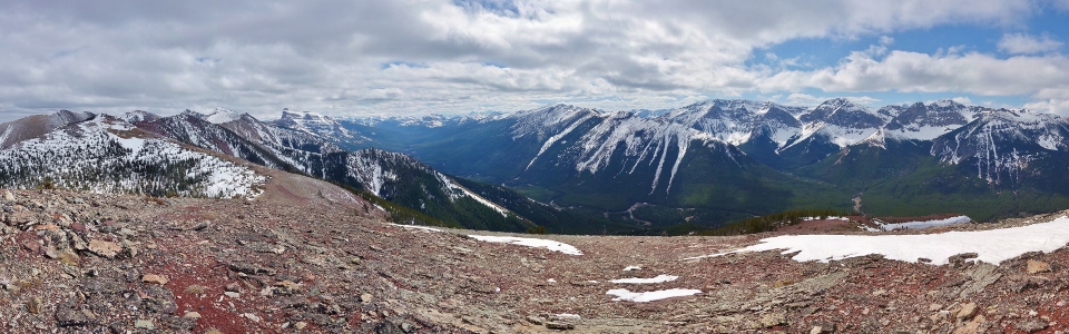
The panorama to the north from the more open lookout is much improved! If you have to choose between the summit and the lookout on Whistler Mountain, I’d definitely pick the lookout. Click to see larger.
.jpg)
The Castle River winds towards the prairies below Syncline Mountain (left) as the Flathead Range runs north towards the Crowsnest Pass.
.jpg)
Crowsnest Mountain (right) presides over the Crowsnest Pass on an overcast afternoon. Mount Ward and Allison Peak can be seen just to the left of the area’s namesake peak.
.jpg)
Turtle Mountain (site of the famous Frank Slide) catches a few rays of sun in the distance. Hillcrest Mountain can be seen to its left while Bluff Mountain can be seen to its right.
.jpg)
Raf, Crux and I pose high above Beaver Mines Lake. Centre Peak is the lone snowy high point on the very eastern edge of the Rockies behind us.
.jpg)
The broad summit plateau of Table Mountain immediately to the east.
.jpg)
The southern panorama towards Castle Peak and the headwaters of the Castle River. Click to see larger.
.jpg)
Castle Peak provides a beautiful backdrop to the red rock ridge which stretches south towards the true summit and beyond towards Mount Gladstone (left).
.jpg)
Barnaby Ridge lies immediately west and has two named high points: Barnaby Peak (center left) and Southfork Mountain (far right). Mount Haig is the prominent peak in the distance beyond the ridge.
.jpg)
On top with my buddy again!
.jpg)
Raf playing with his action figure DOLL.
.jpg)
Crux takes in the view towards Castle Peak one last time before starting our descent.
.jpg)
Rather than retracing our steps back along the ridge, we plunge stepped directly down shale slopes from the lookout and intersected the trail a hundred meters or so below.
.jpg)
Another shortcut on descent; the trail isn’t all that long but Crux was eager to get home to see his little “sister” (besides, open meadows like this are a much better place to pick up ticks)!
.jpg)
Spring is here (and so are the crocuses)!
.jpg)
Last views towards scenic Castle Peak as the mellow trail nears its end. Thanks to the excellent trail up and the broad open ridge above, Whistler Mountain is an easy hike that provides great views of the Castle Wilderness. And, if the peak isn’t adventurous enough for you, you can always have an off-roading adventure in the valley below! ;-)
.jpg)
.jpg)
.jpg)
.jpg)
.jpg)