Saguaro Lake
Elevation: 459 m (1506 feet)
Elevation Gain: 195 m (640 feet) (cummulative)
Round Trip Distance: 8.7 km (5.4 miles)
Saguaro Lake was formed in 1930 when the Stewart Mountain Dam was completed 66 km (41 miles) northeast of Phoenix. The lake is the fourth (and final) reservoir associated with the Salt River Project and provides a popular area for recreation within Tonto National Forest. Saguaro Lake takes its name from the Saguaro Cacti native to Arizona’s Sonoran Desert. These arborescent cacti can grow to be over 21 m (70 feet) tall and their image is indelibly linked with that of the American Southwest.
My Ascents:
March 6 2017.
Trailhead: Butcher Jones Day Use Area
GPS Track: Saguaro Lake
For most of this winter, it's been too cold to hike and explore in the Canadian Rockies. Brianne, Mera and I were, therefore, very much looking forward to our 2017 Arizona pilgrimage. We always say that we're heading south to see Mera's Nannie and Papa but the truth of the matter is, of course, that we've come for the fine (TEMPERATE) hiking that Arizona has to offer!
.jpg)
Someone is ready to hike! She even brought her hiking pole. Shortly after arriving at the "Butcher Jones" trailhead, Mera was off and running.
.jpg)
An aptly placed saguaro on the shore of its namesake lake.
.jpg)
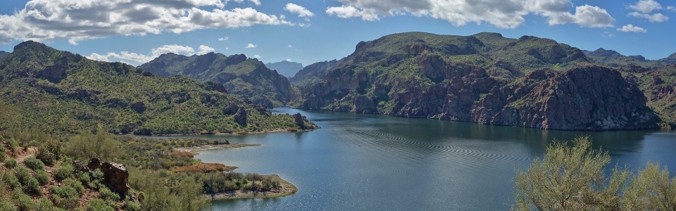
After dawdling around one side of a coot-filled cove (and back along the other), the trail finally starts to pick up steam (and more importantly elevation), leading to the day's high point. From this overlook, a beautiful panorama unfolds as the Salt River empties into Saguaro Lake between Mount Pinter (left) and the Goldfield Mountains (right). Click to see larger.
.jpg)
Capturing a family photo from the trail's scenic high point. If Brianne looks a little larger than usual, it's because she's officially hiking for two!!!
.jpg)
What goes up must of course go down and the trail soon began to lose elevation as it continued east.
.jpg)
Nannie and Brianne enjoy beautiful hiking amidst the scenic desert surroundings. Nannie set an impressive pace for us to follow and we joked that, by being at the front of our pack, she'd make a good "rattlesnake sweep"...
.jpg)
"Did anyone else just hear that bush rattle"?! Clearly Nannie wasn't being a very good sweep for the rest of us! Mouse over to see one of the culprits (there were actually 2 rattlesnakes hidden in the trailside brush).
.jpg)
"OMG - Snakes!!!"
.jpg)
Fortunately, the rattlers weren't all that interested in us and we quickly made our way past them and on towards Burro Cove.
.jpg)
An esthetic (but thorny) outlook atop Burro Cove was our final destination of the day.
.jpg)
Burro Cove panorama. Click to see larger.
.jpg)
Four Peaks (the highest mountain in the Phoenix area) provides a lovely background to Saguaro Lake.
.jpg)
Someone loves hiking with her Nannie and her Papa!
.jpg)
Brianne keeps a close eye on our little explorer. Aside from rattlesnakes, there's a myriad of other ways for a toddler to hurt themselves in the desert!
.jpg)
Feeding time at the zoo...mmm - PB & J wraps!
.jpg)
After enjoying lunch and a brief rest (as though there's any such thing in the presence of a toddler), Mera and Nannie grabbed their hiking poles and we started our trek back towards the car.
.jpg)
The crowd of gawkers made it easier to spot the rattlesnakes on our way back!
.jpg)
The "beach" near the Butcher Jones trailhead comes back into view as our day nears its end. Although the hiking in the American southwest is a little more prickly and venomous than what we're accustomed to, we weren't complaining given that the temperature was 50 degrees warmer than it was back home in the Canadian Rockies! Thanks to Nannie and Papa for a great day out in the desert!
.jpg)
.jpg)
.jpg)