On August 30 2017, Waterton National Park changed forever. A lightning strike on Kenow Mountain (just west of the Park’s boundary) ignited a small wildfire. By September 2, the fire crossed into Waterton National Park. For the next 8 days, fire crews worked tirelessly to contain the blaze near the park’s boundary. On September 11, fuelled by extremely dry conditions, strong winds and hot weather, the Kenow Wildfire broke containment and quickly spread down the Akamina Parkway. That evening, flames were spotted from the Waterton townsite.
By the time that Albertans woke up on September 12, much of Waterton National Park was lost. Thanks to the Herculean efforts of 148 firefighters, the town was saved. The surrounding devastation was, however, widespread. 80% of the park’s hiking trails and roads were destroyed. Parks Canada also confirmed that a number of the park’s natural residents perished in the fire or needed to be euthanized after it. Large mammals (bears, cougars, elk, deer, moose and sheep etc.) are generally able to escape wildfires, however, an unspecified number could not outpace the quick-moving Kenow Fire.
In total, the Kenow Fire burned 38,000 hectares. Nearly a year later, much of the Park remained closed as officials continued to assess and repair damaged infrastructure.
On June 27 2018, however, Parks Canada announced the reopening of several popular trails following extensive work by their Trail Crew. As the site of cherished multigenerational family memories, Waterton holds a special place in our hearts and we immediately decided to mark this occasion with a family hike to (recently-reopened) Bertha Lake.
.jpg)
Driving into Waterton for the first time since the fire proved to be an emotional experience. Although I’d seen photos of the fire’s aftermath, none really prepared me for the extent of the devastation. From near the Park’s entrance, it appeared as though there wasn’t a tree left alive on Mount Crandell (Photo courtesy Gord Hobbs).
.jpg)
An official warning at the Bertha Lake trailhead reminds hikers that fire-related risks remain despite the trail having recently reopened.
.jpg)
Not so long ago, the Bertha Lake trail meandered through dense, lush, old-growth forest. Now blackened tree trunks and a carpet of soot are all that remain in many places. The loss of the beautiful forest is saddening, however, the burnt timber and more-open views towards Vimy Peak are now equally beautiful in a different way.
.jpg)
The townsite is now a lonely oasis of green between the seared slopes of Bertha Peak and Mount Crandell.
.jpg)
Brianne takes in more expansive (but vegetation-less) views above Upper Waterton Lake.
.jpg)
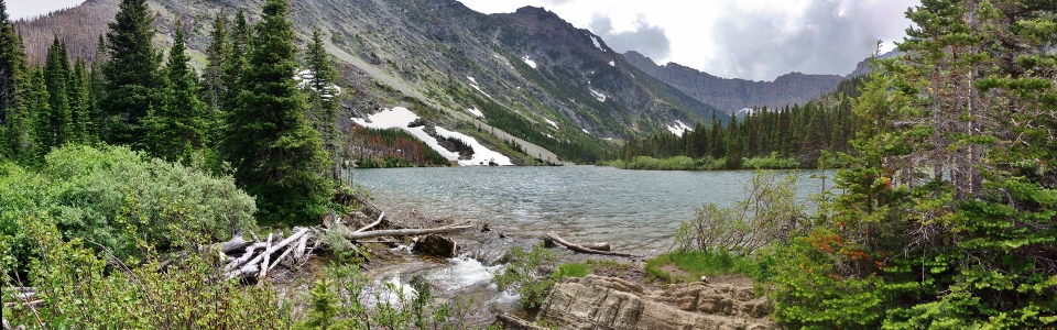
After paralleling the western shore of Upper Waterton Lake for about 1.5 km, a viewpoint is reached where the trail turns westward and follows Bertha Creek up-valley. The outlook features a fine panorama which stretches from Mount Boswell on the far shore (left) to Mount Richards on the near shore (right). The fire’s devastation is apparent all about, however, somewhat remarkably, large swaths of lush vegetation appear to have been randomly spared on Mount Richard’s northeast slopes. Click to see larger.
.jpg)
Bertha Peak comes into view up-valley beyond the once-green forest.
.jpg)
Fireweed is a pioneer species and is often abundant as an early colonizer following wildfire. Over the next several years, it’s likely that Waterton’s burnt amber slopes will turn purple as these beautiful plants take advantage of the suddenly abundant open space and nutrient-rich soil.
.jpg)
Although she doesn’t remember the old forest, Mera was very excited to see the fire’s aftermath (especially when she could see it from ‘up high’ riding on my back) (Photo courtesy Gord Hobbs).
.jpg)
Penny also enjoyed her ‘ride’ up the Bertha Lake trail (almost as much as she enjoyed having both her Grandmas along for the hike) (Photo courtesy Gord Hobbs).
.jpg)
A bridge crosses Bertha Creek at the foot of Lower Bertha Falls (about 3 km beyond the trailhead).
.jpg)
Lower Bertha Falls beautifully framed by greenery. The fast-running water and topography here appear to have conspired to keep last year’s fire at bay (Photo courtesy Gord Hobbs).
.jpg)
Grandpa Gord makes his way through a swath of uncharacteristically green undergrowth above the Lower Falls.
.jpg)
Fire or not, Waterton always seems to be replete with wildflowers (in this case, thimbleberries).
.jpg)
A lone trillium flower sprouts from the ashes.
.jpg)
Continuing upwards as the trail begins to switchback up the valley’s headwall (Photo courtesy Gord Hobbs).
.jpg)
I’m not certain if this sign is old or new but it is apt.
.jpg)
A couple of the ‘Old Giants’ that the previous sign was obviously referring to (although only one of them looks ‘renewed’).
.jpg)
A fiery family photo, taken after another hiker randomly asked if we wanted a group photo. Not finding the setting to be all that scenic, we almost declined but are glad that we didn’t – as it would turn out, this was the only full family photo that we’d have the chance to take!
.jpg)
Looking out over Bertha Peak’s Mordor-like eastern slopes (Photo courtesy Gord Hobbs).
.jpg)
A closer look at Lower, Middle and Upper Waterton Lakes (top, middle and bottom, respectively) (Photo courtesy Gord Hobbs).
.jpg)
With the forest largely destroyed, the hike to Bertha Lake now features more views than ever before. As we marvelled at the new vistas opened up by the blaze, we wondered if we would finally get a good view of Upper Bertha Falls (which had always been mostly hidden by trees). Alas, we did not as the headwall around the Upper Falls seems to be one of only a handful of areas where the forest didn’t burn!
.jpg)
As we crested the headwall, the forest become lush once more and, after a short descent, we reached our destination (about 6 km from the trailhead) (Photo courtesy Gord Hobbs).
.jpg)
Beautiful Bertha Lake.
.jpg)
My beautiful ‘Baby Bear’ and I at the Lake. Although the forecast had called for only a 20% chance of rain, it (of course) grew windy and began to drizzle right as we arrived at the Lake (Photo courtesy Gord Hobbs)!
.jpg)
Mera enjoys a drizzly nap in her hiking carrier. Given the conditions, she slept surprisingly well (at least until a gust of wind blew her over)!
.jpg)
Exploring Bertha Lake’s south shore while looking for the ‘facilities.’ With the forest largely gone, there are now precious few places to pee on this hike!
.jpg)
Bertha Lake panorama featuring Mount Alderson (left) and Bertha Peak (right). While the north shore of the lake appears to have escaped the blaze, the forest along its south shore did not fare as well. Click to see larger.
.jpg)
Scorched earth on the lake’s south shore.
.jpg)
Look who’s awake (after being blown over)!
.jpg)
Mount Richards highlights the view from Bertha Lake’s outlet stream.
.jpg)
Giving Mera a lift across the ‘scary’ bridge over Bertha’s outlet. Seeking a more-sheltered place to enjoy the lake, we made our way a few hundred meters along its north shore (Photo courtesy Gord Hobbs).
.jpg)
Bertha Peak’s burnt north ridge is obvious as the outlet stream cascades over the headwall to the valley below (Photo courtesy Gord Hobbs).
.jpg)
Flower and fire-filled views from the more-sheltered ‘beach’ which we found on the lake’s north shore (near the backcountry campground cooking area).
.jpg)
Enjoying the ‘beach’ with my 2 eldest ‘children.’ (Photo courtesy Gord Hobbs)
.jpg)
My ‘Baby Bear’ Penny and I explored the lake’s north shore while the rest of our group enjoyed a break at the ‘beach.’ Moments after I took this photo, however, our exploration came to an abrupt end when a very large cinnamon black bear suddenly appeared on a ledge about 20 – 30 m from us!
.jpg)
A somewhat shaken selfie as Penny and I beat a hasty retreat! When the bear first appeared, the photographer in me desperately wanted to take a photo but the ‘Papa Bear’ and more reasonable part of my psyche prevailed. Instead of reaching for the camera, I picked up my daughter (duh!) and loudly but calmly alerted the bear to our presence. I proceeded to tell the bear that we were human and backing off. Penny and I then calmly retreated while continuing to speak loudly so that the bear would know where we were. Once we’d put 250 m distance between ourselves and the bear, I allowed myself the luxury of documenting the moment with a shaky selfie.
As I returned to the ‘beach’ I alerted my family and the other hikers there that I’d just seen a large bear 300 m away. While we quickly packed up our belongings, the other hikers seemed nonchalant. I’m not exactly terrified of bears and have probably spent much more time in their presence than I know of but I still reasoned that it would be best to get my family (especially our 2 young children and our dog) out of the area!
.jpg)
At the edge of the lake (about 800 m from where Penny and I spotted the bear), we decided to stop for a quick family photo before starting down. Grandpa Gord snapped this photo of Nannie, Penny, Brianne, Crux, Grandma and I. We were just about to ask another hiker to take a group photo with Grandpa in it when the bear reappeared 30 m from us, crossed the narrow outlet stream bridge and plunged into the brush! Needless to say, the camera was quickly put away as we reached for our bear spray!
The lake was busy so there was comfort that others were nearby, however, we worried that the bear might feel cornered by the crowds. The poor animal probably had this whole valley to itself since waking from its winter slumber. When Parks reopened the trail, however, hordes of hikers were suddenly invading its home. Seeking escape, the bear appeared to venture south towards Mount Richards’ more remote slopes. While this would ultimately grant the bear its desired solitude, it unfortunately, would also force the bear to cross the Bertha Lake trail several more times.
.jpg)
A blurry bear bum photo as the beautiful animal attempts to escape. This photo was taken as we descended and the bear came close to crossing our path once more. In total, I saw the bear 4 times before it presumably escaped to literally greener pastures outside of the burn zone (Photo courtesy Gord Hobbs).
.jpg)
The ‘Bear Patrol’ (an impromptu gathering of several hiking groups) makes their way down on high alert. Note the unsheathed bear spray and many eyes keeping a keen lookout… (Photo courtesy Gord Hobbs)
.jpg)
As time passed and it seemed more likely that the bear had wandered elsewhere, we let Mera back out of the hiking carrier and a sense of normalcy returned to our descent.
.jpg)
The sight of bear grass proved less alarming than the earlier sight of the flower’s namesake apex predator.
.jpg)
Mera, Crux and I enjoy the view from the fire-ravaged lookout where the trail turns abruptly back towards the Waterton townsite (Photo courtesy Gord Hobbs). By this point, Brianne and Penny were well-ahead of us and ‘highly motivated’ to get down. My poor wife had needed to use the ‘facilities’ at the lake but wasn’t keen to wander into the brush after the day’s numerous bear encounters! Making matters worse, by the time that we’d descended far enough to feel safe once more, there was no more forest-cover left to serve as a ‘ladies’ room!’ Future hikers take note: if you need to use the ‘facilities’ on this hike, there are a lot fewer discrete places to do so!
.jpg)
A colorful rainbow enhances our final views across Upper Waterton Lake towards Vimy Peak as our hike nears its conclusion.
.jpg)
Final (flower-filled) views back towards Waterton taken during our drive home. Bertha Lake rests unseen in the valley between Mount Richards (center) and fire-ravaged Bertha Peak (right). The Kenow Wildfire forever changed the landscape here but Waterton’s beauty is undiminished. Like a phoenix rising from the ashes, Waterton (and its resident bears!) are beautifully back! (Photo courtesy Gord Hobbs)
.jpg)
.jpg)
.jpg)