As the calendar turned from May to June, warm summer weather finally arrived in Southern Alberta (albeit with accompanying wildfire smoke). Brianne and I had discussed a family hike earlier in the week but, after a challenging night prior which featured tummy troubles and sleepless tots, a lazy day around the house didn’t sound terrible. As we finally drifted off on Friday night, we were fairly non-committal about our Saturday plans. Upon waking to sunny, blue skies, however, we remembered that we don’t do lazy days. We hike. No one remembers the Saturday that they spent at home but bagging peaks as a family creates a lifetime full of memories (cherished and otherwise)!
With an eye towards family bonding in the fresh mountain air (and perhaps adding a new summit to Dad’s tally), we set out for Plateau Mountain. As described on the Alberta Parks website, the Plateau Mountain Trail (read: road) sounded like a perfect peak to tackle with our tots. Plateau Mountain is deceptively big (which made it appealing to me) but you’re supposed to be able to drive a good way up its west slopes using a well-maintained O&G road. The only problem is: the road isn’t always open! The road features 2 gates (1 at the bottom and 1 at the trailhead). The upper trailhead gate is perpetually locked and keeps the summit from being overrun with OHVs. The gate at the bottom is supposed to be open to allow access to the trailhead but a quick scan of online trip reports revealed that it’s often locked. When locked, Plateau mountain goes from a 12 km return 320 vertical m day to a 24 km return 620 vertical m day. Obviously, the former sounded more reasonable with tots in tow!
Hoping like heck that the bottom gate was open, we left Calgary and drove 2 hours south. I’d never driven Highway 532 and was surprised to discover how steep and scenic it was. Better still, as we left the main road, we were relieved to discover that we hadn’t subjected our daughters to an unnecessary 2-hour drive; the lower gate was open!
.jpg)
Having been able to drive 5 km and 300 vertical meters up the road, Brianne and Penny were all-smiles at the Plateau Mountain trailhead (note the upper locked gate ahead of our car)!
.jpg)
Mera, on the other hand, was too busy playing with a nearby meltwater stream to give a damn about the day’s distance or elevation gain.
.jpg)
And we’re off! Beyond the trailhead gate, the road continues gently upward allowing for easy hiking all the way up (and over) Plateau Mountain.
.jpg)
Occasional clearings grant views to the west. While the trailhead is located below tree line, you only need to hike 1.5 km along the road before reaching more open alpine views.
.jpg)
Pink pussy willows herald the arrival of spring in the Rockies!
.jpg)
Mera seeks out some added challenge during our ascent. I’d specifically picked Plateau Mountain since its road promised to be easy enough for a 3-year-old to hike up. Despite the presence of a well-graded road, however, Mera insisted upon rock-hopping whenever possible.
.jpg)
Roadside snow also provided a common distraction (for both Mera and Crux). This girl must be related to Karen Christison or something…
.jpg)
Mera and her Mom check out the improving views as we approach tree line.
.jpg)
Nearby Pasque Mountain (center) looks like another tempting early-season ascent in the area.
.jpg)
Who let the “Bear” out?! After escaping from her hiking carrier during a snack-break, Penny enjoyed some high quality toddling in the warm June sun.
.jpg)
My girls near the road’s first switchback/hairpin turn about 1.5 km from the trailhead. Ahead, the road turns abruptly north and Plateau Mountain is finally revealed.
.jpg)
A summit so broad, it fills an entire panorama! Upon first sight, the scale of Plateau Mountain’s expansive summit is impressive to say the least. From here, we followed the road north for another 1.5 km before it turned west and climbed the summit plateau using a pair of obvious switchbacks. Click to see larger.
.jpg)
A closer look at the obvious switchbacks on Plateau’s west slopes which would only be necessary if you were actually driving; the rest of the slope is eminently hike-able.
.jpg)
Brianne enjoys the peace of the alpine air and a rare moment without having either of our kids seeking attention…wait a minute…where’s Mera?!
.jpg)
… Ah, jumping off a nearby rock, of course.
.jpg)
Brianne attempts to keep Mera engaged by pretending that they're airplanes. As you can see, one of them is pretending harder than the other! I think we all had a lot of fun on this hike. More insignificant details were explored than ever before. More songs were sung. When you’re trying to keep a 3-year-old engaged, it really helps to be a kid at heart.
.jpg)
While Mera insisted upon climbing up and jumping over every obstacle that she could find, Penny was more than happy to hitch a ride on Dad. Why burden yourself with physical exertion when someone else will do it for you?
.jpg)
Mera was quite keen to visit this rock (and we didn’t complain since it allowed us to cut a hundred meters or so off of an unnecessarily long switchback).
.jpg)
Mera’s not the only one who can jump off rocks! From her perch, Penny looks pleased that “Daddy” stuck the landing while Crux looks on confused.
.jpg)
♫ On the road again (literally) ♫
.jpg)
Bovine remains near a drainage on Plateau’s west slopes. Surprisingly, Mera was more interested in these bones than Crux was!
.jpg)
Pastoral views down the drainage towards Pasque Mountain.
.jpg)
As we continued upwards, we were granted some nice views of the hazy High Rock Range to the west. I figured that this would be a good place to get a nice photo of Mera and Brianne (and Crux) but Mera had other plans and refused to smile. Instead she turned around, drummed her a$$ and chanted “Look at my butt-butt!” over and over again. Just another one of those "cherished" family hiking memories that I was hoping to make…sigh.
.jpg)
Opting to save some distance, Brianne and Mera enjoy a scenic shortcut on Plateau Mountain’s west slopes.
.jpg)
The jagged peaks of the High Rock Range provide some “oomph” to the, otherwise, pastoral panorama. Click to see larger.
.jpg)
Penny enjoys another respite from her hiking carrier while the rest of us enjoy the improving views to the west.
.jpg)
Raspberry Ridge is obvious to the northwest and looks to be another of the area’s many tempting tot hikes.
.jpg)
Second lunch of the day (and we’re still only 3.5 km from the car!).
.jpg)
After refueling, Brianne and Mera enjoy some pleasant cloud scenery on route to Plateau Mountain’s expansive top.
.jpg)
Atop the plateau and running out of gas; despite our many lunch breaks, Mera tired out around km 5 and we loaded her into the hiking backpack shortly thereafter. By this point, we’d covered all of the required elevation gain (reaching the final contour on Plateau’s topo map) but still had about 1 km to cover to reach the actual summit.
.jpg)
Mera enjoys a well-earned plateau-top nap while “Dad” takes in the unusual scenery. The 14 square km top of Plateau Mountain feels like the prairies except that it’s over a thousand vertical meters above them!
.jpg)
Meltwater pools add some variety to the pleateau’s panorama. Click to see larger.
.jpg)
Brianne and Penny amble southward as the road nears an inactive gas facility.
.jpg)
According to the "Friends of Kananaskis" newsletter, the gas wells atop Plateau Mountain were capped in 2010 when Devon closed the plant in Coleman that processed the hydrocarbons that they produced. Normally, I’m anti-development but we certainly enjoyed the road that was built to access these wells and Husky Energy was, apparently, instrumental in having Plateau established as an ecological reserve within Kananaskis. In this instance, I therefore tip my hat to Husky for their fine example of good corporate citizenship.
.jpg)
Brianne navigates the surreally flat plateau in search of the actual high point (a rounded bump faintly visible on the horizon to her left). Click to see larger.
.jpg)
Meadows and lakes in the sky.
.jpg)
Straight lines mark the now-inactive pipeline that resides below the surface near Plateau’s, otherwise, featureless summit.
.jpg)
With no obvious obstacles between us and the faintly-visible summit cairn, we decided to leave the road behind in an attempt to shortcut to the summit (which is about 1 km southeast of the gas well pictured earlier). When we did so, however, we failed to account for the fact that the summit plateau is, essentially, tundra. As you can see, hiking across the tundra in June will net you wet boots!
.jpg)
A summit like no other in the Canadian Rockies! Apart from this cairn, there’s little to distinguish Plateau Mountain’s highest point!
.jpg)
Penny, of course, had to climb the cairn to be 100% certain that she’d reached the summit proper.
.jpg)
Two of my three girls atop Plateau Mountain (Mera was still in the midst of an uncharacteristic nap and we weren’t about to wake her)!
.jpg)
Mount Burke rises up beyond a cornice to the north. The cornice was one of very few features that served to remind us that we were not in the midst of a vast plain but actually atop a mountain.
.jpg)
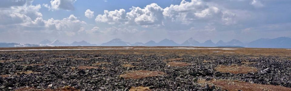
Plateau’s “patterned ground” is another unusual periglacial feature that is preponderant near the summit. These sorted rock polygons are the result of repeated freeze-thaw cycles which force colder, less-dense water to the surface pushing large rocks upwards. Once at the surface, areas with lots of large rocks are less water-rich than areas made of soil/sediment. The more water-rich sediments expand and contract to a greater degree than the large rock piles during freeze-thaw cycles and this ultimately leads to lateral forces that move the larger rocks into unnatural-looking patterns. Above the perfectly flat patterned ground, the panorama of High Rock Range peaks looks positively out of place! From left to right: Mount Gass, Mount O’Rourke, Mount Pierce, Mount Farquhar, Mount Hornickel, Mount Holcroft, Mount Scrimger, Gill Peak and Mount Etherington. Click to see larger.
.jpg)
Smaller front range peaks highlight the panorama to the east including (from left to right): Sentinel Peak, Iron Creek Mountain, Hailstone Butte, Saddle Mountain, Mount Hornecker, Mount Livingstone and Coffin Mountain. Click to see larger.
.jpg)
A closer look at the fire lookout atop nearby Hailstone Butte...it certainly looks like there are all sorts of family-friendly peaks to explore in this area!
.jpg)
Summit selfie with one napping 3-year-old, one overtired 1-year-old, a happy mountain dog and my lovely wife. I’d have loved to explore the summit plateau (particularly its vertiginous eastern end) a bit more but a cry or two from our youngest convinced me that we’d best get moving again and, so, we began our “descent.”
.jpg)
Holy Cross Mountain rises above Brianne as she makes her way “down.” Having had enough of the muskeg on the hike up, we wisely opted to plot a course that involved staying on the road for as long as possible on descent. By this point, Penny had fallen asleep while Mera had awoken. Mera was, however, happy to remain in the hiking backpack and we were happy to keep her there so that we could make it back to the car in a (somewhat) timely manner!
.jpg)
Scenic twists in the Plateau Mountain road as the High Rock Range begins to fade from view.
.jpg)
Weary and each laden with an approximately 30 lb child, Brianne and I opted to shortcut several switchbacks on descent. Mercifully, these shortcuts proved less boggy than the one which we took on the tundra above!
.jpg)
♫ On the road again ♫ (though mercifully near its end this time!)
.jpg)
Didn’t notice those prints on the way up (and I don't think they're from our "Penny Bear")! Yo Bear!!! Fortunately, we didn’t run into their maker and were soon happily seated in our Highlander.
As we cruised down the bottom 5 km of the road in air-conditioned comfort, the girls snacked on Timbits® while Brianne and I enjoyed some satellite radio and basked in the afterglow of an awesome family hike filled with (mostly cherished) memories. Days like this are the reason we hike!
.jpg)
.jpg)
.jpg)
.jpg)
.jpg)
.jpg)