Elevation: 2587 m
Elevation Gain: 1100 m
Queen Victoria was born in 1819 and ruled the British Empire from 1837 until her death in 1901 (the longest reign of any monarch until Elizabeth II). The Victorian Era coincided with the greatest glory of the British Empire. It was during this time that Victoria granted Royal Ascent to the British North America Act, making her the “Mother” of Canadian Confederation. As a result, her name is the most honored in Canada and appears on our maps over 300 times. In the Rockies, many notable features bear her name including world-famous Mount Victoria above Lake Louise and less-famous Victoria Peak near Pincher Creek. The latter may not be featured on as many postcards as the former but its pyramidal east face, which rises over a kilometer above the Alberta prairies, nevertheless, endows it with a suitably regal air.
My Ascents:
May 10 2019
Trailhead: Victoria Ridge Trailhead GPS Track: Victoria Peak
As I pored over our increasingly-busy family calendar for the month of May, I noted commitments or activities on, essentially, every single day. Many of the activities were things that I love doing (Stamps FanFest, Mera’s soccer games, kegger dino parties for toddlers etc.) while the commitments (work etc.) were just that. Despite the fact that the month promised to be filled with fun, my angst rose as I noted that little room was left for mountain adventures. We’re a busy family and I’m pretty Type A so a schedule is a must. Still, the adventure that I crave can’t be scheduled and, despite looking forward to my family plans for the month, the lack of free days started to feel like a restrictive shirt collar. Fortunately, as I started to muse about needing “air”, my in-laws rode to the rescue with an offer to babysit. I hate feeling like I’m picking a mountain over time with my girls but I knew that the adventure I craved was unlikely to be sated at home. Sometimes I just need a rejuvenating day in the mountains to remind me of how rewarding being a dad and a husband is all of the other days. I also knew that my girls wouldn’t even notice my absence once their beloved “Nannie” and “Papa” arrived! With my mind at ease and with an eye towards adventure, I, therefore, set out; and what an adventure, the day ended up being!
After a quick morning cuddle with my youngest (who decided to rise and shine earlier than anticipated), I gratefully handed the littles over to their grandparents and embarked south towards Pincher Creek in the hopes of hiking up Victoria Peak. Victoria is typically ascended via the moderate Nugara scramble route on its southeast slopes. After Matt Clay brought an easier (but longer) hiking route to my attention a few years back, however, I decided that it might be a great shoulder season objective; certainly big enough to grant a sense of accomplishment during a time of year when that’s hard to find in the mountains! Despite being the tallest and shapeliest peak in the area, the slopes that Matt Clay ascended looked to be benign enough to be feasible despite this year’s never-ending winter and I hoped that their southwest orientation might even result in them being bare (not “B-E-A-R ”, mind you…)!
As I drove south, my excitement at the prospect of getting out was quickly tempered by overcast skies and light rain. Days earlier, 9 of the 10 weather models that I consult showed sunny skies while 1 showed rain and low cloud; I now knew which model was correct. Arriving at the gated “trailhead” (read: clearing by said gate), Victoria’s unexpectedly snowy and foreboding appearance gave me further pause. Doubting myself, I even got back into my car and started driving towards a less-ambitious “plan B” peak before erratically pulling a U-turn on the dirt road and returning to Victoria. Filled with doubt, I decided that it was better to try and fail than to turn around before I began.
After climbing the gate (note to Shell Canada: please unlock the smaller non-motorized access gate!), I set off down the well-maintained road passing all variety of pipeline infrastructure. Nearby flares and signs warning of poisonous gas made for unusual hiking sights.
Crux poses proudly after overcoming one of several significant obstacles on the O&G approach road. Indeed, this cattle grate (and another similar one) almost put an end to our day before it started. The grates might not pose much challenge for hiking boots but their spacing makes canine-crossings a feat – all part of the day's adventure...
Despite the somewhat unsightly O&G infrastructure, the well-maintained road did allow for quick and easy travel. Note to self: said travel would be much quicker and easier with a bike in future!
Views of vapor and Victoria.
Prairie crocus: a sign that spring may soon arrive in the valley-bottom. Sadly, it didn't appear to be here yet!
After a relatively speedy 3.8 km, we reached the (literal) end of the road and continued along the, much-less travelled, Victoria Ridge trail. While the open road was snow-free, many sections of the trail, shaded by trees, were sadly snow-bound. As a light rain fell, I began sinking with every step and hoped that this trail wasn’t a harbinger of things to come.
My – what big paws you have! For better or worse, the snowbound trail let me know that I was not alone in this valley. With the temperature already above 10 C, it was obvious that someone else had been here very recently. Moments later, I nearly had a god-damned heart attack when a grouse loudly flew away from the brush near my feet! I now know what kind of scream I’ll unleash if I ever think that a bear is charging me from close-range. Spoiler alert: it isn’t manly.
Despite ursine uneasiness and the god-damned heart-attack-bird, the Pincher Creek Valley was scenic and hiking along the Victoria Ridge trail was pleasant (when said trail wasn’t buried under knee-deep snow).
The upper reaches of Pincher Creek are replete with minor cascades. It was a pity that I was in “making time” mode for this section of the hike. I’m sure that one could find all variety of neat spots for photography by exploring the creek’s confines more closely.
After the trail spent a good deal of time in the open, I spotted an appealing slope that looked like it would take me to Matt Clay’s ascent ridge. Matt stayed on the trail for longer than I did and reported that his route involved a “short stint of very intense bushwhacking.” Eager to avoid this, Crux and I made our way up this steep (but open) slope to gain his ascent ridge. Mouse over to see our line.
Pleasant views of Pincher Ridge from our open ascent slope. At the bottom, you can see the drainage which allowed Crux and I to completely avoid bushwhacking as we left the trail.
Crux pauses for a breather (in fact, he paused for so many breathers that I briefly became quite frustrated with him). Our slope may have been open but it steepened considerably near the top! Unfortunately, this photo doesn’t really do the slope angle justice but it was definitely TFS!
At the top of the open slope, our route merged with Matt Clay’s and we were greeted with a nice view towards colorful Victoria Ridge (framed by one of the Castle Wilderness’ many photogenic dead trees).
“Leisurely” travel up dinner plate scree eventually led to a broad plateau 400 meters below the summit. Our open slope by-pass was shorter than Matt Clay’s route and avoided “intense” bushwhacking but it had been a gut-buster so Crux and I were both keen on a lunch break at the plateau.
Upon reaching the plateau, we enjoyed a hearty repast while sizing up the remainder of the ascent. The plateau itself and open slopes above were snowier than we’d hoped for but I reasoned that we could stick to thinner areas to avoid any possible avalanche hazard on steeper, deeper slopes. At the very least, we didn’t need to worry about solar-triggering today! Mouse over to see the line that we took.
When I asked Matt Clay about Victoria, he’d warned me that the forested sub-summit plateau would almost certainly hold snow late into the season. After lunch, Crux and I discovered that he was quite correct! In many places, the snow was deeper than my poles (130 cm) and the snowshoes that, until now, had only weighed me down were suddenly much-appreciated!
After weaving through the forested plateau, we reached the base of the steep, open slopes. I don’t think this slope was deep enough to slide on this day but it was certainly steep enough! Crux and I, therefore, quickly crossed to the climber’s right, aiming for the gentler, (slightly) drier rib.
As we started to ascend, I noticed that a boulder was moving. Wait a minute…boulders don’t move…
When I set out to climb Victoria Peak, I’d been hoping for bare summit slopes but, instead, found B-E-A-R summit slopes. I have no idea what this grizzly was doing way up in the winter wasteland above but, fortunately, he was about 150 meters above us and appeared keen to plot a course away from where we were heading. Just when you think it’s safe to put the bear spray away…
Crux enjoys a quick break while I attempt to capture the rapidly vanishing panorama south towards Pincher and Victoria Ridges. Moments after this photo was taken, the view completely disappeared and I resigned myself to a summit whiteout as the snow began to fall more heavily. At least I’d seen a hint of a view before the squall moved in! Click to see larger.
Upon reaching the summit, we were greeted by eerie views that hinted at the airiness surrounding us.
Despite the falling snow and thick mist, the air was unusually warm and dead-calm. As I explored the cairn (which was really the only thing I could see!), I discovered a delightful summit register. Enchanted by its bright butterflies and, with no pressing need to escape the usual summit cold, I wrote my piece and settled in for a read.
After amusing myself with the register for a while, I looked up and unexpectedly saw something!
Grabbing my camera, I was shocked when the skies cleared in front of my eyes! Mouse over to see two photos that I took only seconds apart.
An unexpected gift! Blue skies and a peak-filled panorama to the north! Click to see larger.
Looking beyond suddenly-sun-kissed Mount Gladstone (center left) and Table Mountain (center right) towards the more distant, snowier Flathead Range.
A closer look at colorful Table Mountain. Beyond, Mounts Darrah (center left) and Ptolemy (center right) are among the Flathead’s more impressive features.
Distant Crowsnest Mountain (center right) stands out among the many peaks to the north.
Brooding views towards nearby Prairie Bluff complimented by Victoria’s ever-present summit plume.
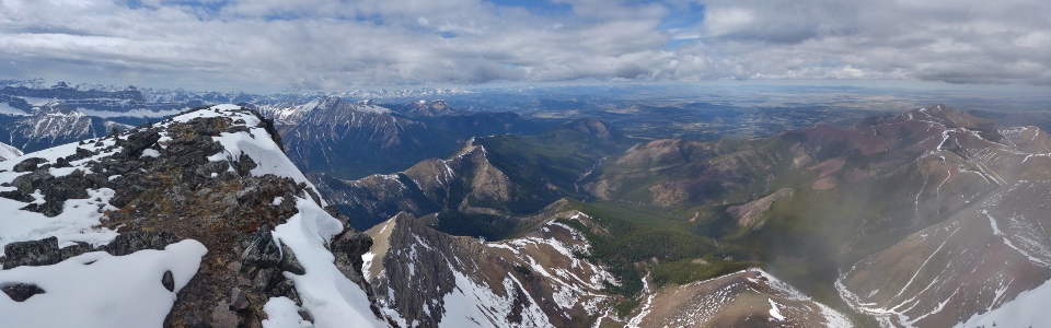
The weather to the west makes for an unsettled panorama (but at least it’s a panorama)! Click to see larger.
Crux is “overjoyed” with the improving summit views.
Undoubtedly, the Windsor/Castle Mountain massif to the west is the highlight of the summit view from Victoria.
A never-ending series of red rock ridges snake southward towards Waterton National Park. Click to see larger.
After enjoying unexpectedly improving weather atop, Crux and I began our descent (keenly aware that we were now walking towards the grizzly that we’d spotted an hour or so earlier!). “Yo Bear!”
Last views towards aptly-named Castle Mountain as we prepare to leave the ridge behind. In the distance, snowy Mount Haig is the obvious pyramid visible over Castle’s shoulder.
As we descended to the snowy plateau below, the pleasant panorama to the south provided a frequent excuse for breaks to enjoy the view of the area’s many intertwining ridges (including from left to right: Pincher Ridge, Drywood Mountain, distant Mount Cleveland, Loaf Mountain and Victoria Ridge). Click to see larger.
After another quick break on the sub-summit plateau, Crux and I enjoyed a wonderful scree descent. Upon reaching the slope’s photogenic dead tree, we were forced to make a decision: descend the very steep slope which we ascended (out of sight to the left) or continue straight down wonderful scree the way that Matt Clay had ascended (shown here). After peering over the veritable precipice that we came up, we decided to stick to the more gently-angled scree (and hoped that the bushwhack below wasn’t as fierce as Matt made it sound).
Following our descent of the long, lovely scree slope, we reached a snowy drainage and started our bushwhack back towards the Victoria Ridge trail in the valley below. Initially, snow in the drainage made for decent travel but, soon, we were sinking up to our hips and were forced into thicker brush. The bushwhack back to the trail was not pleasant but it didn’t strip the skin from my face, arms and legs so it couldn’t have been that bad.
After a modest thrash, we reached the trail and were able to, once again, enjoy this charming little valley as we hiked out. Usually, the hike out from a peak is tedious but, on this day, I actually enjoyed it! The upper reaches of Pincher Creek are lovely and the valley has an alpine character that makes it more beautiful than most. The constant soothing babble of Pincher Creek filled the air while the sun warmed us with its embrace. We didn’t even run into any more god-damned heart-attack-birds!
On the road again…(literally). While the O&G road out isn’t all that exciting, it does allow for relatively quick travel and, soon, we were back at the trailhead, bringing our adventure to an end. Rejuvenated, I couldn’t wait to get home for some quality time with my girls.
.jpg)
.jpg)
.jpg)
.jpg)
.jpg)
.jpg)
.jpg)
.jpg)
.jpg)
.jpg)
.jpg)
.jpg)
.jpg)
.jpg)
.jpg)
.jpg)
.jpg)
.jpg)
.jpg)
.jpg)
.jpg)
.jpg)
.jpg)
.jpg)
.jpg)
.jpg)
.jpg)
.jpg)
.jpg)
.jpg)
.jpg)
.jpg)
.jpg)
.jpg)
.jpg)
.jpg)
.jpg)
.jpg)
.jpg)
.jpg)
.jpg)
.jpg)
.jpg)
.jpg)