After our failed early season attempt on Sofa Mountain, Crux and I decided to look for a more suitable furniture-themed peak to climb (so odd to climb furniture-themed mountains when I find myself constantly reminding my toddler that “the furniture is not for climbing…”)! To this end, Table Mountain made for an enticing objective. With its location among the eastern Front Range peaks, Table Mountain is often snow-free much earlier than the larger peaks to its west. Thanks to a post on the “Scrambling in the Canadian Rockies” Facebook page, we knew that the peak was relatively dry and, therefore, set out to climb some “furniture” in newly-created Castle Provincial Park.
.jpg)
Following the 2.5 hour drive south, we easily found the Beaver Mines Lake campground and the "Table Mountain" trailhead therein. Although it was easy to find the trail, we nevertheless had a small adventure which involved one of our party rolling around in a pile of noxious decomposing fish/bait left behind by nearby anglers. Consequently, someone got to spend the day smelling like rotting fish. Surprisingly, that someone was not Crux! All I can say is: be careful where you set your gear or yourself down near Beaver Mines Lake!
.jpg)
With brilliant blue skies forecast midweek (and the usual rain expected on the weekend), Crux and I had little trouble convincing Aurore to skip work and join us on this malodorous misadventure. After not seeing her all winter, her company was most welcome. Given that I reeked of fish, I’m not sure that she felt the same way. Nevertheless, it was great to catch up (even if we had to do it while breathing exclusively through our mouths).
.jpg)
After following the trail through aspen forest for about 20 minutes, we reached a clearing where the path split. The smaller path to the climber’s left leads to the scrambler’s route in the gully high above. The more well-travelled path to the climber’s right leads to the hiker’s route up the next significant gully to the east (out of sight in this photo). After a long, snowy winter, none of us were in hiking shape (note the exhausted tongue protruding from Aurore’s mouth!) so we opted to follow the gentler hiking trail!
.jpg)
An unexpected wildlife encounter. Apparently garter snakes pay little heed to “Yo Bear!” shouts from passing hikers!
.jpg)
Aurore follows the hiker’s trail across open (snake-filled!) hillside towards the left-most gully ahead.
.jpg)
Water cascades forth from remnant snow in the hiker’s ascent gully. The trail became difficult to follow in the gully thanks to lingering snow. I expect that the trail remains "rugged" here even when the snow is gone thanks to a multitude of washouts.
.jpg)
Initially, the gully is surrounded by steep rock walls coated in spectacularly vibrant lichens.
.jpg)
Aurore follows my fish-scented steps up firm snow in the gully. Despite painted rebar markers, it was occasionally hard to follow the trail. Indeed, on descent we saw a party mindlessly clamboring up the steep rock slope behind Aurore. If in doubt, my advice would be to follow the gully; the point at which the trail finally leaves the gully behind is well-marked! If you leave the gully too early, you'll make matters much harder than they need be!
.jpg)
Crux looks quite pleased to be back in the snow!
.jpg)
Although the firm snow made for a pleasant ascent, it was still a good idea to mind your step as some areas were thinner that others…
.jpg)
When the trail does finally leave the gully, it quickly led up steep slopes to a small bench half-way up the hillside. From here, there are 2 possible trails (mouse over to see). The left-most trail ascends diagonally through trees; it’s a little difficult to spot at first and you may have to side-hill across some easy terrain to get to it but I highly recommend taking it on ascent. The trail on the right is very steep and very loose and much better-suited for descent. If you find yourself going up the descent trail, you’re likely to utter a few “choice words” while you try to catch your breath. The rock is loose and the buttress at the top is a lot further away than it looks from below!
.jpg)
Aurore and Crux make their way up the very pleasant ascent trail.
.jpg)
The wind-twisted remains of an oft-photographed pine. When I stopped to take this photo, Aurore criticized me for taking a photo of the exact same tree that everyone else does. She then proceeded to pull out her phone to do the same!
.jpg)
The left-hand ascent trail eventually crests the ridge at a point above the scrambler’s ascent gully. This overlook also provides the day’s first good view towards the snowier peaks of the more westerly Flathead Range. Click to see larger.
.jpg)
From the overlook, the trail continues north and east past photogenic pines towards the mountain’s table-like upper plateau.
.jpg)
As we reached the upper plateau, we were shocked to discover how suddenly the peak’s north face drops towards Beaver Mines Lake below. Click to see larger.
.jpg)
Although the summit was due-east along the upper plateau, this oft-photographed dramatic outlier to the west was begging for a side trip. Crux and I, therefore, jogged west while Aurore stayed behind with my camera to capture this perfectly Instagrammable pic. Click to see larger and be sure to look for the tiny Matt and the tinier Crux!
.jpg)
Just a boy and his dog out for a casual morning stroll.
.jpg)
The mountain’s table-like upper features stretch out towards its summit (left) some 2 km to the east and less than 100 m higher. Click to see larger.
.jpg)
Aurore enjoys a wonderful walk along the meandering plateau. The summit is visible immediately east here but we’ll need to continue south along the broad ridge before making our way back north up its gentle right-hand ridge. The route to the summit is by no means direct but with a ridge walk this nice, we were in no particular hurry to get there! As an added bonus, the pleasant ridgetop breeze helped to disperse the awful aminic aroma that we'd been enduring throughout the ascent!
.jpg)
Table Mountain’s mellow red rocks stretch southward towards snowier mountains including (from left to right): Mount Gladstone, Windsor Mountain, Castle Mountain, “Larry Mountain” and “Frankie Peak”. Click to see larger.
.jpg)
Playing photographer: red rocks and red gaiters (which are apparently on backwards – whoops!).
.jpg)
The reason for said-gaiters! One last significant snow patch amid a needleless larch forest at the summit’s base. Someday, I’ll need to come back here in the fall to see the golden fall colors highlighted by the prolific red rock.
.jpg)
Beyond the snow, the summit was but a short plod away!
.jpg)
After a pleasant stroll, we finally reached the summit and were treated to pastoral prairie views to the east.
.jpg)
An Alberta Government Survey marker denotes the true summit.
.jpg)
Rolling foothills give way to wind turbine-laden prairies further east.
.jpg)
The drop from Table Mountain’s more easterly true summit is as impressive as that from “Instagram Point” on the peak’s west end.
.jpg)
Once on the summit, Crux quickly located a snow patch and plopped himself down for a well-deserved rest. Note the fascinating pattern in the rock directly behind his head.
.jpg)
A closer look at the previous photo’s rock reveals that Table Mountain’s summit was once a beach!
.jpg)
Colorful peaks give way to prairie in this southeasterly panorama. Click to see larger.
.jpg)
Prairie Bluff is the most easterly peak to the south.
.jpg)
Beautiful views of Castle Provincial Park peaks to the south. From left to right: Drywood Mountain (distant), Victoria Peak, Loaf Mountain (distant), Mount Gladstone, Castle Mountain, “Larry Mountain”, “Frankie Peak”, Commerce Mountain (distant), Whistler Mountain, Scarpe Mountain (distant) and Lys Ridge. Click to see larger.
.jpg)
Castle Mountain’s dramatic summit block highlights the view to the south. Further south still, the twin summits of Kinnerly Peak and Kintla Peak are visible 45 km away in Montana’s Glacier National Park.
.jpg)
“Larry Mountain” and “Frankie Peak”: unofficially named for Andrew Nugara’s stepfather and “mum”. I guess when you’ve climbed as many Castle peaks as Andrew has, you get to start naming them…it helps to write the area guidebook as well no doubt!
.jpg)
With a little bushwhacking (and on this day a great deal of post-holing), Nugara indicates that it is possible to continue hiking south to Whistler Mountain if one is so inclined. We were not! :-P
.jpg)
A closer telephoto look at Scarpe Mountain (left) and Lys Ridge (right).
.jpg)
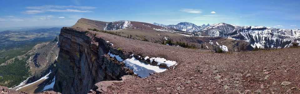
While the southern summit panorama was lovely, the panorama to the west was its equal featuring Table Mountain’s dramatic east summit, Beaver Mines Lake and the snowy Flathead Range. Click to see larger.
.jpg)
A scenic but smelly summit photo. Who rolled around in the rotting fish by the lake again? Bad Matt!
.jpg)
Looking west beyond Table’s plateau towards Barnaby Ridge (center) and more distant Mount Haig (right).
.jpg)
Syncline Mountain’s twin summits rise up beyond “Instagram Point”. If you look closely, you can actually spot a couple hikers taking selfies.
.jpg)
Aurore rejoices as she finally escapes the fish smell by wandering out to a precarious point upwind of me. Click to see larger.
.jpg)
Mount Darrah (right) is one of the more aesthetic peaks visible to the west.
.jpg)
Crowsnest Mountain dominates the view to the northwest.
.jpg)
Centre Peak (the highest point of the Livingstone Range). This whole range seems to rise up in the middle of the prairies, well-east of all other mountains to the north.
.jpg)
While Aurore couldn’t get away from my fish stink fast enough, Crux didn’t seem to mind…
.jpg)
…I even scored some summit smooches from him!
.jpg)
Once all the smooching was done and Aurore finished her summit quiche and lemon water (seriously, how French is that?!), we started back down.
.jpg)
Gorgeous views of the Flathead Range as we retrace our steps along Table Mountain’s scenic plateau.
.jpg)
Barnaby Ridge provides a fine backdrop for scenic red rocks as we prepare to descend the west end of Table Mountain’s high plateau.
.jpg)
Crux and Aurore enjoy a good scree run down the descent trail towards the snowy gully below.
.jpg)
Wrapping up the day with a pleasant hike down…just watch out for snakes and fish stink!
.jpg)
Glacial lilies carpet the forest floor as we near the trailhead. As though the red rocks up high didn’t make the day colorful enough already!
.jpg)
The perfect way to end a lovely day in the mountains (beats working!). By the time that it was beer O’Clock, the fish smell had even started to dissipate. Table Mountain might not be the biggest peak out there but the fine views along its red rock plateau make it a truly sublime hike that vastly exceeded my expectations. Who knew that climbing the “furniture” could be so much fun?! (Photo Courtesy Aurore)
.jpg)
.jpg)
.jpg)
.jpg)
.jpg)
.jpg)
.jpg)
.jpg)
.jpg)
.jpg)