When my baby girl was born, Crux (who had previously held the rank of “fur baby”) was officially demoted to the rank of “dog.” Of course we still love our dog but his new standing within the family unfortunately comes with less attention and far less exercise than he used to get; who has time to walk the dog when you’re busy chasing a toddler? Alas, with childcare already arranged and a day off work midweek, I decided that Crux and I should spend some rare quality time together on a mountain.
My meticulous pre-hike research revealed that the Front Range Peaks near Waterton's Bison Paddock were largely snow-free while pretty much everything else in the Rockies was still in winter’s icy grip. Eager to bag a peak with my favorite climbing partner, Crux and I set a course south towards Waterton. As we neared the Park, I was thrilled to see that our objective was relatively snow-free and gave myself a metaphorical pat on the back for being clever enough to find such a perfect early season peak for Crux and I to climb. Unfortunately, our day was about to hit a major snag…
.jpg)
As I attempted to turn off the highway towards the Bison Paddock, I noticed a Parks Canada “Area Closure” sign across the access road. Apparently Parks Canada had decided to start a fire on the one mountain I planned to climb on the one free day that I actually had to climb it! Without the benefit of time to research an alternate objective, I scanned my surroundings to see if anything else looked “climbable.” To the south, I noticed that Sofa Mountain’s north ridge looked relatively dry. I vaguely remembered seeing a trip report which featured a dog atop Sofa Mountain so I figured that Crux and I might as well give it a go. With the benefit of hindsight, I wish I’d done a bit more research on my phone but, after 3 hours in the car, Crux and I were both ready to get underway!
.jpg)
As per Nugara’s directions, we drove past the Park entrance and turned onto Highway 6, continuing south towards the US border until we found a (now) paved pull-out just past the Waterton Lakes Lookout. From the pullout, we easily spotted Nugara’s approach trail which proved much fainter than his description suggests!
.jpg)
Staying on the approach trail proved extra-challenging since many sections of it were covered with knee deep isothermal snow. After wallowing about for a bit, I “bit the bullet” and strapped on my snowshoes.
.jpg)
Snowshoe shoulder season: on this day, the approach was littered with multiple patches of deep snow separated by snow-free clearings. Not wanting to take off and put on my snowshoes a dozen times, I just kept them on, hoping that they’d at least keep me atop the brush! Unfortunately, they seemed to have the opposite effect, snagging frequently and sending me tumbling over…
.jpg)
“Snowshoeing” alongside one of several small ponds on the approach.
.jpg)
As I slowly gained elevation, a scenic wasteland appeared to the east. A 1500 hectare wildfire apparently consumed these trees in the fall of 1998.
.jpg)
Continuing across semi-open grassland by snowshoe, the route up Sofa Mountain finally came into view. The ridges on either side of the cirque ahead can be scrambled. Although Nugara recommends ascending the ridge on the right, it was still much too snowy to be safe on this day. As a result, I made my way into the cirque before aiming for the drier ridge on its left side.
.jpg)
The entrance to the cirque is just beyond a waterfall/cliffs on the far right of this photo. From there, my intended ascent ridge rises beyond remnants of the 1998 fire.
.jpg)
As I hiked alongside the waterfall that guards Sofa’s cirque, I noticed movement on the cliff’s below. As you can see, these sheep have no fear of heights!
.jpg)
From the cirque, my ascent ridge loomed above on the left. To the right, Nugara’s recommended “northeast ridge” is also apparent (as it the significant snow which made it unsafe to ascend on this day).
.jpg)
Zooming in towards the cliff’s which guard Sofa Mountain’s upper plateau. The actual summit is still a km south of this high point. From the get-go, I’d known that the snow still clinging to this part of the route might foil Crux and I’s attempt. Since the ridge leading up to it was snow-free, however, we decided to slog up and hope for the best!
.jpg)
As we got closer to the top, the terrain steepened and grew quite bouldery. With huge cliffs (out of frame) to the left and right of this photo, I was able to identify 2 options: up a steep snow patch to the left or along a snowy ramp towards the right. The right hand option looked reasonable but, unfortunately, I couldn’t see what kind of terrain the ramp led towards! Mouse over to see these options highlighted.
.jpg)
Nearing the left-hand option, I quickly decided it was a “no go.” The snow patch was even steeper than it looks in this photo and ran out over a series of 2 – 3 m high rock bands. A slip here might not kill us but we’d certainly be calling for a helicopter to take us down!
.jpg)
The right-hand ramp was still steep but looked more inviting. The left-hand snow patch is actually visible at upper left in this photo. From this vantage, you can really see how STEEP it was! Carefully, Crux and I made our way up the snowy ramp hoping that it would lead to a safe way up.
.jpg)
The end of our day :-(
A 3 – 4 m high rock band awaited us at the end of our ramp. For me, the band would have involved moderate scrambling (it actually looked pretty fun!). For Crux, however, I knew it wouldn’t go. Making my decision easier, there was a huge drop immediately below this step that I didn’t feel comfortable taking Crux near. Crux might not be our “fur baby” anymore but I still love him too much to subject him to this kind of potential danger.
.jpg)
The drop below the 3 – 4 m high rock band. You can see why I didn’t want Crux anywhere near this! As we turned around, we had to be very careful making our way back down. Although gentler than the surrounding terrain, our snowy ramp was still quite steep and I opted to use Crux’s harness and a very short leash to keep him from slipping!
.jpg)
Crux enjoys his view of the prairies from safer scree below the ramp. Knowing that we wouldn’t summit, we took a break here to enjoy a snack and some scenery.
.jpg)
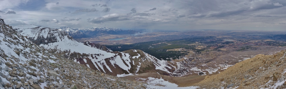
The pleasant panorama from our safe snack spot. In the center of the photo you can see smoke from the prescribed burn that foiled our original (more puppy-friendly) plans. Click to see larger.
.jpg)
Looking beyond Nugara’s “northeast ridge” towards Lower Waterton Lake and the Red Rock Parkway beyond.
.jpg)
Mount Blakiston (left) and Mount Anderson (right) tower above Mount Crandell (center). Ruby Ridge is also visible on the far left below Blakiston.
.jpg)
Zooming in towards the peaks of the Red Rock Parkway: Bellevue Hill (center foreground) rises up from the prairies. Above Bellevue, a long ridge stretches between Mount Galwey (center left) and Mount Dungarvon (center right).
.jpg)
The prescribed burn smolders at the base of Lakeview Ridge.
.jpg)
It’s not the customary summit selfie but, on this day, it will have to do.
.jpg)
My disappointment at not reaching the summit was eased when I decided to take advantage of this SPECTACULAR 300 vertical meter glissade! The snow was just hard enough to get some real good speed while being soft enough to stay in control. I descended this gully so fast that my ears actually popped!
.jpg)
These sheep briefly looked up as I whooped and hollered my way down the snowy mountain on my butt. By the time that I got my camera out, they’d seen enough and went back to their meal though.
.jpg)
Crux pauses to pose amongst big terrain in the cirque.
.jpg)
Still lots of snow (and avalanche hazard) on the cirque’s more sheltered east-facing aspects.
.jpg)
Back in the cirque, Crux and I enjoyed one final glissade as peak gave way to prairie.
.jpg)
Looking forward to a thrash/post-hole combo on deproach. I’d really like to come back (sans dog – sorry Crux) to enjoy the scrambling up high on Sofa but am not all that keen to repeat this approach…
.jpg)
Looking back towards the “butt track” left behind following a spectacular glissade. Mouse over to see the glissade highlighted and to see where Crux and I turned around (star).
.jpg)
Somehow I ended up on the opposite (more scenic) side of this pond on our way down. Click to see larger.
.jpg)
A very snowy Vimy Peak rises up to the west of the pond.
.jpg)
Stopping to smell the flowers near the trailhead.
.jpg)
There are signs of spring down below but it is still winter above (unfortunately)…
Crux and I might not have got up the peak we wanted (or even got up a peak at all) but it was still great to spend the day in the mountains with my former “fur baby”!
.jpg)
.jpg)
.jpg)
.jpg)