Elevation: Gravenstafel Ridge - 2391 m, Mount Haig - 2610 m
Elevation Gain: 1510 m (cummulative)
Located in the heart of Castle Provincial Park, the Castle Ski Resort occupies the eastern slopes of Gravenstafel Ridge. Gravenstafel Ridge was officially named in 1958 to honor the Belgian ridge that bears the same name. The original Gravenstafel Ridge is one of the highest points in the Flanders area. As such, it was the site of many battles during the First World War, including the Second Battle of Ypres. This battle spanned 34-days and marked the first time that a Colonial Force (the First Canadian Division) defeated a European Power (the German Empire). Alberta’s Gravenstafel Ridge was named to honor the efforts and sacrifices of the Canadians who bravely fought there. Mount Haig is located on the Continental Divide and is one of the highest peaks in Castle Provincial Park. The peak was named for Captain Robert Wolseley Haig. Haig served as Chief Astronomer and Senior Military Officer for the British North America Boundary Commission between 1858 and 1862. This Commission sought to establish the official boundary between Canada (then British North America) and the United States. The Commission’s efforts included surveying, cutting wide swaths of timber and marking the border along the 49th parallel as agreed upon in the Treaty of Oregon.
My Ascents:
July 9 2020
Trailhead: Castle Mountain Ski Resort GPS Track: Gravenstafel Ridge and Mount Haig
Summer is cruelly short in the Canadian Rockies and as June turned to July, I began to feel the familiar, mounting pressure to climb – well, a mountain. Realistically, peak scrambling season lasts anywhere from 60 – 90 days during an average year (and at least half of those days are likely to be spoiled by moody mountain weather). As I foolishly scanned my social media feed, my FOMO grew more acute as Facebook friends tagged peak after spectacular peak. Between camping and kiddie hikes, I too had enjoyed a reasonable number of outings but hiking with the kids doesn’t alleviate the stress of dealing with said kids!
Speaking of stress, work was something else this year. I know that I should be happy to have a job during a pandemic but I’ve started to feel crushed by its increasing demands. As the pressure of working from home continued to mount, I even began to feel tightness in my chest. When an impromptu trip to the ER revealed that I was in fine cardiac health but stretched beyond my limits, it became increasingly apparent that I NEEDED a mountain day. And so, with the encouragement of my wife, I got the hell out of Dodge on Thursday July 11.
After reaching out to a few old scrambling partners, I was pleased when the ever-fashionable Professor Clay agreed to join me (Matt pretty much never says “no” to a scrambling invite). Matt and I excitedly discussed all sorts of adventurous peaks to target but, as our weather window dramatically slammed shut, we were forced to cast our gaze to the far southwest corner of the province where clearer skies were forecast. Matt suggested a two’fer that would involve a long day with a healthy “dose of bushwhacking and rubble” but the promise of suffering held uncharacteristically little appeal (this may be the first time that I’ve ever said “no” to bushwhacking). With our plans as tenuous as the forecast, I mentioned that Gravenstafel Ridge and Mount Haig were on my radar. I’d hiked to Paradise Lake Tarn with my family earlier this month and Haig (which towers almost 800 vertical meters above) caught my eye then. I figured this suggestion might spell the end of our July 9 plans since Matt had already climbed both of those peaks on separate occasions. To my great surprise, however, he decided to join me for a rare repeat (x 2)! And so, 30-minutes before the sun was set to rise, we set off to Castle Wildland Provincial Park to destress with a cumulative elevation gain of over 1,500 vertical meters!
And they say chivalry is dead! After graciously chauffeuring me to the trailhead at the Castle Ski Resort, Matt even held the ropes that delineate the parking area up for me! While these gestures briefly put him in my good graces, he quickly wasted the positive capital that he’d accrued by charging off up a ski run that was nowhere near where we were trying to go (this despite the fact that he’d hiked up the correct route previously)! After “warming up” with 100 vertical meters that were completely unnecessary, we hiked back down and found the obvious, gently angled road that leads up Gravenstafel Ridge near the confluence of 2 chairlifts and a T-bar.
LEFT: Matt enjoys easy hiking through lush terrain on an absurdly obvious road.
RIGHT: A small but scenic creek trickles down from Gravenstafel’s false summit.
One of the benefits of hiking up ski areas is that their wide-open runs grant great views! Here Matt enjoys a breather while taking in the view of the verdant West Castle Valley.
The downside of hiking up ski areas, however, is the litany of unnatural infrastructure and detritus than can distract from, what would otherwise be, beautiful mountainside. In this instance, however, the lifts and fences were a small price to pay for the gently angled road that allowed us to gain 980 vertical meters with ease. While this sort of gain usually requires serious huffing and puffing, on this day, Matt and I were able to chat all the way to the top (of the first peak anyway).
LEFT: As the road gains Gravenstafel’s north ridge, the summit comes into view ahead and the prevalence of unsightly ski infrastructure dwindles.
RIGHT: Rock outcrops along Gravenstafel’s north ridge spectacularly frame this lush outlier of St. Eloi Mountain to the west.
Looking back at the gentle winding path that our ascent road followed.
At the top of the highest lift, the “Chutes Gate” leads to experts-only terrain. This gate normally serves as a portal to double-black-diamond adventures but, on this day, it framed our ultimate destination: Mount Haig. Beyond the gate, the main road descends (as ski runs tend to). A smaller side road, however, continues up to and beyond the explosives shack on the right.
Beyond the KABOOM shack, the side road is less distinct but still easy and obvious to follow as it continues to switchback up towards Gravenstafel’s summit.
After a couple of long switchbacks, the side road finally ran its course and deposited us a few vertical meters from the summit. Despite the lack of road from this point on, the going remained delightfully simple. In fact, I would highly recommend the hike up Gravenstafel for anyone fit enough to manage the 13-km return and 980-m gain.
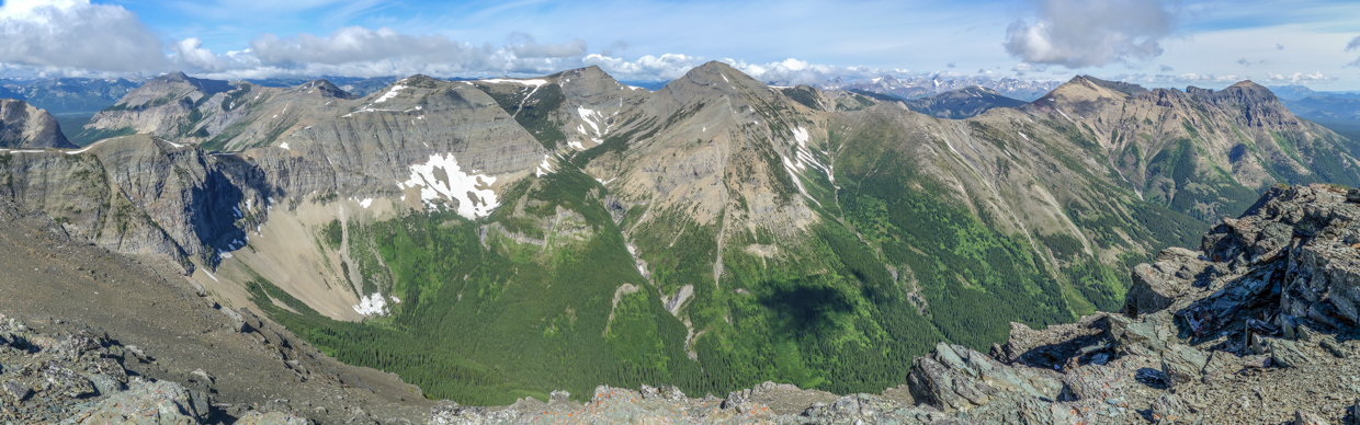
The spectacular summit panorama to the west provided an immediate return on our sweat investment! Talk about a great way to destress! Click to see larger.
Looking west towards Packhorse Peak on the other side of the Continental Divide.
LEFT: The view towards nearby St. Eloi Mountain is breathtaking. Surely this is a peak to scramble on a nice day (eh, Matt?).
RIGHT: Mount Darrah presides over the lesser peaks of the Flathead Range to the northeast.
The northern reaches of the Flathead Range include (from left to right): Mount McGladrey, unnamed, Andy Good Peak and Mount Coutlhard.
To the north, Syncline Mountain’s characteristic shape befits its name.
Syncline Mountain (left) and Southfork Mountain (right) bookend Highway 774 which grants access to the spectacular West Castle Valley. Click to see larger.
A pair of physically distanced scramblers practice their matching “Matt” summit poses atop Gravenstafel Ridge!
A plethora of named foothills sit between the peaks and the prairies to the northeast.
Centre Peak is the highest point of the distant Livingstone Range which rises up beyond Syncline.
To the east, the Southfork Mountain/Barnaby Ridge massif is highlighted under harsh summer lighting.
Gravenstafel Ridge stretches south towards massive Mount Haig. Click to see larger.
Jake Smith Peak is the highest peak in the area. Despite the forecast which called for next-to-no cloud, we’d noted unusual fluffy cloud caps on many of the higher peaks to the south.
Looking on with anticipation at the road ahead! After a 30-minute summit stay, we decided to resume our adventure and continued south towards our ultimate objective: Mount Haig. Photo courtesy Matt Clay.
LEFT: As we scrambled south towards the Gravenstafel-Haig col, Haig Lake was spectacularly revealed in the valley ahead. The summit view from Gravenstafel was outstanding but it’s a pity that this vibrant lake isn’t visible from there. In my opinion, it’s worth it to scramble a short distance south from the summit just for this view!
RIGHT: Matt carefully navigates one of the many small rock bands that separate Gravenstafel from Haig. Fortunately, all of these bands could be easily scrambled or by-passed.
A glance back towards Gravenstafel provides an indication of the easy scrambling that its south ridge offers.
Mount Haig towers dramatically above its spectacular, namesake lake. From here, our route continued along the foreground ridge (right) to the intervening col, then up steep, scrambly terrain to Haig’s shoulder (right) and onwards up its mellower skyline ridge. In his guidebook, Nugara recommends that Haig be descended this way but doing so would put this view at your back rather than in front of you!
LEFT: A closer look at the steep terrain above the col. Despite its fearsome appearance, a moderate scrambling route follows the nose of the ridge up, with small detours to the climber’s left (east) on occasion.
RIGHT: Sheets of wind-hammered snow had recently broken free from Haig’s steep north face.
LEFT: On those rare instances when Haig Lake wasn’t adding a splash of color to the scene, colorful lichen-covered rocks and yellow cinquefoil stepped up to the plate to do so.
RIGHT: Cinquefoil.
Nearing the col, we spot another pair of “scramblers” (on a green patch in the center of the photo).
GOATS!!!
Arriving at the col, we found ample evidence that it's a popular spot (for goats anyways). With the arrival of warm summer days, our furry friends had used many of the col’s trees to rub and rid themselves of their thick winter coats.
LEFT: After a quick snack at the goat fur-covered col, we decided to tackle the day’s crux: the ridge up towards Haig’s west shoulder.
RIGHT: Matt “enjoys” some hands-on scrambling between a pair of pinnacles just above the col.
LEFT: Matt works his way up slippery, pebble-covered ledges hoping not to tumble into Haig Lake. The terrain above the col really wasn’t too difficult but Matt found himself a little “gun-shy” following a close call on a nearby peak a few weeks earlier. He even mused aloud that his earlier slip may have ruined his ability to scramble on moderate terrain. Fortunately, he eventually found his “scrambling legs” as the day went on (despite his best efforts to side-hill unnecessarily from time to time)!
RIGHT: Matt tops out on Haig’s west shoulder with Gravenstafel and all the hands-on scrambling now behind him.
MORE GOATS!!! Upon reaching Haig’s west shoulder, we noticed a large family using a snow patch to cool themselves on the connecting ridge to St. Eloi Mountain. Despite the fact that it would mean losing (and then regaining) 75 vertical meters, I decided to slowly approach them to see if they’d allow me to take some better photos from a respectful distance. Satisfied with his long-distance view of the goats from the col, Matt opted to sit this one out and enjoyed a snack and a rest while I set off and hoped to blend in with the herd.
Despite my stealthy approach, the goats skillfully escaped, quickly navigating along a sheer rock wall to avoid this 2-legged imposter.
A closer look as the nannies guide their kids across steep, ultra-exposed ledges. Not my idea of a "kid-friendly" hike! (Dad Joke!)
Watching the Rocky Mountains' ultimate scramblers in awe. GOATS ARE AWESOME!!!
After my goat-fueled side-trip, I returned to the shoulder and Matt and I continued up Haig’s slog-of-a-north-ridge. Photo courtesy Matt Clay.
Despite the barren appearance of Haig’s north ridge from afar, the micro-terrain featured several spectacular alpine rock gardens.
A lovely white mountain aven grows out of a clump of colorful moss campion.
LEFT: While it would have been pleasant to spend our afternoon basking in a high alpine rock garden, there was still a pile of scree to climb!
RIGHT: “Up and atom!” Chemist Clay resumes his slog.
Matt ponders the questionable life choices that brought him to this specific scree slope, not once, but twice. Fortunately, the nearby summit provided a view well-worth re-slogging for...
See what I mean?! An precipitous drop to colorful Haig Lake highlights the panorama of the West Castle Valley from Mount Haig’s airy summit! Click to see larger. Photo courtesy Matt Clay.
LEFT: Marveling at Haig Lake’s cerulean surface from 800 vertical meters above. And wait a minute…are there more GOATS on a ledge WAY down there?!
RIGHT: GOATS GOATS GOATS!!! As the day went on, it really seemed like we couldn’t look at Haig’s sheer north face without spotting precariously perched mountain goats somewhere upon it!
Syncline Mountain, Gravenstafel Ridge and Southfork Mountain tower above the nearby foothills and the vast prairie beyond.
A closer look back at Gravenstafel shows how much higher its summit is than the highest of the ski hill infrastructure. As a consequence, you really don’t feel like you’re on a ski hill while you’re atop it. The downside, however, is that this means you still have a decent way to go once you reach the top of the lift/explosives shack (right).
Monstrous wind and canola farms proliferate on the prairie beyond the colorful summit of “the Amoeba” (an unofficial high point which separates Southfork Mountain from Barnaby Ridge).
To the east, the higher peaks of the East Castle region appear beyond the Southfork-“Amoeba”-Barnaby massif while much smaller Haig Ridge can be seen in the foreground.
Having hiked to Paradise Lake Tarn a few weeks earlier, I was disappointed that it was not visible from Haig’s summit so I ventured a fair ways (losing more elevation than I hoped to) to spot it. As you can see, this snowy, muddy puddle wasn’t really worth the 20 minutes that it took me to scramble to and from this vantage point east of (and well below) the summit!
Victoria Peak (left), Castle Mountain (center) and Windsor Peak (right) are some of East Castle’s most recognizable peaks.
Not to be outdone by the views to the north and east, the panorama to the south and west was equally spectacular. While Haig Lake’s brilliant blue color was absent in this direction, the lush, green hanging valleys below and reddish rocks above provided more than enough color to qualify as aesthetic! Click to see larger.
Lys Ridge (center left) and Rainy Ridge (right) highlight the view southeast towards Waterton National Park.
Mounts Blakiston (center left) and Cleveland (right) are the highest peaks in neighboring Waterton and Glacier National Parks, respectively.
A sea of peaks (named and otherwise) to the south. Surprisingly, the impressive peak in the foreground is, to my knowledge, unnamed! In the middle ground, the trio of Jake Smith Peak, Scarpe Mountain and Langemarck Mountain is obvious at center.
Looking west into beautiful British Columbia. Click to see larger.
Boot Hill and Tombstone Mountain highlight the view to the southwest.
To the west, Mount Doupe, Mount Swope and Overfold Mountain are among the more impressive peaks of the Macdonald Range.
After feeling crushed by responsibilities only a short time ago, it was amazing to feel light again atop Mount Haig! Photo courtesy Matt Clay.
The Continental Divide follows the connecting ridge towards nearby St. Eloi Mountain before continuing north and west along the sun-kissed Flathead Range.
Mount Darrah’s vertiginous peak is unmistakable from anywhere in the area.
Beyond Mount McCarty, Mount McGladrey, unnamed, Andy Good Peak and Mount Coulthard stretch north towards the Crowsnest Pass.
After a lengthy summit stay, Matt and I quickly snapped a pandemic summit photo before starting our descent.
LEFT: He who grovels up treadmill scree, gets to enjoy a delightful downhill scree run on descent.
RIGHT: Unfortunately, the descent from Haig’s shoulder to the Haig-Gravenstafel col proved less delightful. Although it's not exposed, much of this section featured small, loose rock atop larger rock steps. In essence, it reminded me of walking down my stairs after my girls have left all their little toys on them. An awkward descent followed but, unlike the toys on my stairs, the pebbles here failed to launch me a$$ over tea kettle.
After reaching the col, Matt and I opted to descend to Haig Lake and hike out via the Haig North hiking trail. To my great surprise, the descent from the col proved to be the most difficult part of the day! Steep terrain here conspired to hide cliffs lower down. Fortunately, Matt had been here previously and remembered the best way down; this involved steep and awkward side-hilling on hard-packed dirt and grass to the skier’s left before, eventually, escaping down a lovely scree chute.
LEFT: After seriously questioning Matt’s route-finding skills during our unpleasant side-hill, the method to his madness became apparent at the top of this conveniently placed scree run.
RIGHT: Matt exploits perfect scree to quickly lose elevation from the col, reaching the alpine meadows above Haig Lake in a few short minutes.
LEFT: Mount Haig towers above flowering bear grass at the head of the Haig Lake Valley. We briefly debated the merits of adding the hike to Haig Lake to our day’s itinerary but, ultimately, decided to continue our descent hoping that this course of action would have us back in Calgary in time for dinner with our respective spouses.
RIGHT: Beautiful bear grass.
LEFT: With its bear grass-filled alpine meadows and views towards Southfork Mountain, the Haig North trail proved to be an extremely pleasant way to end our Castle Wildland escape.
RIGHT: Enjoying the little things, like this crisp, clear cascade, on the hike down.
Only 45-minutes after we set off down the Haig North trail, we found ourselves back at the ski resort where empty cabins marked the end of our adventure.
As we drove home through scenic foothills, I felt like the weight of the world had been lifted from my shoulders. For me, mountains aren’t just an escape; Mountains are restorative; Mountains are medicine.
.jpg)
.jpg)
.jpg)
.jpg)
.jpg)
.jpg)
.jpg)
.jpg)
.jpg)
.jpg)
.jpg)
.jpg)
.jpg)
.jpg)
.jpg)
.jpg)
.jpg)
.jpg)
.jpg)
.jpg)
.jpg)
.jpg)
.jpg)
.jpg)
.jpg)
.jpg)
.jpg)
.jpg)
.jpg)
.jpg)
.jpg)
.jpg)
.jpg)
.jpg)
.jpg)
.jpg)
.jpg)
.jpg)
.jpg)
.jpg)
.jpg)
.jpg)
.jpg)
.jpg)
.jpg)
.jpg)
.jpg)
.jpg)
.jpg)
.jpg)
.jpg)
.jpg)
.jpg)
.jpg)
.jpg)
.jpg)
.jpg)
.jpg)
.jpg)
.jpg)
.jpg)
.jpg)
.jpg)
.jpg)
.jpg)
.jpg)
.jpg)
.jpg)
.jpg)
.jpg)
.jpg)
.jpg)
.jpg)
.jpg)
.jpg)
.jpg)
.jpg)
.jpg)
.jpg)
.jpg)
.jpg)