Summer heat waves are unpleasant. Summer “heat domes”, on the other hand, are unbearable. The hot is bad enough but stagnant hot for days on-end is truly awful. Typically, my response to extreme heat is to seek natural air conditioning. Temperatures drop as you go higher and higher – it’s science. If that means that you have to find a glacier or bag a summit to escape the heat, then so be it! So, with Western Canada literally cooking under a “heat dome”, I reached out to the like-minded Matt Clay to see if he was interested in climbing until tolerable temperatures could be reached. Matt C. was, of course, game and we quickly settled on Big Bend Peak, hoping that its proximity to the Columbia Icefields would beat the literal heat while bringing the figurative heat 🔥 in terms of glacier-filled vistas.
Setting out from Calgary in the morning’s wee hours, we enjoyed our first carpool in over a year (thanks to recent COVID vaccinations). The in-car company was especially welcome since our commute to the “Big Bend” required 3.5 hours! After much catching up, we reached said “Bend”, turned around where it was safe to do so and parked at the correct roadside pullout (the one that doesn’t require a ford of the North Saskatchewan River).
.jpg)
.jpg)
LEFT: Talk about “bringing the heat!” From the correct pullout, the roadside view of Big Bend Peak above the nascent North Saskatchewan River provided plenty of inspiration to get this show on the road (mind the nearby hairpin though).
RIGHT: By parking where we did, we were able to take advantage of an 88-year-old bridge to cross the North Saskatchewan (which falls dramatically into a thin chasm immediately below). An alternative pullout at the “Big Bend’s” apex cuts off a little distance (1 km) but requires a ford of the North Saskatchewan River upstream of a waterfall (doesn’t sound brilliant, does it?).
.jpg)
.jpg)
LEFT: A look back at the historic bridge and chasm. In many places, the canyon was probably narrow enough to jump across but you’d REALLY want to make sure that you stuck the landing…
RIGHT: A rainbow fills the, already hot, morning air as the river plunges into the mysterious depths below.
.jpg)
The mouth of the great, unseen waterfall.
.jpg)
.jpg)
LEFT: After cooling off in the unseen waterfall’s swirling mists, we continued upstream along the river’s scenic bank. Just around the riverbend, the route crossed a rocky plain and then followed an old road into the forest.
RIGHT: Sometimes route-finding isn’t rocket science. Suffice to say, the beginning of the old road was well-marked! This road was, apparently, used to bring troops to the nearby glaciers for military training exercises in the early 20th century. Today, it’s mostly used by mountaineers approaching Mount Saskatchewan.
.jpg)
.jpg)
LEFT: After enjoying a km of easy travel, the road descended slightly. Following Nugara’s snowshoe directions, we plunged into the brush at this point and worked our way up the treed ridge.
RIGHT: Despite morning temperatures that were already near 30 C, Matt C. and I gamely thrashed our way up through brush that proved thicker than it initially seemed. At least there was plenty of shade? 😐
.jpg)
After a muggy, buggy bushwhack, we reached more open terrain on Big Bend Peak’s east ridge and were treated to views of the valley below (where once a glacier had been).
.jpg)
.jpg)
LEFT: Matt C. begins to question the life decisions that brought him to this extremely hot point. At least there was snow to cool down a bit now!
RIGHT: Taking advantage of snow (that wouldn’t be there much longer) to ease our uphill trek.
.jpg)
.jpg)
LEFT: As we neared tree line, views towards Mount Athabasca provided much inspiration. While I’d anticipated spectacular views of nearby 11,000ers, the colorful rock and alpine gardens on our ascent ridge proved to be a most-pleasant surprise.
RIGHT: As the ascent angle briefly eased on a colorful alpine bench, we were treated to our first views of spectacular Mount Saskatchewan.
.jpg)
Avens in the alpine.
.jpg)
While Mount Saskatchewan highlighted the view from this alpine plateau, it was Big Bend Peak’s false summit (right) that would truly take our breath away… (click to see larger)
.jpg)
Since the mountain wasn’t going to climb itself, we continued to slog up and prayed for some relief from the heat. Don’t let the snow fool you. It was HOT 🔥 (photo courtesy Matt Clay).
.jpg)
Matt C. tackles a small rock band about halfway up the false summit. Despite the down-sloping nature of the scree-covered ledges here, the scrambling remained easy.
.jpg)
It may look like I’m posing with Mount Saskatchewan but I’m really catching my breath! Kicking steps in + 30 C proved harder than it is in -30 C! Photo courtesy Matt Clay.
.jpg)
Eventually, the slope steepened to the point where travel on snow no longer felt prudent. As the sun mercilessly beat down upon us, we grunted up unrelenting treadmill scree. Atop, we agreed to never speak of this slope again.
.jpg)
While the false summit featured a pleasant panorama (click to see larger), a few things became obvious at this point:
1) The true summit (right) was still some distance away!
2) The steep ascent and extreme temperatures to this point had taken a toll. While I’d been energetic earlier on, I began to feel “off” 🤢 as we crested the false summit.
3) Matt C. and I were both about to run out of water (never a good thing on the way up a peak)…
After some discussion, we decided to continue up with a plan to descend via an alternate route that we hoped would provide access to water. From this point on, we moved slowly and deliberately in an effort to avoid full-on heat stroke.
.jpg)
The impressive North Towers of Mount Saskatchewan taunt this pair of thirsty scramblers with their slopes full of water (if only it was in the liquid state)!
.jpg)
Matt C. continues up towards Big Bend’s sunbaked summit.
.jpg)
Mount Saskatchewan (left) and its “North Towers” (right) were constant companions as we plodded methodically up, up, up.
.jpg)
.jpg)
LEFT: Mount Athabasca looms as cornices all about fail in the extreme heat.
RIGHT: The terrain steepened near the summit block providing compelling photo opportunities. Fortunately, the east ridge remained a “hands-in-pocket” walk; I’m not sure we’d have had energy for much more at this point!
.jpg)
One final “heave-ho” up to Big Bend’s blocky summit.
.jpg)
.jpg)
LEFT: Upon opening the summit register, we discovered that Big Bend Peak was not completely devoid of things to drink! (We also learned that Matt C. doesn’t know what year it is.)
RIGHT: Never one to look a gift horse in the mouth, I happily partook in a summit nip (but stopped short of really slaking my thirst). Sharing a bottle with strangers is probably a pandemic no-no but the register suggested that we were the first visitors of 2021 so … bottom’s up! After a tasty sip, I quickly remembered that Fireball Whiskey also “brings the heat!” 🔥
.jpg)
An icy summit panorama stretching from near-11,000er Mount Saskatchewan (left) to oft-climbed 11,000er Mount Athabasca (right) – click to see larger. Unfortunately, the nearby glaciers and icefields provided no relief on this day. Thanks to the “heat dome”, the air was stagnant with little hint of a breeze. Worse still, the “heat dome’s” warmth extended high into the atmosphere so my usual strategy of climbing until it cools down proved ill-fated. Matt C. and I both carry thermometers that registered temperatures of + 30 C in the shade of the summit cairn!
.jpg)
So much for beating the heat! 🥵
.jpg)
.jpg)
LEFT: Cleopatra’s Needle teeters precariously to the south of Mount Saskatchewan.
RIGHT: Proof that Saskatchewan isn’t always synonymous with “flat!”
.jpg)
Oppy Mountain makes an appearance beyond the Mount Saskatchewan – North Towers of Mount Saskatchewan col. On the left, Saskatchewan’s slopes provide a textbook example where a heat-triggered cornice collapse set off a much larger avalanche which failed at a slope convexity below. I guess it’s a good idea not to linger under cornices when it’s + 30 C!
.jpg)
Impressive views towards the North Towers of Mount Saskatchewan (left) and a, surprisingly, unnamed peak (right).
.jpg)
A closer look at the impressive, yet unnamed (?) peak. To the left of “unnamed”, Mount Spring-Rice is apparent in the distance.
.jpg)
11,000er Mount Bryce towers to the left more proximate “Mount Saskatchewan Junior.” Glaciated Pawn Peak (part of the Chess Group) is also visible to “Junior’s” right.
.jpg)
Castleguard Mountain sits near the upper reaches of the Saskatchewan Glacier while more distant Rook Peak is faintly visible in the hot haze beyond.
.jpg)
A somewhat heat-stroked scrambler takes in the view towards the spectacular Columbia Icefields.
.jpg)
The second-highest peak in the Canadian Rockies: Mount Columbia (center left).
.jpg)
To the west, Mounts Andromeda and Athabasca were an imposing duo.
.jpg)
Mount Andromeda in all her glory.
.jpg)
Mount Athabasca is nearly 700 meters higher than Big Bend Peak. Perhaps the air up there was cooler?
.jpg)
.jpg)
LEFT: Andromeda’s icefall plunges dramatically from the peak’s sheer east face.
RIGHT: Equally impressive falls on the Athabasca massif.
.jpg)
The wondrous panorama back towards the Icefields Parkway (click larger to try to find the “Big Bend” below).
.jpg)
Tangle Ridge (left) and Sunwapta Peak (right) rise up beyond popular Wilcox Pass (center middle-ground).
.jpg)
Nigel Peak is bookended by more distant Sunwapta (left) and Andover (right) Peaks.
.jpg)
Parker Ridge (left middle-ground) may not be as lofty as many of the surrounding peaks but it still towers over the “Big Bend.” Mount Willis (distant center left) and Mount Stewart (distant center right) are among the few named peaks visible in this direction.
.jpg)
Air-conditioned vehicles cruise around the “Big Bend” far below (I wasn’t jealous, I swear).
.jpg)
Looking back over our ascent ridge towards impressive Cirrus Mountain (center).
.jpg)
A closer look at Cirrus Mountain (left) and its impressive unnamed outlier (right).
.jpg)
The Whitegoat Peaks (left) and 11,000er Mount Cline (right) bookend glaciated Mount Coleman to the southeast.
.jpg)
Mount Burwash.
.jpg)
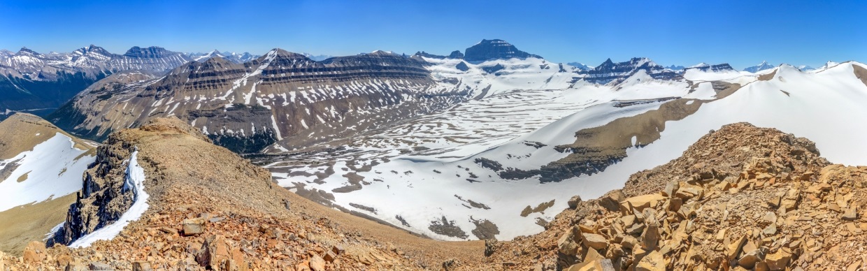
The panoramic view of the impressive glacier-carved valley below Mount Saskatchewan. Click to see larger.
.jpg)
Spine Peak (left) and Mount Saskatchewan (right) tower above the, now, glacier-less valley.
.jpg)
With serious concerns about heat stroke, Matt C. and I didn’t linger long atop Big Bend Peak (despite the spectacular views). After a quick cairn-top self-photo, we started down in the hope that we’d be able to find our way to a creek in the valley below.
.jpg)
Matt C. stuffs his hat (and shirt and pant pockets) full of snow. As the extreme heat radiated off the rocks all around us, this little trick proved to be a lifesaver!
.jpg)
Upon reaching the col between Big Bend’s true and false summits, we started down the scree slopes at right (rather than retracing our bone-dry ascent route).
.jpg)
.jpg)
LEFT: From above, this alternate descent looked to be a simple scree slope with multiple, thirst-quenching creeks below. Matt C. cautioned, however, that unseen rock bands might be present based on his memories of this face from an earlier trip up the valley below…
RIGHT: Initially, we made quick work of our alternate descent thanks to the same treadmill scree that plagued us on the way up.
.jpg)
.jpg)
LEFT: And, as scree turned to snow, the descent got faster still.
RIGHT: All good things, as they say… After enjoying our easy alternate descent, we finally reached the cliff bands that Matt C. had been weary of. Fortunately, these proved relatively easy to find our way down through!
.jpg)
Below the cliffs, an easy glissade was all the remained between us and cool, life-sustaining water. If you’re ever looking for a quick way to cool down, try glissading ass-first into a creek! 🤣
.jpg)
.jpg)
LEFT: After filtering water from the lively, little creek and sating our extreme thirst, we paused to appreciate the splendor of the alpine bench that we’d reached.
RIGHT: Rushing meltwaters disappear back into the snow (from whence they came).
.jpg)
Spine Peak, Mount Saskatchewan, the North Towers of Mount Saskatchewan and Mount Saskatchewan Junior highlight the panoramic view from the spectacular, creek-covered alpine bench. As Matt C. rightly pointed out, this view, reached fortuitously because we’d exhausted our water supply, was likely the day’s best! Click to see larger.
.jpg)
Matt C. pauses to take in the wonderful alpine views before turning his attention to our alternate descent. With water bottles full once more, we followed a northeast-trending alpine bench back towards our ascent ridge. We hoped that this would allow us to avoid bushwhacking in the valley below and Big Bend’s treadmill scree above.
.jpg)
After successfully following the pastoral alpine bench most of the way back to our ascent ridge, we were faced with a brief uphill to regain our original route. While the 40 m climb was less than ideal, it was a small price to pay for filled water bottles!
.jpg)
.jpg)
LEFT: Matt C. easily loses elevation on the day's last snow (after refilling his hat and pockets, of course). Below this patch, we plunged back into the forest to finish our day with a thrash.
RIGHT: Sometimes you whack the bush and sometimes the bush whacks you… 🌲 For some reason, the forest that seemed thin on the way up closed in around us on descent. Perhaps it was the heat. Perhaps it was our exasperated mental state. Whatever the reason, our bushwhack down seemed 10 x more intense than it had on the way up.
Eventually (and mercifully), our plow through the forest reached its end and we reached the old road, then the riverbank and then, best of all, the air-conditioned ❄️ car complete with cold beverages in a cooler! Sipping a “cold one,” 🍺 I watched the North Saskatchewan River plummet into the earth and reflected on the day’s events. While we didn’t beat the literal heat as hoped, Big Bend Peak, unequivocally, brought the scenic heat that we’d hoped for. 🔥 😍
.jpg)
.jpg)
.jpg)
.jpg)
.jpg)
.jpg)