There was a time when my Dad Gord was my scrambling partner of choice. For years, every summer weekend brought us together on some new scree slog. Indeed, the potential for father-son mountain adventures seemed endless back then.
As time passed, however, things changed. I met my wife. I got a job. I had kids. Free time for peak-bagging became rarer and rarer and I became obsessed with “big days” whenever I could escape. As I grew up, Gord also aged. He got a hip replacement in 2017. He had grandkids. He came to appreciate sleeping-in over alpine starts. The idea of a “big day” began to make him anxious instead of excited. We still get out together but the adventurous summits of our past have turned into well-travelled kiddy-hikes. We still talk about grander outings. But, we never seem to find the time…
On August 11, 2021, we decided to make the time. With the encouragement of my wife and the begrudging permission of my boss, I took a day-off; a day for Gord and I to finally enjoy another “big day” in the mountains. Departing Calgary at 5 am, we ventured west in search of an overdue father-son adventure.
.jpg)
.jpg)
LEFT and RIGHT: Sometimes the adventure starts before you even lace your boots! After about 260-km of highway driving, we turned onto a remote forestry service road in the east Kootenays and followed it for over 40-km until we reached a significant washout. After delicately turning around on the steep, narrow road, we parked at the base of a spectacular headwall. Surrounded by fireweed and cascading waterfalls, we geared up for the off-road portion of our adventure!
.jpg)
.jpg)
LEFT: Gord enjoys a wonderful trail (complete with wooden staircases) in the middle of nowhere thanks to the operators of a nearby backcountry lodge. Out of respect for said lodge and its guests, I’ve kept the details in this trip report vague. Hence, it will feature no detailed route description nor will it include a GPS track.
RIGHT: After the trail climbed steeply through lush BC forest, it entered a more open, alpine amphitheater and cleverly weaved its way among the cliffs to “Ptarmigan Plateau” above.
.jpg)
Having gained the plateau, the network of forestry service and skid roads that facilitated our approach was laid out at our feet. The lodge’s secret trail is very well-built but it doesn’t shy away from elevation gain!
.jpg)
.jpg)
LEFT: The star ⭐ of the day: Gord looks happy to be atop the “Ptarmigan Plateau” on another alpine adventure!
RIGHT: The other star ⭐ of the day: unofficially named “Sharkfin Peak” (also referred to as “The Talon”).
.jpg)
White Man Mountain comes into view as the trail meanders more gently up the plateau.
.jpg)
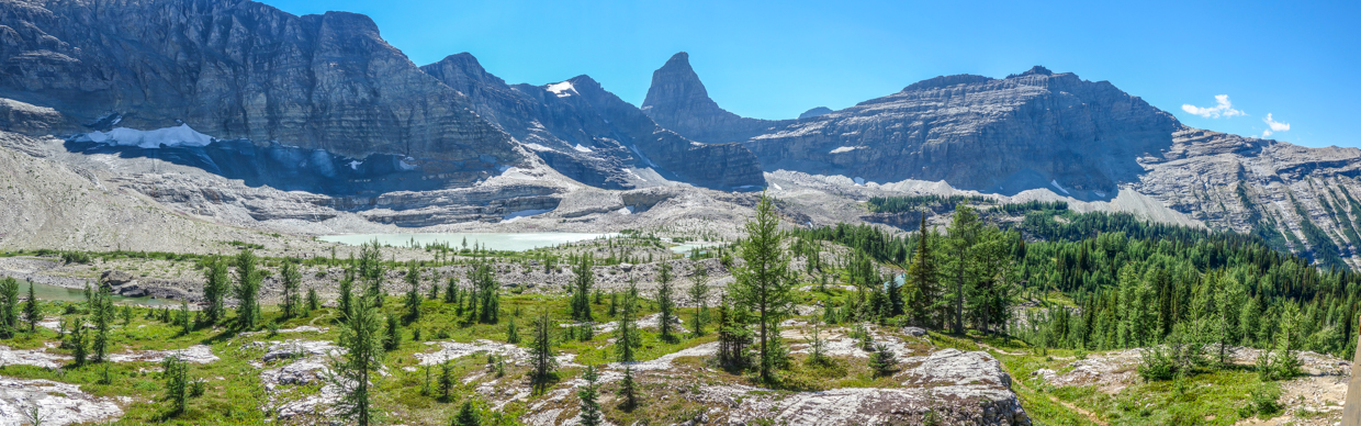
Eventually, the trail dispersed amidst the massive plateau’s infinite possible paths. Click to see larger and soak in the view which stretched from Kananaskis Country (left) to Height of the Rockies Provincial Park (right).
.jpg)
Burstall Pass (middle-ground) was among the Kananaskis landmarks visible to the east. Beyond the popular pass, Mounts Chester and James Walker were also visible.
.jpg)
.jpg)
LEFT: 11,000er Mount Sir Douglas is a highlight from both Burstall Pass and from the “Ptarmigan Plateau.”
RIGHT: Gravity-defying Mount King Albert.
.jpg)
Mounts Brussilof (center) and Alcantara (right) highlighted the view to the northwest as we explored the expansive plateau. With no particular destination in mind, we simply followed our noses towards whatever view looked best.
.jpg)
Clearly, the “follow your nose” strategy paid off! 😍 After a surprising number of ups and downs on the plateau, we stumbled upon this spectacular tarn, nestled below an unnamed triple-summitted peak. To the east and south, the far-ranging panorama included (from left to right): Mount Leval, Mount Birdwood, Snow Peak, Mount Chester, Whistling Rock Ridge, Mount Leman, Mount Sir Douglas, Mount King Albert and Mount Back. Click to see larger.
.jpg)
The little tarn enticed us with its vibrant colors!
.jpg)
Color overload 🤯 and views towards White Man Mountain from the tarn’s vibrant shores. Click to see larger.
.jpg)
A closer look at the river beauty (Chamaenerion latifolium) that really made this alpine scene pop.
.jpg)
Mounts Sir Douglas and King Albert made a fine backdrop for the tarn’s brilliant, wind-whipped waters.
.jpg)
.jpg)
LEFT and RIGHT: Soaking in the scenery! Having stumbled upon one of the prettiest tarns in the Rockies, we stopped for a well-earned snack (and consumed more digital memory than food).
.jpg)
Having whetted our appetites for colorful tarn-filled scenes, we decided to continue our explorations toward the nearby “Jewel Lakes.”
.jpg)
After a few ups and downs along the “Ptarmigan Plateau”, “the Talon” appeared once more beyond a spectacular alpine spring.
.jpg)
.jpg)
LEFT: Did I not mention that the spring was spectacular?! 😍 Check it out! It came right out of a slot in one of the plateau’s Karst rock walls!
RIGHT: Evergreen mosses spring forth from the spring.
.jpg)
.jpg)
LEFT: As we wandered towards the “Jewel Lakes”, we passed by the plateau’s lovely backcountry lodge (whose operators built the trail that brought us to these amazing alpine environs).
RIGHT: Not wanting to disturb the guests, staff or operators, we initially gave the little lodge a wide berth. When a friendly figure appeared on the deck to greet us, however, we aborted our detour and decided to be sociable.
The figure in-question turned out to be Heidi, the lodge’s chef. We’d been worried that the lodge might not be keen at the prospect of (non-paying) visitors in their “backyard” but Heidi’s wonderful welcome quickly convinced us otherwise! Far beyond a quick “Hello”, she invited us in for a tour and a chat. She even donated provisions to keep our energy levels up! It seems that day-trip hikers remain a rarity here! I believe Heidi’s exact words were: “I don’t think this has ever happened before!” (Of course, it had happened before – at least once).
.jpg)
The magnificent view from the lodge’s panoramic deck (click to see larger). As we enjoyed a brief rest and Heidi’s company here, I began to press her for beta on the surrounding peaks (I’m hopeless, I know). While “the Talon” steals the show, I learned that the ridge at left is referred to as “Royal Ridge,” that the pointy peak immediately left of “the Talon” is called “Angel’s Peak” and that its prominent shoulder (immediately in front of the “Talon”) is called “Eagle’s Landing.” While we hadn’t set out with any particular peak in mind, the knowledge that “named peaks” were nearby focussed our efforts towards a goal. Having already hiked for almost 6-hours (and with a 4-hour drive home still ahead), we settled on the most “modest” of the nearby peaks and set off on the next stage of our father-son adventure!
.jpg)
.jpg)
LEFT: Passing by the first of the “Jewel Lakes” en route to “Eagle’s Landing.” These beautiful tarns are the result of several not-long-for-this-Earth glaciers (like this one nestled at the base of Royal Ridge).
RIGHT: Lodge-crafted “bridges” assisted with the crossing of the lakes’ various outlet streams.
.jpg)
.jpg)
LEFT: Despite the hardpack glacial debris everywhere around the tarns, colorful wildflowers continued to be prolific!
RIGHT: Another one of the “Jewel Lakes” shimmers in the late-afternoon sun.
.jpg)
Small glaciers give rise to the highest (and most colorful) of the “Jewel Lakes.”
.jpg)
.jpg)
LEFT: “Angel’s Peak” (left), “the Talon” (center) and “Eagle’s Landing” (right) tower above the tarn.
RIGHT: A closer look at Angel’s Peak. With its dying glaciers and lively cascades, this beautiful peak would probably get more attention were it not for its even-more-striking neighbor.
.jpg)
“Eagle’s Landing” (center) started to look more impressive as we rounded the tarn and ascended the moraine beside it.
.jpg)
.jpg)
LEFT: Following the path of least resistance up into the valley between “Eagle’s Landing” and “the Talon.”
RIGHT: Gord follows a faint trail up the moraine as expansive views towards White Man Pass (left) and Mountain (right) open up to the north.
.jpg)
What remains of the glacier that carved this magnificent peak. While this glacier is obviously dying, it’s far from benign! Covered in monstrous boulders and littered with crevasses, there’s danger from above and below here. Mouse over for a better look.
.jpg)
It’s been a while but it looks like Gord still enjoys a good scree slog! Fortunately, the grind up the backside of “Eagle’s Landing” was brief and we topped out after a quick huff-and-puff.
.jpg)
THE EAGLE HAS LANDED! 🦅 As you might expect “the Talon” dominates the panorama from the “summit” of “Eagle’s Landing.” It is, however, far from the only thing to see with panoramic views over the Cross River Valley, White Man Pass and the “Jewel Lakes.” Click to see larger.
.jpg)
.jpg)
LEFT: “The Majesty!” 👑 🤣
RIGHT: A closer look at “the Talon’s” impossibly vertical peak.
.jpg)
“Eagle’s Landing” sports spectacular views and a laid-back summit meadow which makes for fine seating, napping, photography, whooping and yodeling.
.jpg)
Looking north towards Mount Assiniboine (center) and a few of its neighbors: Aye Mountain (left), Eon Mountain (center left) and Terrapin Mountain (center right). Mount Gloria’s ambiguous summits can also be faintly distinguished immediately in front of Terrapin.
.jpg)
While “the Talon” was unquestionably the highlight of the view to the west, the “Jewel Lakes” did their best to rival it to the east.
.jpg)
Red Man Mountain’s scarlet summit (center) highlights the view over the Cross River Valley and White Man Pass.
.jpg)
White Man Mountain’s true (left) and east (right) summits rise up on the other side of the “Ptarmigan Plateau.”
.jpg)
Panoramic views stretching from the “Ptarmigan Plateau” (left), over the “Jewel Lakes” (center) and on up to “the Talon” (right). Click to see larger.
.jpg)
.jpg)
LEFT and RIGHT: A closer look at the “Jewel Lake’s” brilliant blues.
.jpg)
Enjoying some of the provisions 🍪 that the lodge donated to our cause – thanks Heidi!!!
.jpg)
From whence the cookies came!
.jpg)
“Angel’s Peak” rises up immediately to the south. If we had more time, we would have certainly explored that way but it was already 5 pm (and we’d started our day in Calgary at 5 am and still needed to get all the way back). Next time, we’ll just have to start earlier! 🙃
.jpg)
.jpg)
LEFT: An impressive waterfall cascades down “Angel's Peak’s” north face towards the shimmering tarn below.
RIGHT: The source of the waterfall: another remnant glacier.
.jpg)
The wonderful view towards “Eagle’s Landing’s” loftier neighbors.
.jpg)
After gorging ourselves on scenery and lodge cookies (both of which were phenomenal), we set up for a quick summit photo (or two – mouse over to see the “Captains” of “Eagle’s Landing”).
.jpg)
.jpg)
LEFT and RIGHT: Final “fin”-filled views 🦈 before beginning our long retreat back to the forestry service road below.
.jpg)
After a knee-jarring moraine descent, we found ourselves back at the tarn below “Eagle’s Landing” in short order. While we needed to make haste, panoramic views like this conspired to slow us down. 📷 Click to see larger.
.jpg)
While the day dawned windy and cool, the breeze abated in the afternoon and the hot sun ☀️ baked the glacial moonscape. If only there were some way to cool off…
.jpg)
.jpg)
LEFT: Gord goes for it in the highest tarn’s glacial waters. Mouse over to get an idea as to how cold they were… 🥶
RIGHT: Champion of the 73-year-old Polar Plunge division.
.jpg)
A refreshing conclusion to the day’s adventure. Now there was just the small matter of getting all the way back down before dark!
.jpg)
Larches, lodges and lakes. Click to see larger.
.jpg)
.jpg)
LEFT: A colorful crossing at the base of “Royal Ridge.”
RIGHT: Wandering back across the “Ptarmigan Plateau” (and remembering just how expansive it is and how many ups and downs it has!).
.jpg)
A pleasant farewell 👋 from the lodge awaits those who reach the plateau’s end.
.jpg)
Hazy late evening views from the lip of the plateau back down towards the forestry roads below.
.jpg)
.jpg)
LEFT and RIGHT: With daylight beginning to fade, we made haste down the secret trail, hoping that we could, at least, be off the remote forestry service roads before nightfall.
.jpg)
Alpenglow on "the Talon".
.jpg)
.jpg)
LEFT and RIGHT: After making it back to the valley at dusk, we retrieved an ice-cold (and blessedly-caffeinated) Coke from the Cross River while the day’s last rays illuminated the peaks around us. It was now 8:30 pm and a 4-hour-drive lay ahead. We’d hoped for a “big day” and our scenic adventure on “Eagle’s Landing” certainly delivered on that front. Around 12:30 am (19.5-hours after we set out), a road-weary pair of “eagles” “landed” in Calgary (and promptly went to bed 😴 💤 😂)!
.jpg)
.jpg)
.jpg)
.jpg)
.jpg)
.jpg)
.jpg)
.jpg)
.jpg)
.jpg)
.jpg)