Times flies. For Mera’s 5th birthday party, we discovered that a weekend at the Kananaskis Mountain Lodge costs about the same as your typical 1 – 2 hour-long kids’ birthday party. Our kids LOVED the Lodge’s “Beaver Waterpark” and we found the weekend of family-time VASTLY preferable to entertaining a horde of birthday cake-fuelled children! And so, a new tradition was born. As Mera’s 6th birthday 🍰🎈 approached, we, therefore, made reservations for a repeat trip to Kananaskis’ “Beaver Waterpark” (aka the Kananaskis Mountain Lodge).
While hotel check-in wasn’t set until 4 pm, we decided to make the most of our family weekend in the mountains and left Calgary at 8:30 am. During our drive west, the kids amused themselves by “reading” books (including one espousing “The Value of Tenacity” which would prove apt). By 10 am, we found ourselves in the Lodge parking lot with 6 hours to go before our scheduled check-in. Fortunately, I had no shortage of “ideas” 💡 to keep us busy until then…
For better or worse, the most convenient of these ideas was the Mount Kidd Fire Lookout (whose trailhead was literally at the Lodge’s parking lot)! Going into the hike, I knew that this “idea” would be: short (8 km return), steep (620 vertical meters!), scenic and likely challenging for our 6-year-old birthday girl and her 4-year-old sister. Not all ideas are good ones but we were already parked there… 🤷♂️ And so, we set off on an uncharacteristically warm fall morning, hoping for the best (a switchback or two to make that elevation more manageable) and ready for the worst (a slog beyond our kids’ abilities). Either way, it looked like we’d be reinforcing our kids’ reading material with a lesson in tenacity!
.jpg)
.jpg)
LEFT and RIGHT: Setting off from the most southerly of the Kananaskis Village’s parking lots, Mount Kidd loomed impressively overhead. Despite the fact that our destination lookout was due west of the parking area, we followed an established trail network which went south for a reasonable distance before turning back north towards the more rugged lookout trail. There’s at least one road that looks to go more directly towards the lookout but (spoiler alert) it dead-ends before getting there. The trail network can be somewhat confusing, however, it is well-marked and the directions can be summed up as follows:
• Go south on the Terrace/Kovach trail.
• Follow Kovach to the north when it splits off from Terrace (which continues south).
• Stay on Kovach at the next junction and continue uphill for a short distance.
• Keep an eye out for a cairn/flagging/a decent trail that sets off uphill from Kovach.
.jpg)
Happy hikers enjoying a sunny 🌞 fall morning on the Kananaskis Village’s labyrinth-like trails! How lucky am I that the birthday girl wanted to hike with her Dad on her big day? 🥰
.jpg)
.jpg)
LEFT: After about 30 minutes of easy hiking, we spotted a flagged and cairned side-trail and started our adventure in earnest.
RIGHT: As we ascended the side trail, it was obvious that it was much steeper than the old roads/cross-country trails we’d been following. As you can see, the birthday girl even managed to sneak some scrambling in where small rock bands intersected the path. We felt this was on the edge of our kids’ abilities but provided them with a solid “spot” as they climbed and continued up. It certainly couldn’t get any steeper, could it? 😕
.jpg)
The thing about this trail was: just when you thought it couldn’t get any steeper, it did! 😱 As we broke out of the woods and onto more open grass slopes, we became more and more concerned about our kids’ abilities to handle the increasing ascent angle.
.jpg)
.jpg)
LEFT: The birthday girl and her Mom tackle a 38% slope! Worse still (as though the slope wasn’t bad enough on its own), the trail’s dry dirt/loose rock mixture provided very poor footing. For perspective, it took us longer to cover 400 meters distance on this slope than it had to cover nearly 2 km on the approach trails below. A turnaround was very seriously discussed but we fell victim to a sort of “frog-in-hot-water” 🐸☕ dilemma. We kept thinking that the worst was behind us only to forge up a still steeper, still looser section! In the end, the slope provided us all with a lesson in the value (and stupidity) of tenacity!
RIGHT: After an unrelenting stretch that literally went STRAIGHT UP, the trail took a hard right and, mercifully, switch-backed to the lookout’s gentler north ridge.
As an aside at this point: I would not recommend this trail for young children. This section was viciously TFS and the footing was poor. We got away with it because each of our kids had a very experienced adult hiker to “spot” them the whole way up and down. That 1:1 kid to adult ratio proved key! Our 4-year-old did the whole thing on her own 2 legs but we literally held her hand the entire way to keep her from tumbling. Our 6-year-old was more stable but still needed A LOT of help. Like I said, not all “ideas” are good ideas…
.jpg)
.jpg)
LEFT: After gaining the ridge, the trail turned back to the left and followed the forested crest up. It only lasted for a few moments but it felt AMAZING not to have to hold our kids’ hands! Normally, a steep slope would have legs burning with lactic acid but this one had Brianne and I's arms and shoulders crying out for mercy!
RIGHT: The north ridge which, at first, seemed gentle, eventually steepened and its combination of northerly exposure and increasing elevation resulted in snow ❄️ beginning to accumulate (which did little to help with footing). Again, a 1:1 ratio of experienced adults to kids made continuing feasible.
.jpg)
After a SERIOUS slog, the angle abruptly abated and the forest thinned. The top seemed to come out of nowhere (to our collective delight) and a spectacular view of Mount Kidd 😍 (above its namesake lookout site) was the reward for our tenacity/stupidity!
.jpg)
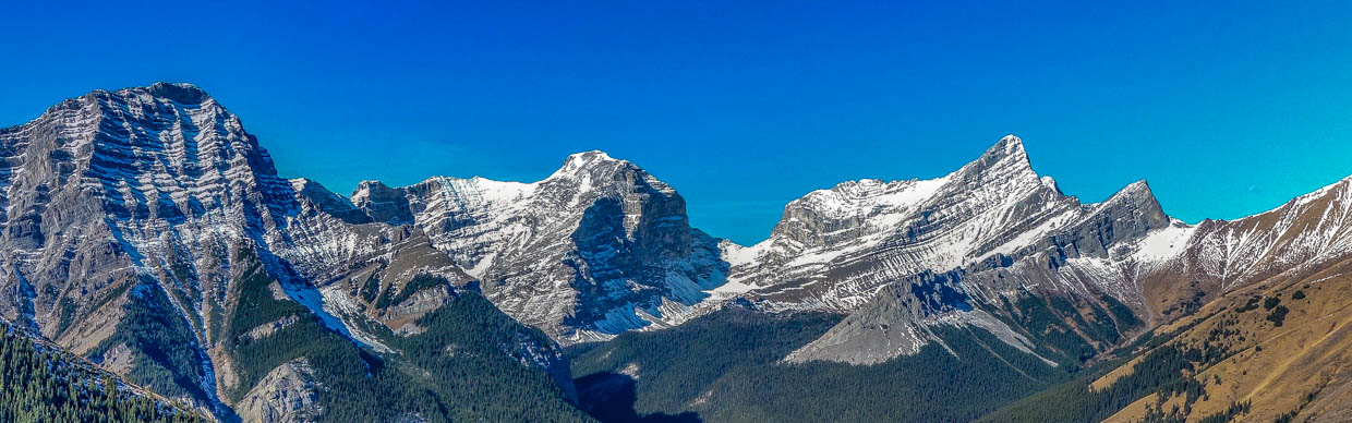
An impressive panorama of the Kananaskis Range greets those who suffer their way up to this former lookout site. Click to see larger.
.jpg)
.jpg)
LEFT: The birthday “Kidd” 🎈 and “her mountain” atop the lookout. We made it but it certainly wasn’t “Kidd-friendly!” 😂
RIGHT: A closer look at nearby Mount Kidd’s towering north face.
.jpg)
The rest of the Range. From left to right: Mount Bogart, Ribbon Peak, Mount Sparrowhawk and Wind Mountain high above the Ribbon Creek Valley.
.jpg)
.jpg)
LEFT: Mount Bogart is the second highest peak in the range and was as fun to climb as it was spectacular!
RIGHT: Ribbon Peak will probably never see a visit from me but the Memorial Lakes behind it are a tempting target.
.jpg)
Attempting (in vain) to get a nice family photo atop. Sigh – “Kidds!” 🙄
.jpg)
.jpg)
LEFT: Nearby Mount Sparrowhawk is a beauty peak and another old favorite.
RIGHT: Speaking of beauty – check out perfectly pyramidal Wind Mountain.
.jpg)
A little further to the east, Mount Allan, Olympic Summit and Mount Collembola provide grassier (but no less spectacular) alternatives to the sheer limestone faces of the Kananaskis Range.
.jpg)
.jpg)
LEFT and RIGHT: It was hard not to smile 😁 on a mid-October afternoon this sunny 🌞 and warm! What a difference a year makes!
.jpg)
The small foundation at the bottom of this photo indicates that the panorama from the Kidd Lookout’s crapper 🚽 was unmatched! 🤣 Click to see larger.
.jpg)
Looking north towards Skogan Peak (left), Mount Lorette (center) and Mary Barclay’s Mountain (right).
.jpg)
The Kananaskis River winds its way between Mary Barclay’s Mountain and Mount Baldy before joining the Bow on its journey east over the prairies.
.jpg)
Looking east across the Kananaskis Valley towards a series of popular scrambles (from left to right): Wasootch Peak, Kananaskis Peak, Old Baldy Mountain and Mount McDougall.
.jpg)
A closer look at Old Baldy Mountain beyond its namesake ridge.
.jpg)
The Fischer Range fills the eastward panorama beyond the valley’s popular infrastructure. Click to see larger.
.jpg)
Looking a long way down to the Kananaskis Lodge (complete with “Beaver Waterpark”!!!). 🙌
.jpg)
Rubble-filled Evan Thomas Creek provides an indication of the fate that befell the Kananaskis Golf Course during 2013’s historic floods. Above, Volcano Peak (left), Mount Fischer (center) and the Wedge (right) are all obvious.
.jpg)
A closer look at Volcano Peak’s red-rock summit “cinder cone”. The higher peak in the background is, to my knowledge, unnamed.
.jpg)
Looking up-valley towards the Wedge (center left), Opal Ridge (center) and Mount Lawson (right).
.jpg)
The birthday girl darts 🏃 in and out of one of Daddy’s panoramas. Having discovered a snowbank nearby, it seemed that an early-season snowball fight was in order… Click to see larger.
.jpg)
.jpg)
LEFT and RIGHT: And everyone’s favorite target was me! 😱 I guess the “lesson in tenacity” was my idea… 😬
.jpg)
After getting (rightfully) pelted with snow for a few minutes, Brianne finally decided to turn the tables on Mera and surprised her with a handful of snow down the back. Of course, we ALL knew better than to do that to her…
.jpg)
.jpg)
LEFT: Mera and Penny sum up their opinion 👎👎 of this hike! I only ever said it was an “idea” not that it was a “good idea”…
RIGHT: A nicer pose from my hiking girls.
.jpg)
What goes up, must come down so after an enjoyable 30 minute lunch/snowball fight, we took a quick family selfie and made haste for the “Beaver Waterpark” below!
.jpg)
.jpg)
LEFT: At first, the descent wasn’t SO bad…
RIGHT: … but it escalated QUICKLY. As we’d anticipated, going down this slope with kids was even harder than going up it. Mera and Brianne held hands the whole way while I sidestepped down, foot-by-foot, and used my uphill leg to brace Penny as she descended the entire way. We made it down without incident one step at a time and it was EXHAUSTING. 🥵 It turns out that keeping your kids from tumbling off a mountain is A LOT of work! Whose idea was this again?...
.jpg)
Happy trails! While the STEEP descent challenged us all, it was (at least) quick. 80 minutes after we left the lookout, we found ourselves back on the approach trail network and happily/mindlessly put one foot in front of the other for the final, easy kilometers.
.jpg)
.jpg)
LEFT and RIGHT: 🍰 Birthday rewards for the 🎈 birthday girl (and her family)! There’s no better way to celebrate a tenacious birthday effort than a soak and gratuitous carb-loading! And, of course, who could forget… 🙌🥳 THE BEAVER WATERPARK!!! 🥳🙌
Happy 6th Birthday Mera ❤️!!!
.jpg)
.jpg)
.jpg)
.jpg)