After admiring one another’s scrambling trip reports for some time, I finally had the opportunity to meet Marko Stavric and his lovely fiancé Amelie on June 22. Unlike normal people who might meet to have a coffee (or better still a beer), we opted to meet while climbing a mountain. After batting about a couple of different ideas, we eventually settled on the Wedge as an objective since it would allow us to be home in time to pack for different out-of-town trips the following day. While I usually try to stick to less technical terrain while scrambling solo or with Crux, I was able to take advantage of the company of 2 other experienced peak-baggers to push my limits a little, completing my fourth “difficult” Kane scramble.
.jpg)
The view of nearby Mount Kidd from the Wedge Pond parking area – a beautiful way to start a beautiful day!
.jpg)
Orchids growing amidst the forest undergrowth on approach.
.jpg)
From Wedge Pond, a well-flagged (thanks Golden Scramblers!) dirt path follows a small stream up through the forest towards the Wedge. As you can see from this photo, the path may follow the stream a little too closely in a couple of places.
.jpg)
The path soon left the stream below and gained elevation quickly (ie: it was steep). As the forest began to thin, conversation turned to wedding planning and we were eventually treated to our first views of the target above.
.jpg)
Above the tree line, the panorama of the Kananaskis Valley to the north is beautifully revealed. From left to right: Mount Engadine, Mount Kidd (south summit), Mount Bogart, Mount Kidd, Wind Mountain, Mount Allan, Wedge Pond, Mount Collembola, Skogan Peak, Mount Lorette, Mary Barclay’s Mountain and Wasootch Peak. Click to see larger.
.jpg)
An alpine rock garden at the base of the Wedge. The scrambling route follows the left-hand skyline ridge.
.jpg)
An unexpected rendezvous! After hearing voices ahead for some time during the approach, we were not surprised to catch up to another party. What was surprising was that the other group was none other than the Golden Scramblers (Fabrice et Josée) and their friend Charles. What are the odds that 3 different scrambling website owners would end up on the same peak at the same time?
.jpg)
Marko leads up a steep rocky slope. While the first 900 vertical meters are easily gained on steep trails, the final 200 vertical meters are much more interesting. Based on other’s descriptions, I had expected a slog to the ridge crest but I was pleasantly surprised with how enjoyable the hands-on scrambling was.
.jpg)
Amelie pauses in an effort not to knock rocks on Josée and Fabrice’s heads as they ascend a gully just below her. As you can see, this is a good spot to have a helmet (I, of course, forgot mine)!
.jpg)
Bits of trail in the scree led easily up the moderate slope on the right to the ridge crest above. Once on the ridge crest, the real "fun" starts!
.jpg)
On the ridge crest, we stopped to enjoy the wonderful panorama (click to see larger) before continuing on towards the true summit directly to the south (left).
.jpg)
Following the interesting, (sometimes) exposed ridge to the summit (right).
.jpg)
The crux of the route: an exposed and difficult down climb – a definite “no slip zone.” While the consequences of a mistake on this section would be severe, the rock was extremely solid and good holds were plentiful. Still, I can admit to feeling uneasy as I “cowboyed” the ridge with a leg over each side and nothing but air beneath my feet.
.jpg)
Josée bravely makes her way across the worst spot. This angle gives you some sense of the exposure to the right. My turn next…
.jpg)
After the crux down climb, the rest of the ridge to the summit seems easy. Although exposure is never far away, the remainder of the scrambling was moderate.
.jpg)
Tout le gang on top. Everyone looks happy to be off the crux!
.jpg)
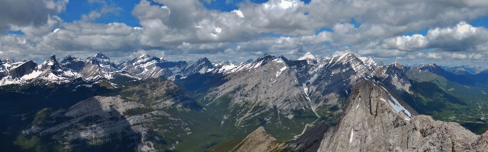
Looking back along the exposed ridge crest (right) to the stunning Kananaskis panorama beyond. From left to right: Mount Chester, the Fortress, Gusty Peak, Mount Galatea, Aiguille du Cuillière (Spoon Needle, foreground), Mount Eon (distant), the Tower, Old Goat Mountain (distant), Mount Engadine, Limestone Mountain (foreground), Mount Kidd (south summit), Mount Bogart, Mount Kidd (north summit), Wind Mountain (distant), Mount Allan and Mount Collembola. Click to see larger.
.jpg)
The Fortress.
.jpg)
The highest point in the Kananaskis Range: Mount Galatea (left) with Mount Eon in the distance beyond (right).
.jpg)
Mount Bogart’s snowy summit pyramid.
.jpg)
The Kananaskis River winds its way down the valley towards lesser peaks and the prairies to the north.
.jpg)
Grassy McKay Mountain and the front ranges to the east. Click to see larger.
.jpg)
A sea of peaks highlighted by the Fisher (left) and Opal Ranges (center). Click to see larger.
.jpg)
The snowy north face of Fisher Peak.
.jpg)
Mount Cornwall (left) and Outlaw Peak (right) over the Elbow Valley.
.jpg)
Mount Rae near Highwood Pass.
.jpg)
The continental divide visible in the distance beyond Opal Ridge.
.jpg)
The peaks of the continental divide (highlighted by Mount Joffre – center) make for an inspiring panorama. A variety of scrambles dot the foreground – from left to right: Grizzly Peak, Opal Ridge (south summit), Opal Ridge (north summit) and Mount Lawson. Click to see larger.
.jpg)
Glaciated Mount Joffre: the highest Canadian Rockies peak south of Mount Assiniboine.
.jpg)
Mount Inflexible.
.jpg)
Mount James Walker.
.jpg)
The register provides evidence of a busy day on the Wedge!
.jpg)
Summit photo with the Kananaskis Range before braving the ridge crest again on descent.
.jpg)
Marko and Charles make their way back along the ridge towards the crux (just above the second snow patch).
.jpg)
Marko and Amelie negotiate steep terrain at the crux. While the return trip up the crux is still intimidating, it is easier climbing up it on return.
.jpg)
Josée and Charles take on the most exposed bit as Marko and Amelie stroll along the suddenly broad ridge above.
.jpg)
A look back at the crux after successfully crossing it (again). Bear in mind that photos never provide a real sense of the actual degree of exposure!
.jpg)
Descending moderate terrain – the idiot who forgets his helmet gets to wait for everyone else to go down ahead of him.
.jpg)
Josée finishes off her day with a smile and a glissade (the two go hand in hand).
.jpg)
Watch out! They steal poles!
.jpg)
Marko enjoys the last of the alpine views before returning below the tree line. All in all, a wonderful outing with great company. It was so nice to finally meet Marko, Amelie and the Golden Scramblers!
.jpg)
.jpg)
.jpg)
.jpg)
.jpg)
.jpg)