Galwey Brook (Horseshoe Basin)
Elevation: 1560 m
Elevation Gain: 400 m (cumulative)
Galwey Brook is the official name of the watercourse which drains the eastern basin between Bellevue Hill, Mount Galwey and Lakeview Ridge and can be accessed via the Horseshoe Basin trail in Waterton Lakes National Park. The peak and the brook at its base were both named for Lt. R.E. Galwey who served as Assistant Astronomer on the International Boundary Survey between 1872 and 1876.
My Ascents:
June 18 2022
Trailhead: Horseshoe Basin Trailhead
GPS Track: Galwey Brook (Horseshoe Basin)
With a campsite booked in beautiful Waterton Lakes National Park, we cringed at a weather forecast that called for a cloudy and rainy weekend. 🌧️😒 When Saturday dawned 🌞 clear and sunny, however, we found ourselves “scrambling” to get out for a hike before the promised precipitation arrived. Having enjoyed a wintry visit ❄️ to Horseshoe Basin during my approach to Rogan Peak in 2019, I was interested to see it again in its full summer splendor. Waterton’s wildflowers are renowned after all! 🌼 I was also interested in potentially hiking all the way up nearby Lakeview Ridge but didn’t have any reasonable expectation of completing this ambitious (700 vertical meter) idea with today’s hiking party (which included, in no particular order, an arthritic dog, 2 small children, a 6-month pregnant wife 🤰 and my senior citizen parents).
.jpg)
Deciding to get to where we got to, we (somehow) all piled into our Toyota Highlander and drove the short distance to the hike’s trailhead just east of Waterton’s Bison Paddock.
.jpg)
.jpg)
LEFT: 6-year-old Mera and 4-year-old Penny managed to turn the trailhead infrastructure into a jungle gym while the rest of us laced our hiking boots. 😂
RIGHT: As we hiked east away from the Paddock, we were greeted by the first of the day’s many wildflowers!
.jpg)
Mera and Penny set the pace (and Grandma tries to keep up) en route to Horseshoe Basin. Bellevue Hill is prominent at left and the trail ascends the hill at its foot in the center of this photo.
.jpg)
.jpg)
LEFT: A sticky purple geranium: Geranium viscosissimum.
RIGHT: A three-spot mariposa lily: Calochortus apiculatus.
.jpg)
.jpg)
LEFT: Mera and Penny investigate the, somewhat, overgrown trail’s vegetation.
RIGHT: Like many young ladies today, Penny has taken to hiking with panache.
.jpg)
Grandma follows her girls as the trail steepens at Bellevue Hill’s foot.
.jpg)
.jpg)
LEFT and RIGHT: Thanks to a decent elevation gain and 2017’s catastrophic Kenow Fire, the hike now sports scenic, open views south towards Waterton.
.jpg)
.jpg)
LEFT and RIGHT: Paintbrushes (Castilleja miniate) are a favourite of mine for photography and a favourite of Mera’s for foraging (yum, yum).
.jpg)
Near the top of the hill, the Waterton Lakes just came into view beyond some goldenasters (Heterotheca villosa) that were, sadly, past their prime.
.jpg)
The Grayhairs (left) and the Preggers (right) crest the hill that ended up being the day’s high point.
.jpg)
Once over the hill, the trail continued down into scenic Horseshoe Basin. 😍
.jpg)
.jpg)
LEFT and RIGHT: Silky scorpion weed (Phacelia sericea) adds a splash of violet to the verdant valley. The last time that I was here, things were much more monochromatic!
.jpg)
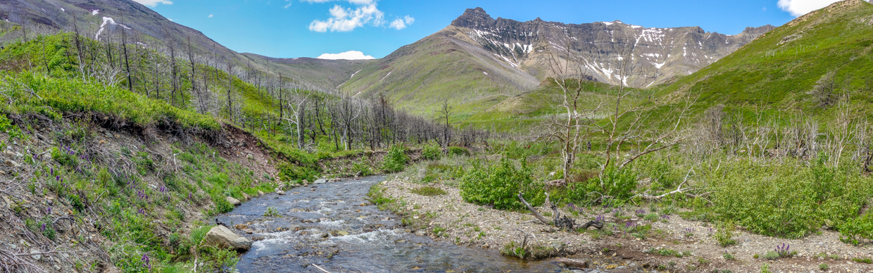
About 3.5 km from the trailhead, we finally found the brook beneath Mount Galwey (left), Rogan Peak (center) and Lakeview Ridge (right). Click to see larger.
.jpg)
.jpg)
LEFT: A closer look at Mount Galwey and its interesting/intimidating-looking summit block.
RIGHT: Rogan Peak (sometimes referred to as Dunwey Peak or The Horn) rises impressively above Galwey Brook.
.jpg)
.jpg)
LEFT: After a pleasant 4 km, the trail disappeared into the vigorous brook. Scouting upstream and downstream, we concluded that a boots-off ford would be required to continue further.
RIGHT: Crux certainly didn’t mind the idea of crossing the icy stream! Everyone else, however, was less keen. Having enjoyed a beautiful sunny morning thus far, we therefore decided to find a brook-side spot for lunch and to call it a day.
.jpg)
While we enjoyed lunch, Mera surveyed the scenic basin (and tempted fate by hopping across precarious/slippery rocks).
.jpg)
Mount Galwey and its namesake Brook.
.jpg)
.jpg)
LEFT and RIGHT: Happy hikers! Sometimes it’s best not to press on just for a summit. “Approach hikes” can be enjoyable too! 🙃 Like I said in the preamble above, we decided to simply get to where we got to!
.jpg)
After donating much of our lunch to Grandma and Grandpa (turns out there was a reason their packs were so light 😉), we started our return hike, stopping, from time to time, to appreciate the lovely panorama that we were leaving behind. Click to see larger.
.jpg)
.jpg)
LEFT: Mera, Penny (and yours truly) enjoy some pets from a much larger hiker we ran into on our way back up and out of the valley. 🐴
RIGHT: After chatting with the riders (and meeting a famous horse who, apparently, starred in “Heartland”), we continued back while those on horseback continued into the valley.
.jpg)
Scenic lake-wards views from the hike’s high point – it was all downhill from here!
.jpg)
A closer look at Glacier National Park’s craggy peaks to the south of Waterton and the Canada/US border.
.jpg)
.jpg)
LEFT: View towards bison in the paddock below and Montana’s Chief Mountain on the horizon above.
RIGHT: As has become customary, Crux found a very muddy body of water to cool off in only minutes before we arrived back at the car… 🙄
.jpg)
A scenic/muddy end to an unexpectedly sunny and pleasant hike!
.jpg)
Mom-to-be (again) Brianne and a wet, muddy dog (Crux) share the trunk on our drive back to the campsite. I wasn’t kidding when I expressed amazement 🤯 that we were all able to fit into a single vehicle! Like the hike, the packed car got us back to where it got us to and sticking my pregnant wife in the trunk simply got me in trouble! 🤣🤷♂️
.jpg)
.jpg)