If at first you don’t succeed, try, try again.
In 2019, we attempted Hailstone Butte as a family hike for Father’s Day. Back then, the peak’s formidable off-trail slopes and summit rock band proved too much for our (then) 3-year-old and 1-year-old daughters (in addition to their grandparents)! It was not, as we discovered, a route for novice hikers.
Fast forward three years to 2022.
With another weekend around the corner, Brianne and I discussed potential hikes for our family and longtime friend/suffering enthusiast Aurore. While we’d failed on the Butte’s “Roper Route” years earlier, subsequent research convinced me that its “Elk Traverse” offered a better chance of success. Brianne was unconvinced and Hailstone Butte was shelved and re-filed under the “bad idea” category. In the end, we settled on nearby Windy Peak (which we’d also attempted in 2020 but failed to complete because of hurricane-force winds).
On Saturday morning, we set out for Windy Peak/Hailstone Butte’s shared trailhead with a car full of kids, coloring books, markers, Timbits® and one French girl (squished between our children’s bulky car seats). Arriving at the pass-top pullout parking, we were flabbergasted. The wind was atypically calm! Perhaps Windy Peak was the perfect hike for today?
Nope. Hard nope. After gearing up and getting underway, we made it about 100 m from the car before we encountered the day’s first, powerful gust. Undeterred, we continued up. A hundred meters further, isolated blasts turned into a steady gale. Brianne looked unimpressed. Mera complained. The wind nearly knocked me over. Abort! Once again, Windy Peak was a no-go as the thought of 12 km on open ridgetop in such conditions was unenticing. “Luckily,” Hailstone Butte was nearby and, after a quick discussion as to potential “Plan Bs”, it seemed less and less like a “bad idea” and more and more like a “can’t hurt to try” kind of hike… 😏
.jpg)
Looking towards Hailstone Butte from very low down on Windy Peak (which was as far as we made it in that direction). Hailstone’s most enticing attribute was that its various routes all ascend east-facing (lee) slopes which (we hoped 🙏) would be sheltered from the wind! The amount of lingering snow/cornice visible atop Hailstone was cause for some concern but, at this point, that was a “future us problem.”
.jpg)
.jpg)
LEFT: Mera enjoyed the lively creek which we followed up-valley.
RIGHT: Penny thrashes along on the bushy, valley-bottom trail. From the get-go, there’s a low route (which follows the creek) and a high route (which traverses slopes above the creek). Seeking shelter from the wind, we opted for the lower, wetter, bushier route but, with the benefit of hindsight, I’d take the higher path. 😂
.jpg)
Mera gamely follows the trail towards the grassy pass at right.
.jpg)
Stopping for a quick geology lesson with Aurore…
.jpg)
… and stopping to let the pretty, pregnant lady catch up! “C’mon Goat!” 😂 💕 (photo courtesy Aurore Kurc)
.jpg)
Enjoying a snack/cuddle stop at the grassy pass immediately below Hailstone’s steep summit. From here, the route splits. To the left, the more popular “Roper Route” ascends steep grass before breaking through a weakness in the rock band above. To the right, the “Elk Traverse” sidehills across steep dirt/shale/scree (unseen from here).
.jpg)
While we munched our lunches, we watched another party ascend the “Roper Route” above. The scrambling looked pretty easy but I think that the lingering cornice blocked the easiest and most direct route through the cliff.
.jpg)
With a cornice in their way, the other party traverses an exposed bench towards the summit. Nibbling away at our sandwiches, we decided that this scramble didn’t look appealing with two small children, an arthritic dog and a pregnant wife. And so, the decision was made to check out the “Elk Traverse!”
.jpg)
Crossing a small patch of snow to reach the actual “Elk Traverse.” (photo courtesy Aurore Kurc)
.jpg)
Aurore guides Mera across the “Elk Traverse’s” extremely narrow trail (while Brianne handles Crux and I guide Penny unseen). Sections of this traverse are steep enough to induce vertigo 😵💫 in those prone to it but the dirt/shale were very soft and provided excellent purchase. Note, however, that any snow on the dirt/shale could make this traverse very dangerous.
.jpg)
After completing the “Elk Traverse”, we looked up and saw more of the same (cliff and cornice)! Instead of tackling these directly (as some do), we chose the wisest (but longest) route for our group and aimed for the snowy fire road to the north. Getting there involved a slight loss of elevation and some side-hilling across meadows/boulders but these proved relatively easy.
.jpg)
Crux follows Brianne and Aurore up the snowy fire road. Ahead, the active fire lookout atop Hailstone Butte is obvious. What is also obvious is how far of a detour the fire road takes (about 2 km)! The skyline ridge to the lookout’s left shows the much shorter ascent that is possible from the end of the “Elk Traverse.” From here, it doesn’t look bad but, from below, it looked far too steep, scrambly and snowy for our merry band of little-legged hikers. If nothing else, the fire road helped Brianne and I get our steps for the day in! 😉
.jpg)
As we hiked up the long, snowy fire road, I became increasingly concerned that we’d still end up having to kick steps or chop through the cornice at some point. Thankfully, the cornice had been reduced to a meagre snow patch at the point where the road crested the ridgeline! 🙏
.jpg)
Normally, Hailstone’s broad summit plateau would make for fine hands-in-pocket walking, however, Mera and Penny were unusually intent on holding hands as we neared the lookout.
.jpg)
Crux, Penny, Brianne and I on final summit approach! (photo courtesy Aurore Kurc)
.jpg)
.jpg)
LEFT and RIGHT: Atop Hailstone Butte, we found the (still-unmanned) fire lookout which featured one of the nicest high altitude patios in the Canadian Rockies!
.jpg)
.jpg)
LEFT: Mera poses in the center of the lookout’s impressive patio!
RIGHT: Chocolate chip banana bread muffins (courtesy Aurore Kurc)! We may need to start inviting her on more family hikes… 🤔
.jpg)
Summit high fives all around! 🖐️🖐️
.jpg)
Brianne, Aurore and Penny enjoy the view from the lookout’s upper deck. Normally, we’d give a lookout a wide berth to respect the privacy of the person inside but, today, no one was home and we were grateful to shelter in the building’s lee; Remember that steady gale that chased us off Windy Peak earlier? It found us again atop Hailstone Butte!
.jpg)
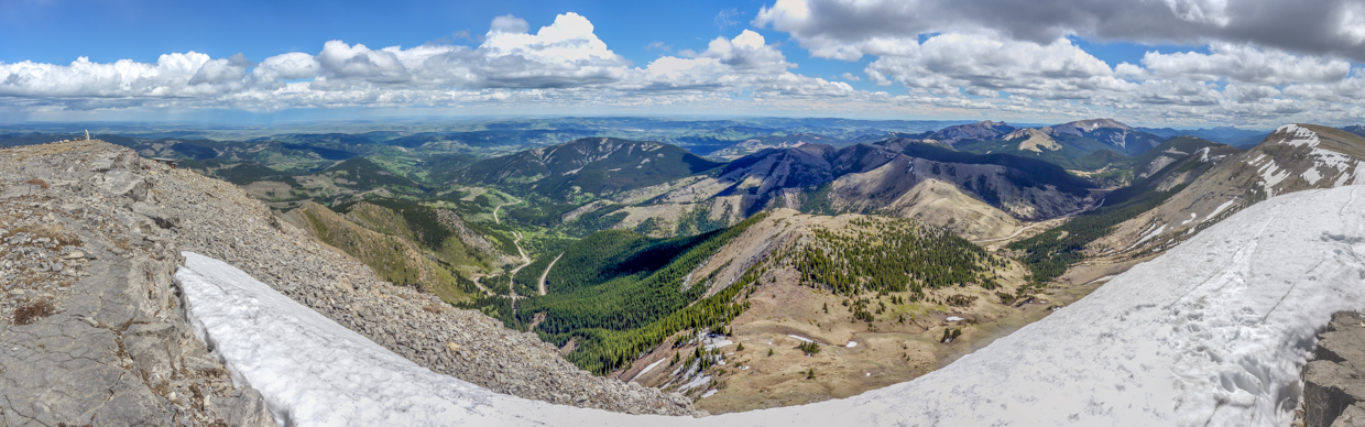
Braving the breeze to take in the fine foothill-filled panorama to the east. Click to see larger.
.jpg)
Enjoying the vibrant greens of late spring/early summer – of course, this was looking over the prairies to the east. Sadly, the mountains to the west still looked like winter…
.jpg)
The southeastern view is dominated by 4 quasi-mountains: Saddle Mountain (center), Windy Peak (center right), Mount Hornecker (behind Windy) and Mount Livingstone (center right).
.jpg)
Looking south over the peak’s pretty patio. 😍
.jpg)
Isola Peak (center) and Monad Peak (right).
.jpg)
To the west, the larger peaks of the High Rock Range (including Beehive Mountain – center right) appeared and disappeared amidst the swirling clouds.
.jpg)
The northward panorama stretched from Plateau Mountain (left) to the prairies (right). Click to see larger.
.jpg)
A closer look at Plateau Mountain’s eastern escarpment and remarkably flat top.
.jpg)
Looking north towards a trio of nearby peaks: Mount Burke (center left), Sentinel Mountain (center) and Iron Creek Mountain (right).
.jpg)
Stormy skies over Mount Burke. If you look closely, you can see the dilapidated remains of the old fire lookout on its summit. Remarkably, the building up there is still standing despite having been abandoned in favor of Hailstone Butte in 1952.
.jpg)
For more ambitious hikers (ie: those without small children), the traverse to Iron Creek Mountain (right) and Sentinel Mountain (center left) is possible as a day trip from Hailstone Butte.
.jpg)
With storms brewing in a few different directions, we decided not to push our luck too much and, after 30 minutes, we took a group photo on top and started our hike back down.
.jpg)
.jpg)
LEFT: Despite being tempted to shortcut down steeper slopes directly below the lookout, we decided that it would be best for our littles to descend the way we’d come up (via the much longer fire road). Black clouds to the north, however, had us questioning this decision a little! 🌧️
RIGHT: Mr. Crux enjoys a final sit in the sun (and snow) as the questionable weather approaches.
.jpg)
Making our way off the broad summit plateau in the nick of time (right as the incoming weather overtook us).
.jpg)
After following the fire road down, we made our way uphill over open (but now rainy) meadows towards the “Elk Traverse” (which was just on the other side of the col ahead).
.jpg)
Aurore teaches the girls to frolic at the col (“trolololololo!”).
.jpg)
Looking across the “Elk Traverse”. A warning: it doesn’t look like much from here but it definitely feels exposed when you’re on it! Our kids are pretty capable hikers already but we were certain to keep a very firm grip on their hands as we crossed!
.jpg)
Safely across the “Elk Traverse”, Aurore and Mera navigate a small snow patch before returning to terra firma.
.jpg)
This angle gives a better idea as to the "Elk Traverse's" trail (or lack thereof)! 😱 Fortunately, from here, the going was relatively easy peasy lemon squeezy. 🍋 (photo courtesy Aurore Kurc)
.jpg)
.jpg)
LEFT: Sometimes you just need to stop to smell the flowers. And if there are no flowers, stop to pick the grass! 😂
RIGHT: After collecting a bird’s nest-worth of grass, we did manage to get Penny moving again and, hand-in-hand, all the girls resumed their descent.
.jpg)
.jpg)
LEFT: Oh! There’s that aforementioned (pasque) flower! 🌷 Better stop to smell it (or at least photograph it)!
RIGHT: A photogenic dead tree marked the end of our descent and provided a nice view back towards our unplanned summit.
If at first, you don’t succeed (and if the wind on Windy Peak is really, really, really awful), try, try Hailstone Butte again! 😂
.jpg)
.jpg)