Simpson River
Elevation: 1260 m
Elevation Gain: 50 m
The North Simpson River flows west from the continental divide at Simpson Pass before joining the Simpson River. Both are tributaries of Kootenay National Park’s Vermilion River. The Rivers, Pass and a Ridge nearby were all named for George Simpson. Simpson was the Governor of the Hudson’s Bay Company when he became the first European to cross his namesake pass (with a party of 22 men and 45 horses) in 1841. Simpson’s journey was part of a trip around the world which also furthered his company’s expanding fur empire. Simpson left London in March 1841, successfully crossed the Atlantic, Canada, the Pacific, Asia, Russia and Europe, returning to London in October 1842. In doing so, George Simpson became the first recorded person to have circumnavigated the world by land.
My Ascents:
July 25 2022
Trailhead: Simpson River Trailhead
GPS Track: Simpson River Interpretive Trail
As part of a recent Kootenay National Park camping trip 🏕️, I’d identified the Simpson River Trail as a prime candidate for a family hike. On paper, the trail appeared to have it all: new interpretive signs to amuse the kids, wide open mountain views for me (thanks to an abundance of recent wildfires – most recently in 2017), a relatively gentle elevation profile for my increasingly pregnant wife 🤰 and the option of extending our hike all the way to Magog Lake (30+ km each way 😏) if we so desired. Simply put, I figured that the Simpson River Trail would be a great family hike and I’m happy to report that it was! In my opinion, this hike is a blatant omission from many Rockies hiking guidebooks and it’s a pity that most who blast down Highway 93 South are oblivious to its existence!
.jpg)
From the marked Simpson River Trailhead on Highway 93 South, an impressive bridge spans the Vermilion River, providing phenomenal views towards Hawk Ridge and easy access to the Simpson River Trail.
.jpg)
.jpg)
LEFT: Following the area’s most recent wildfire in 2017, signs like this have popped up all over Kootenay National Park. I suppose this is cheaper than actually clearing trails and ensuring that they are safe? 🙄 My favourite line from the sign has to be: “Spread your group out to reduce the risk of multiple casualties.” Curiously, this is the opposite of the “travel in tight groups” advice that is considered safest for hikes in bear territory… As a simple suggestion to Parks Canada, consider sending trail crews into Kootenay NP rather than just lining the pockets of sign-makers? (But that’s none of my business…🐸☕)
RIGHT: Another windfall for the sign-maker’s kids’ college fund 🙃. At least these interpretive signs were cute and engaging. This one encouraged youngsters to find soot (from trees that probably fell on other hikers 🤣) to create artwork on the white panel below.
.jpg)
.jpg)
LEFT and RIGHT: 6-year-old Mera and 4-year-old Penny pose behind interpretive panels that highlight some local wildlife. Who knew we had a hawk and a jumping mouse in the family? 😝
.jpg)
.jpg)
LEFT: Penny enjoys the “balance beam” over a small creek.
RIGHT: Wildflower-filled views towards Mount Shanks. Now that looks like a "fun" mountain to climb, doesn’t it?... 💡
.jpg)
After about 1 km, we reached the trail’s only actual hill (near the confluence of the Simpson and Vermilion Rivers) and easily clamored up it.
.jpg)
The hill’s slight elevation gain provided a wonderful view of the Simpson River as it wound its way west towards nearby Hector Gorge. 😍
.jpg)
.jpg)
LEFT: Mount Shanks poses proudly beyond a half dozen homicidal psycho killer trees.
RIGHT: An interpretive sign highlights the region’s extensive recent wildfire history. Sadly, climate change makes it likely that catastrophic events like these will continue to take place with ever increasing frequency. 😟
.jpg)
1.5 km from the trailhead, we reached the interpretive trail’s terminus at a set of Red Chairs that were conveniently placed below unstable trees. 🤔 The kids chairs were a cute touch that I’ve not previously seen though. 😊
.jpg)
.jpg)
LEFT: Mera takes in the wonderful views of Kootenay NP while lunching in her mini red chair. #InstagramPoser
RIGHT: Penny and Brianne obviously enjoyed the chairs as well.
.jpg)
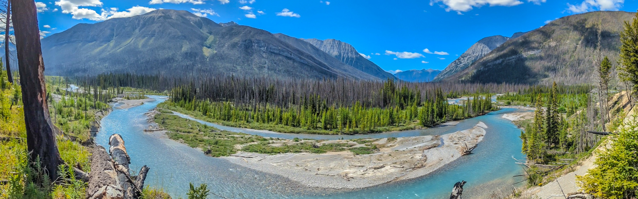
A nearby embankment provided a wonderful panorama towards Spar Mountain (center left), Mount Wardle (center right) and the serpentine Simpson River at their base. Click to see larger.
.jpg)
Indian Peak (center left) and Octopus Mountain (Center right) highlight the view up the fireweed-filled valley from the red chairs.
.jpg)
While the red chairs marked the end of the interpretive trail, the hike had proven so beautiful that we elected to extend it by continuing up-valley after lunch on a series of (currently) unnecessary bridges.
.jpg)
.jpg)
LEFT: Soot-covered 4-year-old in 3, 2, 1…
RIGHT: Enjoying a plethora of photographic possibilities on a hot, sunny, summer afternoon. 📷🤩
.jpg)
After hiking about a km beyond the red chairs, we found a spot with a nice view towards Mount Wardle (left) and the Simpson River and decided to call it a day. So much for my hopes of a 30+ km family epic into Assiniboine Provincial Park. 🙃
.jpg)
.jpg)
LEFT and RIGHT: Beautiful girls in a beautiful valley! 😍
.jpg)
A charred remnant of roots provides an indication of how much soil got nuked during 2017’s Verdant wildfire.
.jpg)
Mera and Penny hike back towards the red chairs (which literally sit below that group of homicidal psycho killer trees instead of 100 m further in an open meadow). Speaking of meadow, this one was a special place; one filled with wildflowers and pollinators. Indeed, the whole field was alive with the buzzing of fuzzy bees as the abundant fireweed swayed in the gentle afternoon breeze. This is definitely a spot worth hiking 1.5 km along flat ground to reach!
.jpg)
.jpg)
LEFT: The kiddos hike down the day’s only hill amidst the day’s best view!
RIGHT: The hike proved so pretty that even Preggers had a smile on her face (despite temperatures which exceeded 30 degrees C 🥵)!
.jpg)
THIS is what I’m talking about! Kootenay NP at its absolute finest!
.jpg)
Mera and Brianne take on the final flat walk back to the bridge.
.jpg)
.jpg)
LEFT: Since no one takes any pictures of me, Penny agreed to pose for a selfie by the Vermilion River. Look at how coordinated we are!
RIGHT: Penny flashes a victory sign ✌️ on the bridge after avoiding death by falling tree 🙃 on the Simpson River Trail.
.jpg)
A perfect end to a perfect family hike: special drinks on the banks of the glacier-fed Vermilion River! The Simpson River Trail truly is a gem 💎. One of Kootenay’s most underrated and easiest trails in my opinion! In fact, the area is SO nice, I might have to come back again someday… Someday soon perhaps…
.jpg)