Adventure (noun):
1) An exciting or remarkable experience.
2) An undertaking usually involving danger and unknown.
The above definitions highlight both the allure and the cost of adventure. To be truly exciting and remarkable, the outcome of an adventure cannot be a sure thing. There must be an element of risk – an element of unknown.
After a 5-month hiatus, I was ready for another mountain adventure. Seeking to make up for lost time, I decided that it should be a grand one, an exploratory adventure in the pristine backcountry. This adventure would not be taken from the pages of a guidebook. It would not follow in the footsteps of others (although a broken trail would have, in retrospect, been nice). Success could not be assured or even reliably guessed at. I wanted more than the satisfaction of a summit. I wanted the satisfaction that comes with planning a route start-to-finish and then seeing if it goes.
Of course, coming home safe is always my #1 priority. So, the trick to this adventure would be finding a mountain that offered up more unknown than danger. To that end, I looked for a big peak in the main ranges that had at least one low-angled aspect. Consulting topo maps, Hawk Ridge’s most northerly peak intrigued me. If the contour lines were to be trusted, the peak’s west ridge looked relatively benign from an avalanche perspective (less than 27 degrees). Said slopes were, however, not a sure thing. Brush, snow depth, isolated terrain features and cliff bands smaller than a topographic contour could not be foreseen; I could find no beta on the peak’s west ridge online or in books (which was perfect)! Without knowing if the route would go, I recruited my go-to partner for such undertakings: Matt Clay (who in turn recruited his wife Sandra and his friend Rob). Leaving Calgary, in the morning’s early hours, we drove deep into the heart of Kootenay National Park for an overdue exploratory adventure.
.jpg)
From a bitterly cold Floe Lake parking lot (-25 C), we set off to answer that age-old question: Why did the snowshoers cross the road? The answer? To get to the other side, ascend Hawk Ridge North (center right) and suffer immeasurably along the way. 😂
.jpg)
.jpg)
LEFT: On ascent, we elected to follow the Ball Pass trail since it had been recently broken by a skier. With so much unknown terrain ahead of us, we figured that we’d take advantage of easy travel for as long as it was possible to do so! Ahead, our objective and our proposed ascent route up its west ridge (left-hand skyline) were both visible.
RIGHT: Knowing that we’d eventually need to cross nearby Hawk Creek, we grew weary when the Ball Pass trail climbed higher on the creek’s opposite bank (about 1 km from the road). Back-tracking slightly, we found a slope that was open (only because it was littered with buried deadfall 🤨) and descended to the creek bed below.
.jpg)
.jpg)
LEFT: Sandra thinks “light thoughts” (such as "don't fall in") while crossing frozen Hawk Creek.
RIGHT: Matt C. leads the charge up the deadfall-littered creek. During the summer, this creek bed would be a nightmarish labyrinth of logs but, buried under deep snow, they presented little challenge for the time being. What did present a challenge, however, was attempting to find a suitable place to begin our ascent on the creek’s south (right) bank (which was either densely treed with saplings or impassable thanks to incompletely buried deadfall).
.jpg)
About half a km from where we started up the creek, we found the first clearing on its south bank that looked even remotely tempting to start up. Unfortunately, the clearing was not especially large and Matt C. seemed extremely concerned about the, seemingly, "impassable" green wall of saplings on its margins…
.jpg)
As the wall of green saplings closed in on us, we were soon left with no option but to plow straight through the thicket. This entire area was scorched by wildfire nearly 20 years ago and we, naively, thought this would mean open terrain below tree line. Nothing could have been farther from the truth. Apparently, 20 years is enough time for a horrifically thick sea of saplings to sprout up. The acrobatics that followed would have been amusing to behold had we been able to levitate 20 feet above the mess. Weaving through the thicket, our snowshoes snagged with every step. Branches whipped our faces 🤕. Surprisingly sturdy saplings failed to bend as anticipated, knocking us off our feet. Hidden holes appeared suddenly underneath, sometimes swallowing us whole. To make matters worse, the previously blue sky disappeared as malevolent clouds moved in. Some spoke openly of quitting while others laughed off this suggestion, pretending, for the time, that it must have been a joke. In short, the “suck” level was high; perhaps off-the-charts. It took us about 90 minutes to cover 1 km of accursed ground in this manner…
.jpg)
Mercifully, even the nastiest of thickets are finite. As we SLOWLY gained elevation, the mess eventually thinned (thank God for shorter growing seasons at altitude). Through sheer will, we persevered and entered a new circle of hell; one in which impassable brush was now replaced with 700 vertical meters of steep trail-breaking. At least the sky had begun to clear? 🤷♂️
.jpg)
.jpg)
LEFT: Typical terrain in Hawk Ridge North’s second circle of hell. While the west ridge was, generally, low angled, there were a great many rolls and terrain features that were very, very steep. Matt C. measured one such slope at nearly 50 degrees! Obviously, we took great care and plotted the safest possible course up these slopes. The avalanche risk below tree line was “low” on this day but this is not a route I’d want to attempt in less stable conditions.
RIGHT: Rob “enjoys” a well-earned respite at the back of the pack after a long shift breaking trail at the front 🥵. I am, utterly, convinced that our attempt would have failed if we’d had fewer trail-breakers. Whether it was in the sapling sea or the steep snow above, the ascent was positively gruelling. With 4 people to alternate leads, at least, it proved manageable.
.jpg)
Thinning, burnt forest yielded spectacular views as we continued, slowly, up, up, up. These views provided much-needed inspiration as we dug deep despite being exhausted…
.jpg)
…Of course, the view ahead was not nearly as inspirational. Trending to the left to gain the gentler skyline ridge, the vertical gains and efforts required to break trail through 1 foot of fresh powder continued to pile up.
.jpg)
.jpg)
LEFT: As the views continued to improve, Matt C. broached a rather depressing topic: turnaround time 🕑. It was a sensible thing to discuss as the ground we’d won to-date had come at a high temporal cost. Nevertheless, it was hard to imagine returning to the dreaded thicket below without an ounce of summit satisfaction. In the end, 2 pm was determined to be reasonable. No one was keen to stumble, thrash and fall through the sapling sea in the dark.
RIGHT: As we finally crested the upper west ridge, our summit (at last!) came into view. At this point, the peak was, however, still 400 - 500 m above us so it’s hard to tell if its sudden appearance was motivating or demotivating…
.jpg)
Rob and Sandra tackle the trail-breaking duties on the, increasingly, wind-affected upper west ridge.
.jpg)
Matt C. pauses for a much-needed breather and poses alongside nearby Isabelle Peak.
.jpg)
As we left the last of the burnt trees behind, the views towards the Vermilion Range full-on EXPLODED 🤯.
.jpg)
At last, the summit began to look attainable as our turnaround time drew perilously close. Seeing the summit up close, however, we realized that we wouldn’t be the day’s first summiteers…
.jpg)
GOATS!!! SUMMIT GOATS!!! BAH GAWD – SUMMIT MF’ING GOATS!!! Before spotting these white, wholly wonders, I’d been dead-to-the-world, barely managing to put one foot in front of the other. Inspired by their gloriousness, however, I found my second wind and charged to the front of the pack. It was 1:55 pm and there would be no turning around anymore.
.jpg)
Atop the ridge crest, Matt C. surveys the spectacular view south along Hawk’s long spine towards the “Matterhorn of the Rockies.”
.jpg)
A small-looking Rob makes his way up amidst massive terrain.
.jpg)
Wind-carved waves and a lonely little larch pave the way towards Hawk North’s summit. The rock bands above were easily bypassed to the right.
.jpg)
With the summit at-hand, Rob went for it. While the summit block looks unintimidating in this photo, it was not trivial! As we closed in, its steepness became apparent. Rob scrambled up rocks on the left of this photo while I attempted to cut the ascent angle by gaining the right-hand ridge. Just below the summit, however, a sizeable cornice turned me back. Retreating and removing my cumbersome snowshoes, I tried again (this time bootpacking up Rob’s line). Exhausted, I labored upwards, simultaneously aware of, but ignoring, my now-cramping quadriceps 🥵.
.jpg)
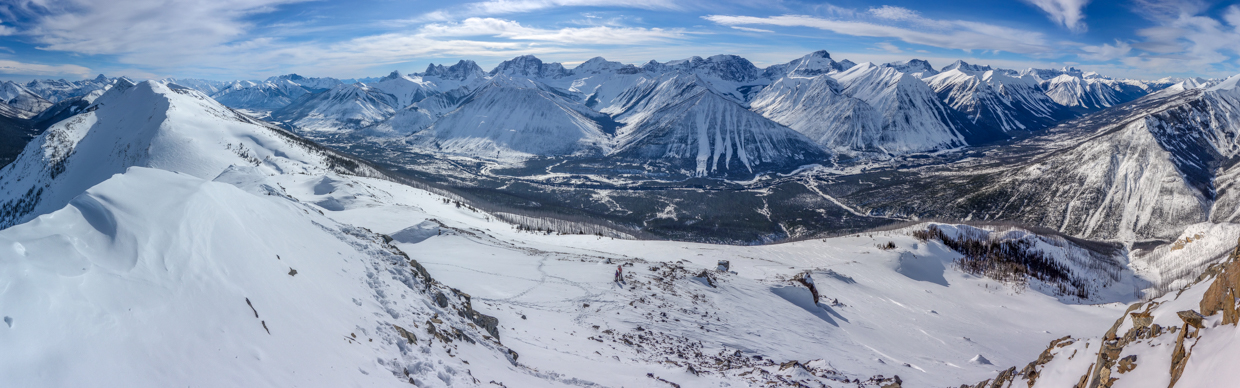
After 6 hours of suffering (moving at an average pace of 0.85 km/hour), the adventurous were rewarded mightily. Click to see the spectacular Vermilion Range in more breathtaking resolution.
.jpg)
Highway 93 South winds its way along the base of Hawk Ridge’s long spine. Mount Shanks (left) can be seen rising up beyond the rest of Hawk Ridge while a host of other Kootenay giants (including from left to right: Octopus Mountain, Mount Sam, Mount Docking, Lachine Mountain, Mount Harkin, Mount Selkirk, Spar Mountain and Split Peak) tower beyond.
.jpg)
To the north of Split Peak (left), the 46-km-long Vermilion Range begins its journey northward. Peaks visible from left-to-right include: Mount Wardle (center left), Mount White Tail (center right), Mount Verendyre (right) and Serac Ridge (foreground).
.jpg)
To the west, Floe Peak, Foster Peak and Mount Hewit make for an imposing backdrop to Numa Mountain (center right).
.jpg)
A closer look at Floe Peak. Famous Floe Lake resides, frozen, in the alpine basin on the far right.
.jpg)
At 3,201 m elevation, Foster Peak is the highest peak in the Vermilion Range. Numa Mountain (right) is comparatively minute despite the fact that its ascent involves an elevation gain of 1,500 vertical meters.
.jpg)
.jpg)
LEFT and RIGHT: Adventurer Matt and adventurer Rob atop Hawk Ridge North.*
*Adventurers not shown to scale.
.jpg)
Looking up-valley towards the Vermilion Range’s northern extent. From left-to-right: Hewit Peak, Tumbling Peak, Mount Gray and the aptly-named Rockwall. Beyond the Rockwall, the Goodsirs punctuate the horizon with their lofty, crumbling towers.
.jpg)
A closer look at the Rockwall and the towering Goodsirs.
.jpg)
The eastward summit panorama was somewhat obscured by a large cornice but this view towards nearby Banff National Park was pleasant, nonetheless. Click to see larger.
.jpg)
Immediately north, the trio of more proximate peaks is (from left-to-right): Vermilion Peak, Mount Haffner and “Haffner Senior.” In the distance, Mount Owen and Mount Misko are visible to the left of Vermilion Peak. Behind Vermilion, Mount Oke pokes upwards while Ochre Spring Peak can be seen to its right. Between Haffner and “Haffner Senior,” Lake O'Hara's Mount Odaray and Mount Biddle are recognizable while Lake Louise's Mount Victoria makes a cameo on the far right.
.jpg)
Nearby Isabelle Peak is big but it’s not quite big enough to completely obstruct the view of behemoth Mount Ball behind it.
.jpg)
Crazy goat prints follow the cornice east towards Ball Pass.
.jpg)
Ball Pass provides a small window into nearby Banff National Park. In Banff, Block Mountain (center left), Flint Peak (center) and Noetic Peak punctuate the horizon beyond Gibbon Pass Peak (left) and Copper Mountain (right).
.jpg)
Sandwiched between the Ball Range (left) and the Vermilion Range (right) and just north of massive Mount Assiniboine, Hawk Ridge is surrounded by the some of the best views that Kootenay National Park has to offer (just as I hoped it would be 😊). Click to see larger.
.jpg)
Haiduk Peak and Scarab Peak (center) stand between Kootenay and Banff’s Egypt Lakes. To the left, a pair of reasonably large peaks are, surprisingly, unnamed. To the far right, the impressive Monarch commands the skyline.
.jpg)
To the south, Mount Assiniboine rises up beyond the Monarch, Simpson Ridge and Nestor Peak.
.jpg)
The requisite telephoto shot of the highest peak in the Southern Canadian Rockies: Mount Assiniboine.
.jpg)
Another requisite shot: the summit selfie (because tripods are for suckers 🙃).
.jpg)
.jpg)
LEFT: Thanks to a biting wind 🥶, a lapsed turnaround time and climbing partners who were already in retreat, our summit stay was brief (only 8 minutes!). It may be just as well, however, as I was too exhausted to fully enjoy the experience. Fortunately, I get to relive it under more comfortable conditions as I sort through my photos 🤩 and write up my trip report at home.
RIGHT: Foster Peak framed by a fire-twisted tree.
.jpg)
Still-impressive views towards Isabelle Peak as we retrace our track down Hawk’s upper west ridge. Despite the remarkable views and our now-gravity-assisted travel, this part of the day was almost as unpleasant as the sapling and steep circles of hell that preceded it. You see, by this point, my reserves were spent. I was dead on my feet, stumbling downhill feeling, literally, nauseous as a result of the day’s exertion 🤢. And we still had 1,000 vertical meters to descend…
.jpg)
.jpg)
LEFT: Plunge-stepping my way back to the group. As we descended the wind abated, allowing for a LONG overdue lunch break at 3 pm. I felt ill but I forced myself to eat. Eventually, I started to feel human again and no longer worried that I’d wretch all over the west ridge (all thanks to the miracle of blood sugar)!
RIGHT: With our reserves somewhat restored, we continued downward. No one was looking forward to the horrific thicket at the west ridge’s base (which appeared suddenly in the form of a carpet of green on the burnt forest floor). Delirious, I paused just above it and burst into an uncontrollable laughter. The arch-villain maniacal sort. I don’t even know why but I couldn’t stop. So, I stepped into the sapling sea to literally wipe the smile off my face with a thousand pine branch lashes.
.jpg)
Fun times as Rob crashes into a hidden pit created by the unholy combination of buried deadfall amidst the accursed saplings. It turns out that extricating oneself from such a predicament is made all the more challenging while wearing snowshoes… Objectively, this may have been the most dangerous part of our day as the likelihood of a badly twisted ankle etc. was significant thanks to much hidden deadfall. Despite re-tracing our track with the utmost caution, scenes like this were an inevitability for us all.
.jpg)
Sandra supervises while Rob struggles to de-pit himself. Don’t worry – he succeeded (eventually 😂).
.jpg)
.jpg)
LEFT: Glory be! After an extremely cautious descent, the thicket eventually gave way to Hawk Creek’s more open and scenic terrain.
RIGHT: Rob enjoys the creek’s more mindless travel as the day’s last rays light up Isabelle Peak behind us.
.jpg)
The group of intrepid adventurers make their way down Hawk Creek’s pillowy snowscape as the sun, literally, sets on this particular suffer-fest. On descent, we elected to follow Hawk Creek all the way back to the road (even though this would mean about 1 km of trail-breaking). The broken Ball Pass trail was nearby but none of us had the energy or will to gain the 20 vertical meters that would be required to get back on it!
.jpg)
On the Road Again… Our adventure concluded with a half km stroll back to the parking area along the busy highway. Passing motorists no doubt wondered who these forlorn and exhausted-looking bushmen (and bush-woman) were and what undertaking had reduced them to their current, sad states. 🥴
Spent and exhausted, I cracked a cold beer 🍺 back at the parking lot. Hawk Ridge North was every bit the adventure that I hoped it would be.
.jpg)
.jpg)
.jpg)