Fortune favors the bold (but boldness can get you killed in the mountains). In planning my first scramble of the season, this was the dilemma that I faced.
An unusually hot May erased memories of our bitterly cold winter almost as fast as it melted the Rocky Mountain snowpack. Peaks on the eastern slopes rapidly rounded into form and internet hiking blogs and forums were abuzz. With multiple ascents reported, it seemed that any number of front range peaks would make fine objectives and my head told me to take the sure bet.
At the same time, my heart was pulling me towards the more spectacular main ranges. Their higher elevations and deeper snowpack typically means that these peaks retain their ‘winter coats’ well into the summer. This is great for mountaineers but creates a problem for less technically-savvy scramblers like myself. Given the recent heat, however, I had a feeling that south-facing aspects in the heart of the Rockies might be opening up. These routes present a significant risk-reward conundrum. The reward is mind-blowing scenery and the potential for an “easy” ascent and descent on stable, summer snow. The risk, however, is that solar heating on steep, south-facing snow slopes creates the obvious potential for avalanches. Without any recent beta on snow levels or conditions, there was really no way to know how things were shaping up in the main ranges without driving out to see! From there, careful evaluation of current conditions would be required to determine if an ascent was reasonable or if the drive west was simply a waste of gas.
Having reached out to Matt Clay and discussed these concerns, we both decided to be uncharacteristically bold and fortune favored us with a spectacular early season ascent in the heart of Kootenay National Park.
.jpg)
Looking south along the Vermilion River from the deck of an absurd bridge which is reached only moments from the “Paint Pots” trailhead.
.jpg)
Early morning ochre reflections. Who knew that mud could be so scenic?!
.jpg)
Matt C. stops to take in the view of the “Paint Pots” where springs lead to the formation of natural iron oxide dams, behind which colorful water pools.
.jpg)
Having just spent more time photographing mud than we ought to have, Matt C. and I hoped to make up time as we continued up the forested trail beyond the “Paint Pots.” Unfortunately, our progress was slowed by numerous amphibious encounters. In the cool morning shade, we nearly stepped on 3 or 4 of these still-lethargic toads!
.jpg)
After 3.4 km of easy travel, we reached the first obvious avalanche crossing where it appears to have been a bad winter for some established trees on the slope’s periphery!
.jpg)
Looking up the open avalanche slope at the route ahead (mouse over to see). Although the summit looks close from here, it is still 4.5 km away and a discouraging 1,280 m above! Despite the elevation gain to come, we were, nevertheless, elated to see less snow than we’d expected. Indeed, the presence of dry scree/rock ribs on the upper mountain suggested that we’d likely be able to stay on dry terrain if conditions did not allow for the safe ascent of snowier slopes.
.jpg)
A moose antler stands out among the slope’s litany of avalanche debris. Matt C. and I each picked up the antler to examine it more closely and couldn’t believe how heavy it was! No wonder moose shed these burdensome adornments annually!
.jpg)
Matt C. starts up consolidated avalanche debris (note the large terminal pile from an earlier slide just ahead of him!). On the mountain’s lower slopes, this debris was set like cement, providing a frozen highway up.
.jpg)
Glacier lilies color the mountainside yellow. These plants waste little time, flowering almost as soon as they aren’t snow-covered.
.jpg)
White pasqueflowers are also among the first to bloom once winter snow retreats in the Rockies. As the season progresses, this flower’s seed pods will take on a muppet-like appearance that hikers will easily recognize.
.jpg)
Beautiful scenery unfolds behind us as we kick-step our way up.
.jpg)
“Where it all begins.” A spring high on the mountain briefly undercuts our avi debris highway.
.jpg)
About halfway up the mountain, the main avalanche gully split. At the fork, Matt C. and I continued up to the climber’s left where the terrain was less steep. It was around this point, that the peak’s snow transitioned. On the lower mountain, consolidated avi debris made for safe, easy travel. On the upper mountain, however, the snow was a mess of waist-deep slush. In addition to being a post-holing nightmare, this unconsolidated snow presented a risk that we deemed unacceptable. Having not yet stabilized, there was no guarantee that this snow wouldn’t slide! After post-holing a couple times, we made the quick decision to stick to dry terrain from this point forward. Luckily, the peak was sufficiently thawed to allow for this possibility!
.jpg)
Matt C. follows a steep, but dry, rock rib (mouse over to see our route). With snow-filled gullies on either side, this terrain feature wasn’t exposed to any overhead avalanche hazard but, once on it, it was essentially “summit or bust” for us since we had no desire to cross the steep, slushy slopes which bookended it.
.jpg)
Fortunately, the rock rib remained dry and never got technical. Unfortunately, it was TFS and the loose dinner plate scree on it was among the worst that I’ve ascended.
.jpg)
Every bit as fun as it looks…at least the scenery is improving (photo courtesy Matt C.)!
.jpg)
Interesting geology – I’m not sure how rock strata end up at right angles like this.
.jpg)
After a seemingly interminable grind up steep, loose scree, we finally reached the ridge crest and were relieved to see the summit within striking distance to the northwest! Obviously, we stayed well to the climber’s left of the potential cornice here.
.jpg)
Spectacular wallowing! As the slope angle abated, we were treated to a final few steps of belly button-deep post-holing before reaching the spectacular summit. Both Matt C. and I carried snowshoes up the entire mountain to deal with this exact contingency but were too tired to bother putting them on when it arose (photo courtesy Matt C.)!
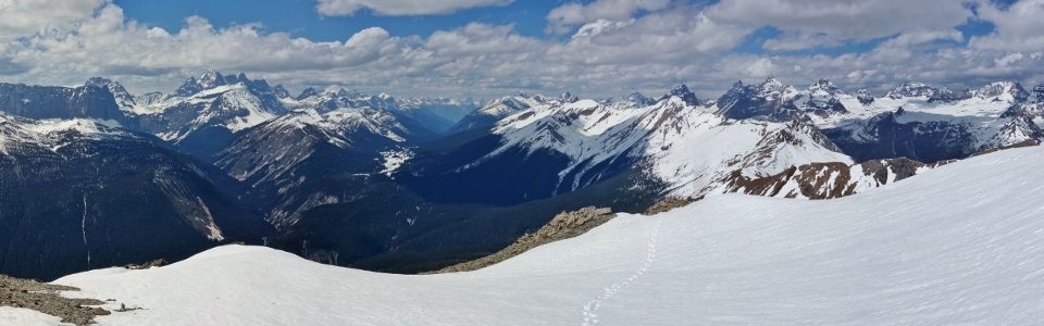
The spectacular 360-degree panorama from the summit of Ochre Spring Peak! Click and drag to have look around and save yourself the epic slog!
.jpg)
Matt C. takes in the view the striking Vermilion Range to the south.
.jpg)
The 2D summit panorama is almost as striking as the 3D version. This view essentially captures the entirety of the famous “Rockwall” backpacking route which follows the snowy alpine environs at the base of the Vermilion Range’s formidable rock walls. Click to see larger.
.jpg)
Tumbling Creek (right) flows into Ochre Creek (bottom) which then flows into the larger Vermilion River (left) at the foot of the Vermilion Range’s dramatic east-facing ramparts.
.jpg)
Telephoto towards the southern Vermilion Range: Mounts Whitetail (center left) and Verendrye (center) rise up beyond Numa Mountain (foreground right).
.jpg)
Floe Peak’s jagged summit ridge towers above Numa Pass.
.jpg)
Highway 93 accompanies the Vermilion River south towards Radium.
.jpg)
Enjoying the beautiful main range scenery (and summit) I’d been craving.
.jpg)
More proximate Vermilion peaks: Foster Peak (left) and Hewitt Peak (sometimes called Mammoth Peak) (right).
.jpg)
Hewitt Peak (left), Tumbling Peak (center) and Mount Gray (right) rise up above the Tumbling Creek Valley.
.jpg)
The aptly named Tumbling Glacier clings to the steep east face of Tumbling Peak.
.jpg)
Spring in the valleys and winter up high to the west.
.jpg)
Mounts Gray (left) and Drysdale (right) bookend Wolverine Pass which provides a sightline to the Bugaboos almost 70 km away.
.jpg)
An impressive 4 km-long ridge separates Mount Drysdale/Rockwall Peak on the left from Limestone Peak on the right.
.jpg)
Helmet Falls cascade down the lower slopes of Helmet Mountain to the west.
.jpg)
Summit selfie with the Ottertail Range and Valley to the northwest.
.jpg)
Ottertail giants Helmet Mountain (left), the Goodsirs (center) and Mount Vaux (right) provide a scenic backdrop to colorful (and hearty) summit moss campion.
.jpg)
The panorama to the north features 2 of the 3 highest peaks in the Southern Canadian Rockies: Mount Goodsir on the left and Mount Temple on the right (beyond the Ten Peaks). Click to see larger.
.jpg)
The Ten Peaks are oft-photographed from Moraine Lake and their dramatic north faces adorn postcards and paraphernalia all over the Rockies. From the south, however, these peaks are less recognizable and many barely jut above the extensive, high glacial bench which they share. Mouse over to see the less-seen side of the Ten Peaks (literally in reverse).
.jpg)
Taking in the amazing view towards Lake O’Hara and the Ten Peaks. From left to right: Curtis Peak, Mount Biddle, Mount Hungabee, Wenkchemna Peak, Neptuak Mountain, Deltaform Mountain, Mount Allen, Mount Perren, Tonsa Peak and Mount Temple (photo courtesy Matt C.).
.jpg)
Dramatic lighting on Mount Temple, the Fay Glacier and Peaks “2,” “3” and “4.”
.jpg)
Mount Fay (center left), Mount Quadra (center right) and Bident Mountain (right) beyond the Chimney massif.
.jpg)
One of the best things about the main ranges is that the panoramas to the east are just as awesome as the panoramas to the west! In fact, this eastern view actually features the continental divide as it passes along the Ball Range. Click to see larger.
.jpg)
Matt C. and I also considered nearby Chymper Peak (center left) as an objective for the day but were glad we made the choice that we did. Chymper’s obvious, snowy ascent bowl still looked far too snowy for a safe ascent in current conditions! To the right, Mount Whymper’s pyramidal summit captures the sun’s rays above Vermilion Pass.
.jpg)
Storm Mountain straddles the Alberta/British Columbia border.
.jpg)
Looking due east towards Stanley Peak and larger Mount Ball (immediately behind Stanley from this angle). The popular “Stanley Glacier” hike gains the valley near the waterfalls on the lower left of the photo.
.jpg)
Vermilion Peak (center right) and Mount Haffner (immediately left of Vermilion) rise above the sadistic Haffner Creek Valley (left).
.jpg)
After being cloaked in clouds for most of the day, the highest peak in the southern Canadian Rockies (Mount Assiniboine) makes a brief cameo about 50 km to the southeast. With this brief Assiniboine sighting, Matt C. and I could officially boast that we'd seen each of the 3 highest peaks in the southern Canadian Rockies - not bad for an early season scramble!
.jpg)
After enjoying the scenery from Ochre Spring Peak for over an hour, 2 "bold" Matts took a final group photo before prying themselves from the summit and entering GTFD mode.
.jpg)
Matt C. starts off down the upper mountain’s steep scree (much more pleasant to descend than it was to go up!).
.jpg)
Returning to the verdant lower valley. On descent, we (once again) avoided the unstable snow on the peak’s upper slopes. On the lower mountain, however, we were able to take advantage of hard-packed avi debris to make a rapid descent. While I used my bum to accomplish this, Matt C.’s delicate tooshie kept him on his feet. Regardless of conveyance, our descent back to the trail proved MUCH faster (1 hour and 50 minutes) than our scramble up from it (4 hours and 10 minutes)!
.jpg)
Once we were back to the trail, we enjoyed the lush forest and soft earth on a pleasantly quick hike back towards the “Paint Pots.”
.jpg)
The colorful “Paint Pots” were every bit as scenic in the afternoon as they had been in the morning and we, once again, spent more time than we ought to have photographing mud!
.jpg)
An ochre-colored spring trickles downslope towards fire-razed Vermilion Peak.
.jpg)
Ochre graffiti (quite possibly the only kind of graffiti which I approve of within the Parks) near the trailhead.
From the colored mud below to the spectacular 360-degree panorama above, we enjoyed everything about Ochre Spring Peak (except maybe the scree on the way up!). However, If the peak had been much snowier, our day would have been much different. On this day, fortune favored our bold early season foray into the main ranges. If you decide to make one of your own, be sure that you’re confident in your abilities to assess conditions on-the-go. In the mountains, fortune can either favor the bold or it can avalanche them right off the peak…
.jpg)
.jpg)
.jpg)