On August 8 2014, Grant and I stubbornly attempted to scramble up Vermilion Peak amidst pouring rain. We saw next to nothing that day and, after slogging 3/4 of the way up the peak, were promptly thundered off the mountain. Soaked and defeated, we made a hasty retreat as lightning flashed overhead.
Almost exactly 1 year later, we returned to Vermilion Peak (this time on a much nicer day!) with some unfinished business to attend to…
.jpg)
The highway-side view of Vermilion Peak. Vermilion’s steep slopes are littered with burnt timber as the result of a massive forest fire in 2003. The fire started following a lightning strike on July 31 and burned a 17,000 hectare area. Extraordinary measures were required to keep the fire from spreading to nearby Banff and Lake Louise. This event ultimately led to the establishment of creative fire-management policies in the mountain parks (including the use of prescribed burns).
.jpg)
Mere minutes above the road-side parking area, Grant and I found the overgrown remains of the old highway. To ascend Vermilion, simply make your way a couple hundred meters south down the road towards the massive avalanche gully which runs all the way down the peak’s west face.
.jpg)
The point at which you should leave the old highway behind is pretty obvious…
.jpg)
The profusion of colorful fireweed in this area is a welcome consequence of 2003’s events.
.jpg)
There’s no messing around with an approach on Vermilion. The peak’s huge avy gully allows you to get down to business (and to start gaining elevation) right away!
.jpg)
Grant follows a well-beaten path through the fireweed and up the gully under the early morning sun.
.jpg)
One of two rock bands about mid-way up; both are easily overcome.
.jpg)
At last, the peak itself is in sight! Don’t get too excited though – the view is extremely foreshortened! There’s still about 700 vertical meters separating us from the summit at this point…
.jpg)
Near the (burnt) tree line, we stopped for a snack and enjoyed the view of the Kootenay River Valley and Vermilion Range which was unfolding behind us. Click to see larger.
.jpg)
Blue skies over Mammoth Peak (left) and Tumbling Peak (right).
.jpg)
Aptly named Rockwall Peak and the Goodsirs to the west.
.jpg)
As Kane notes, the gully eventually splits near tree line. Although either branch will work, do yourself a favor and take the grassier right-hand branch! This branch avoids the treadmill scree, awful side-hilling and unnecessary elevation gain/loss that you’ll encounter if you follow the left-hand gully like we did.
.jpg)
Not as fun as it looks! As alluded to above, we followed the rockier left-hand gully and soon found ourselves groveling up steep terrain at the base of Vermilion’s cliffy summit. We completely avoided this nonsense on descent by sticking to a pleasant grassy bench which sits atop the other gully.
.jpg)
A group in front of us gains the ridge crest (a tad prematurely). Sick of side-hilling, we followed them up this line but easier lines exist just a little further to the south of here. While this terrain looked reasonable from below, it was more exposed than anticipated once you’re on it! Not helping matters, I dropped my hiking pole about halfway up and had to down climb some steep slabs to retrieve it. Although this terrain is avoidable, it’s actually a decent warm-up for the devilry that lies just ahead on the ridge crest.
.jpg)
From the ridge crest, the peaks of the nearby continental divide are spectacularly revealed for the first time. Click to see larger.
.jpg)
Grant starts up the ridge crest towards the summit – the ridge is pleasant and mellow initially…
.jpg)
…but soon both sides fall away steeply! The drop to the left, down near-vertical slabs, is particularly unnerving as is the flaky, sometimes rotten, nature of the rock along the crest. Expect difficult scrambling if you opt to tackle the ridge crest head-on.
.jpg)
While most scramblers seem to enjoy the challenge of the ridge crest, I opted to detour on steep, loose terrain to the right just before the summit. Grant followed the crest the whole way, thinking that my by-pass looked “sketchy.” For my part, I felt much safer below the ridge and wondered why people would subject themselves to the “sketchy” crest above! All a matter of preference, I suppose. Regardless of which way you go, don’t expect easy terrain near Vermilion’s summit!
.jpg)
Taking care of (unfinished) business atop Vermilion Peak!
.jpg)
Outstanding views of the continental divide from the summit. Even if we had made it up Vermilion amidst foul weather last year, we would have been completely deprived of these wonderful summit vistas! Click to see larger.
.jpg)
The headwaters of the Kootenay River at the base of Chimney Peak (right). Beyond the river valley, the many summits of the Valley of the Ten peaks rise up. From left to right: Mount Biddle, Mount Hungabee, Deltaform Mountain, Mount Allen, Mount Perren, Mount Little, Mount Temple, Chimney Peak, Mount Fay, Mount Quadra and Mount Bident.
.jpg)
Highway 93 crests Vermilion Pass at the foot of Mount Whymper (left).
.jpg)
Storm Mountain (left).
.jpg)
Hellacious Haffner Creek winds its way up the valley between Stanley Peak (left), Beatrice Peak, Mount Ball (center) and Mount Haffner (right).
.jpg)
A closer look at Stanley Peak. Kane’s difficult and exposed route goes straight up the west ridge (center) while the more moderate (and more popular) south ridge ascent follows the right-hand skyline.
.jpg)
The remote basin at the headwaters of Haffner Creek and the foot of massive Mount Ball (left). This valley is a beautiful place to spend a night or two but getting there is really, really unpleasant!
.jpg)
Sharing the summit with a friendly and carefully arranged (for this photo anyways) CSMC meet up group (photo courtesy CSMC).
.jpg)
Mingling with the CSMC group. It was very nice to meet Billy, Jag, Ella and all of the others with them. While several of the men in the CSMC group were quite interested in my website, the ladies seemed more interested in hearing about Grant’s band…guess I should have learned to play guitar instead of learning to code HTML! (Photo courtesy CSMC)
.jpg)
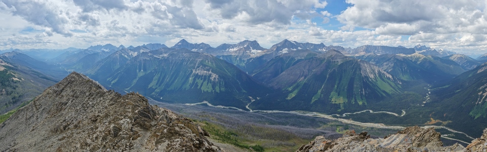
The Kootenay River winds its way south along the foot of the impressive Vermilion Range. Click to see larger.
.jpg)
A fresh dusting of snow on “the Matterhorn of the Rockies” – Mount Assiniboine is visible beyond Simpson Ridge (left), Hawk Ridge (right) and Mount Schanks (far right).
.jpg)
Looking south towards Numa Mountain (far left), Floe Peak (center left) and impressive Foster Peak (center right).
.jpg)
Small glaciers persist along the base of Mammoth Peak’s sheer east face. Several of the famous Bugaboo Spires are just visible in the distance on the far right.
.jpg)
Tumbling Peak (left) and Mount Gray (right).
.jpg)
The Mount Goodsir massif beyond Rockwall Peak (left) and Sharp Mountain (center). Glaciated Mount Vaux is also visible beyond Martins Peak and Mount Ennis (right).
.jpg)
The ochre paint pots from which the vermilion associated with this valley orginates.
.jpg)
The CSMC group begins their descent. Grant and I would follow very shortly thereafter.
.jpg)
Looking down towards the grassy bench from Vermilion’s summit ridge. On descent, we avoided the nasty scree gully and enjoyed easy travel through these alpine meadows towards the descent gully (far right).
.jpg)
Pleasant strolling in alpine meadows – certainly preferable to the loose scree side-hilling that we endured on ascent!
.jpg)
Enjoying impressive scenery as we descend back towards the main avalanche gully. 366 days after Vermilion Peak first thwarted us, I’m very pleased that Grant and I were finally able to enjoy the views from this picturesque peak!
.jpg)
.jpg)
.jpg)
.jpg)