Clubs Peak
Elevation: 1945 m
Elevation Gain: 290 m
Clubs Peak is one of several unofficially named high points along or near Hastings Ridge just south of Hillcrest, AB. Collectively, these high points, which include Spades Peak, Hearts Peak, Diamonds Peak and Poker Peak, are referred to as the “card peaks.” It’s possible that these peak names came into being as the result of their proximity to officially named Maverick Hill, which is also nearby. Hastings Ridge is also officially named for Tom Hastings, a member of the 1884 Geological Survey Party.
My Ascents:
August 28 2023
Trailhead: Adanac Road Pass (Pullout)
GPS Track: Clubs Peak
After three fun, huckleberry-filled nights camping with our families near the Old Man Dam, we reluctantly packed up our sites and readied ourselves to check out on Monday August 28. With our trip at an end, we were faced with the imminent (and unpleasant) prospect of returning to work and school. Needless to say, we weren’t in any rush to get back. With a view towards putting off the inevitable, we therefore decided to stop for a family hike along the way home.
Several years earlier, I’d scouted the Adanac Road approach to the “card peaks” near Crowsnest Pass and was 85% certain that we could make it up and park at their trailhead with our camping trailer. 🫣 These peaks had been on my family hiking wish list for years and were reasonably close to the campground we were leaving, so we decided to “ante up” and find out if they were feasible on-the-way-home-from-camping objectives or not! 🤷
.jpg)
After a bumpy 10-minute drive up Adanac Road to a high pass, I was elated to discover that the roadside pullout there was wide enough to pull a U-turn with a trailer. 😁 Suffice to say, I’d been confident that we could pull our trailer up this mountain road but was much less-so in my ability to complete a 3-point turn at the top if it was required! Happily, the road also proved feasible for my parent’s 40-year-old VW camper van, so we were able to “deal them in” on “this hand” as well! ♣️♦️♠️♥️
.jpg)
From the pass-top pullout parking, we followed a slightly smaller dirt road west. Having not hiked in the area for several years, I was pleased to discover an abundance of recently erected signs which made route-finding incredibly easy.
.jpg)
For the first kilometer-and-a-half, we followed the gently rising road across south-facing slopes. While these provided fine views deeper into Castle Provincial Park, they were also scorching on this hot August morning. ☀️🫠 Click to see larger.
.jpg)
Hot and hazy views south into Castle. If you recognize silhouettes, familiar peaks include: Castle/Windsor Mountain (left), Carbondale Hill (center left midground), West Castle Mountain (center), and Barnaby Ridge/Southfork Mountain (center right).
.jpg)
.jpg)
LEFT: A pokey Penny begrudgingly hikes along the road as it winds its way away from the trailhead below Poker Peak. I’m not sure if it was the heat or just apathy but Penny was ready to give up and “fold” on this hike right from the start… 🙄😒
RIGHT: After a kilometer-and-a-half, the road turned sharply to the north and made its way through a brief forest.
.jpg)
Grandpa stops to consult the excellent signage at an intersection 2-km from the trailhead. To the left, a short road leads towards Clubs Peak and Diamonds Peak (also called South Hastings Ridge). To the right, a longer road leads towards Spades Peak. With the temperature soaring and Penny making a fuss, we decided to aim for the shortest of these options: Clubs Peak.
.jpg)
Half a kilometer from the intersection, we reached the well-marked route up Clubs Peak ♣️, where things took an abrupt turn for the steeper! 😲 While Penny and Grandma didn’t love the look of this final slope, we were “all in” at this point.
.jpg)
Grandpa and Brianne enjoy steadily improving views to the west from Clubs Peak’s final, steep slopes.
.jpg)
.jpg)
LEFT: Grandma grits her teeth and readies herself for the final grind up the peak. 😬
RIGHT: Brianne (and Lillian) attack the steep but mercifully short summit slope. 🚀
.jpg)
.jpg)
LEFT: After the hot, steep hike up, Grandma earned a summit nap 😴 in the shade, while Brianne took a load off and said load enjoyed some lunch. 🥪😂
RIGHT: While Brianne, Grandma and Lilly rested in the shade, Mera and Penny explored and discovered a ribbon tree on the east side of the summit.
.jpg)
To the east, Hastings Ridge filled the summit panorama, stretching from the left of this image all the way to its right. Click to see larger.
.jpg)
Looking north towards nearby Spades Peak (center left), Hillcrest Mountain (center) and the north end of Hastings Ridge (right).
.jpg)
A busy day on the road to Spades Peak! It’s a good thing that we decided to do Clubs Peak today as the Hobbs family are not fans of bovine hiking encounters! 🐮
.jpg)
Looking east towards Poker Peak - an enticing hike for our next camping trip in the area! 🤔
.jpg)
Hazy views southeast towards Maverick Hill, Mount Backus and more distant Prairie Bluff.
.jpg)
Victoria Peak highlights the rolling sea of mountains to the south.
.jpg)
A more panoramic view of the Castle Wilderness peaks to the south, beyond the South Peak of Hastings Ridge (aka: Diamonds Peak). Click to see larger.
.jpg)
Looking beyond the abandoned open pit mine on Diamonds Peak towards Syncline Mountain and the West Castle Valley.
.jpg)
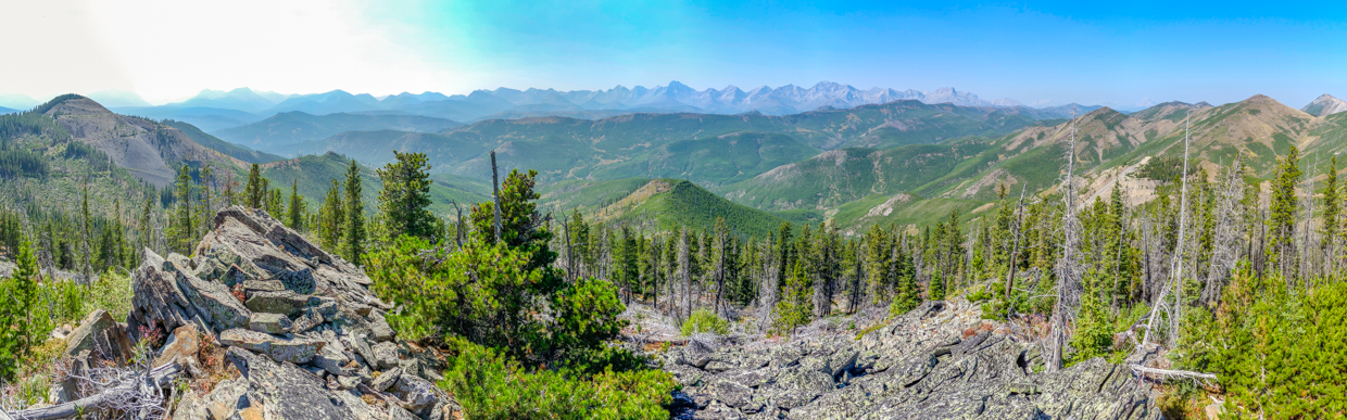
A small rocky outcrop to the west of the summit provided the best panoramic views in that direction towards the impressive Flathead Range. Click to see larger.
.jpg)
A telephoto panorama towards the dramatic east face of the Flathead Range. Click to see larger.
.jpg)
A closer look at Mount Darrah (right): the second-highest peak in the Flathead Range and the most eye-catching from Clubs Peak.
.jpg)
Views north towards and beyond another mine near Spades Peak.
.jpg)
Although it was only 26-km away, Crowsnest Mountain’s characteristic profile was only faintly visible to the northwest on this hot and hazy afternoon.
.jpg)
Hot and hazy Hobbses On Top of yet another peak.
.jpg)
After summit naps, explorations, photography and lunches, the time to descend arrived and we discovered that the steep sub-summit slopes were just as challenging to descend as they had been to go up! 🫣
.jpg)
Below the steepest slopes, the going got easier and Mera and Penny raced 🏃♀️ well ahead of us, eager to get down to the pass between Clubs and Diamonds as quickly as possible. At the pass, we faced a quandary. Mera was SUPER keen to investigate the mine on nearby Diamonds Peak while Penny was even more eager to get back to the trailhead for a cold treat. The solution: Mera and I would hike towards the old mine at a good pace, while the rest of Team Hobbs would enjoy a more relaxed hike back to the cars.
.jpg)
.jpg)
LEFT and RIGHT: From the pass, my aspiring miner and I followed another road along the east slope of Diamonds Peak.
.jpg)
After about 700 meters, this easy road deposited us on the south ridge of Diamonds Peak just above the old mine. Having cut away a good bit of the mountain and its forests, this old mine offered even more open, panoramic views than the summit of Clubs Peak had. Click to see larger.
.jpg)
From where the road met the south ridge, the mine and the summit of Diamonds Peak looked to be about equally close (but in opposite directions). Since Mera had been so good all day, I asked her if she’d rather visit the mine or the summit and she excitedly chose the former, hoping to find some natural treasure... 💎
.jpg)
Mount Darrah makes another impressive appearance from the lip of the old mine.
.jpg)
“Mining” with Mera. ⚒️ While she’d hoped to find geodes or something similarly dramatic, she was somewhat disappointed to discover that this had been a coal mine. Still, we decided to make the best of it and explored about for the “prettiest” pieces of coal that we could find to bring back for her, Penny and Lillian 👶 (because what infant doesn’t covet carbon-rich coal)? 🤣
.jpg)
After we’d extracted the coal that we “needed,” we started to hike back up out of the mine, enjoying hazy views towards Crowsnest Mountain along the way.
.jpg)
Once we returned to the road, my minor coal miner and I enjoyed a speedy 3-km hike back to the trailhead. ❤️
.jpg)
Back at the trailhead, we reunited with the rest of our family, who were making the most of the shade that the trailer provided, while lightening our load by consuming that which remained in our beverage cooler. 🍺🧃 As the cooler ran dry, we reluctantly packed up again and, this time, actually headed home to deal with the sad reality that is back-to-school/work. 😔 At the very least, however, we’d be “cashing out” with another peak and a beautiful day together under our belts. 😊
.jpg)
.jpg)
.jpg)
.jpg)
.jpg)
.jpg)