Although it’s been over a year since Brianne and I were engaged, we had only now gotten around to organizing an outing to have engagement photos taken. Of course, these would have to be taken in the mountains! In an effort to look our best, we dressed up in our finest (jeans and white shirts) and Brianne even paid to have her hair and makeup professionally done (damn she looked amazing). After carefully coordinating with our photographer, we made our way to Upper Kananaskis Lake Thursday after work. Turns out that we didn’t coordinate carefully enough, however (who knew that there were TWO DIFFERENT “Upper Kananaskis Lake” parking lots about 1 km apart)! As a result, our photographer sat in 1 parking lot for over an hour wondering where his clients were and we sat in another lot a short distance away wondering where the hell our photographer was. Without the benefit of cell phone service, we never did meet up. Disappointed, but wanting to make the most of a bad situation, Brianne, Crux and I checked into the Lower Lake campground as the sun was setting and decided to enjoy a campfire, a few beers and an ascent of nearby Tent Ridge the next morning.
.jpg)
Like many outings in the Spray Lake/Smith-Dorrien area of Kananaskis, the ascent of Tent Ridge involves an approach hike on a convoluted and overgrown network of old logging roads and cutlines. We tried our best to follow Gillean Daffern’s directions in an effort to not get lost and it would seem that we succeeded. The parking area 1.8 km from the highway turnoff was easily found and we ignored the obvious trail visible down the road from it (as it turned out, we would end up descending this trail). From the parking area, we followed the directions in the guide and walked back along the road a short distance before turning right up the grassy logging road in the photo.
.jpg)
Within 10 minutes of leaving the road, we found this small trail marked with a cairn on the right hand side of the grassy logging road and took it. There are several forks in the trail and, if memory serves, we took the left-hand fork at each one regardless of how much flagging tape adorned the trees going in the other direction (I don't even recall seeing the "four-way" intersection that Daffern describes...). Regardless, our route worked exactly as hoped.
.jpg)
As you can see, this trail is quite bushy! Not quite bushwhacking but not far off!
.jpg)
There was a ton of deadfall along the trail, most of which we were able to step over. In a couple of places the logs were too large for Crux to safely hop over and we had to lift him. This was, of course, complicated by what sounded like a very large animal thrashing through the bushes nearby at one point. Needless to say, we quickly threw Crux (and ourselves) over the logs blocking the path at that point and didn’t stick around to investigate the source of all the noise.
.jpg)
After (somehow) successfully navigating the labyrinth of overgrown trails, we successfully found our way into Monica Brook located in the center of horseshoe shaped Tent Ridge. Ahead (behind the trees) you can see the high point of the ridge. We followed a good path past the open alpine basin ahead of Brianne and up the slope on the left (east) side.
.jpg)
Pretty wildflowers around Monica Brook.
.jpg)
Enjoying the view of Tent Ridge’s west slopes from the open alpine basin. We went up the east slopes directly opposite these.
.jpg)
Ascending the east slopes through thinning larch forest, the Tower, Mount Galatea and Mount Chester come into view.
.jpg)
Making our way up the Rubble slopes and looking toward our objective across Monica Brook basin, the highpoint of Tent Ridge, with the Fist and Mount Smuts beyond.
.jpg)
Another group of 2 people and their dog (about 20 feet to the right of the people in the photo) was already on the summit as we started to make our way up the ridge. Looks like someone got a more alpine start than us. I blame our lazy dog!
.jpg)
Brianne negotiating one of the east ridge’s “scrambly” bits. The “scrambling” sections of the ridge were quite benign and you could mostly avoid any “hands-on” scrambling by detouring either right or left a short distance. There was no exposure.
.jpg)
Pausing along the ridge near the first high point to enjoy the rapidly improving view.
.jpg)
A beautiful panorama from the first highpoint. From left to right: the Fist, Mount Smuts, the true summit of Tent Ridge, Mount Shark, the north summit of Tent Ridge, Mount Fortune, Spray Lake, Mount Nestor, Old Goat Mountain, Mount Buller and the Tower. Click to see larger.
.jpg)
Great views of Mount Birdwood, the Fist and Mount Smuts from the first highpoint.
.jpg)
Other than the vicious bushwhack involved to get up, the Fist was a thoroughly enjoyable ascent!
.jpg)
Tryst Lake sparkles in the sun below the Fist.
.jpg)
Old Goat Mountain and Mount Nestor across Spray Lake.
.jpg)
Mounts Lougheed, Buller, Sparrowhawk and Engadine to the north-east.
.jpg)
The distinctive block shape of Mount Lougheed.
.jpg)
Brianne demonstrating proper posture while enjoying a sandwich next to the orange repeater station Space Command Station. Crux looks on jealously.
.jpg)
Mount Engadine, the Tower and Mount Galatea above the marshy valley and the Mount Engadine Lodge below.
.jpg)
The Mount Engadine Lodge, which is apparently for sale! If only I had $2 million burning a hole in my pocket...
.jpg)
The Tower mocking me while it continues to hold my wallet captive.
.jpg)
The highest point of the Kananaskis Range: Mount Galatea.
.jpg)
Standing at attention at the Space Command Center.
.jpg)
Brianne grew tired of my Space Command Center-related shenanigans and decided to start moving on towards the true summit of Tent Ridge.
.jpg)
Making her way up to the summit. The SCC on the highpoint behind her and tiny Tryst Lake below.
.jpg)
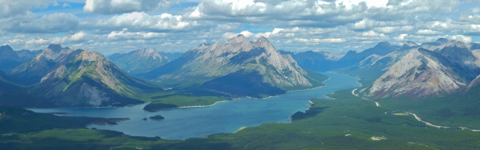
The view from the summit: Tent Ridge on the left and Tent Ridge on the right. We ascended the grey slopes on the right and will traverse the entire length of the ridge on the left before eventually descending towards Spray Lake. Click to see larger.
.jpg)
Brianne enjoying the splendid summit viewpoint.
.jpg)
Crux, likewise.
.jpg)
The panorama of many larger summits to the south. Click to see larger.
.jpg)
Peaks to the south: Cegnfs, Mount Murray, Mount Smith-Dorrien, Mount Burstall (foreground), Commonwealth Peak (foreground), Mount French and Mount Sir Douglas.
.jpg)
Looking along the connecting ridge to the Fist and Mount Smuts. Mount Birdwood and Snow Peak beyond the Fist – Smuts col.
.jpg)
Mount King George faintly visible in the distance.
.jpg)
Looking beyond Mount Shark (left) down the valley between Mount Turner and Cone Mountain with tiny Watridge Lake in the foreground.
.jpg)
A distant Mount Ball can be seen down the Bryant Creek Valley.
.jpg)
In the absence of professional engagement photos, I suppose this will have to do!
.jpg)
Looking back to the summit after a long and scenic walk along the west ridge.
.jpg)
The panorama from the third and final highpoint of Tent Ridge. From left to right: Mount Smuts, Mount Shark, Mount Morrison, Mount Assiniboine (distant), Mount Turner, Cone Mountain, Mount Fortune, Old Goat Mountain, Mount Nestor, Spray Lake and Mount Buller. Click to see larger.
.jpg)
Mount Assiniboine and Watridge Lake.
.jpg)
Telephoto of Mount Assiniboine.
.jpg)
Making our way down the ridge towards Spray Lake. Click to see larger.
.jpg)
Final shot on top of the ridge before heading down into Gawby Gulch.
.jpg)
Brianne in a hurry to get down – likely due to the cold beers waiting for us in the cooler in the parking lot…
.jpg)
From the final cairned high point on the ridge, we descended a steep trail into Gawby Gulch directly below. There is another trail from this point (the Tent Ridge Connector) which side hills along the slope back to the south and into Monica Basin. We, however, found the Gawby Gulch trail to be a pleasant way down which avoided the gratuitous deadfall which littered our approach trail.
.jpg)
The side-hilling Tent Ridge Connector trail.
.jpg)
Descending a good trail in Gawby Gulch. At the first fork in the trail, we stayed skier’s left on what appeared to be a more well-worn trail which went uphill for a moment before turning back down the hill. This trail eventually brought us to a T-junction with (another) grassy logging road. We followed this road to the skier’s right and, 10 minutes later, we were back at the parking area. Somehow, despite our best efforts, we failed to get lost on either ascent or descent!
.jpg)
Crux enjoys a cool drink from a now-suspiciously empty cooler.
.jpg)
.jpg)
.jpg)
.jpg)
.jpg)