Following a year of marital bliss, Brianne and I decided to mark our first anniversary by returning to the scene of the crime our wedding: beautiful Lake Louise. With a hotel room booked for the weekend, we set out to celebrate the only way that we know how – by bagging a peak!
Since the Eiffel Tower is considered one of the most romantic attractions on Earth, we thought it might be nice to spend our anniversary gazing out upon it. On this beautiful fall day, our ascent of Eiffel Peak put us in the perfect position to do so (you didn’t think I was talking about that ugly French heap of metal, did you?)!
.jpg)
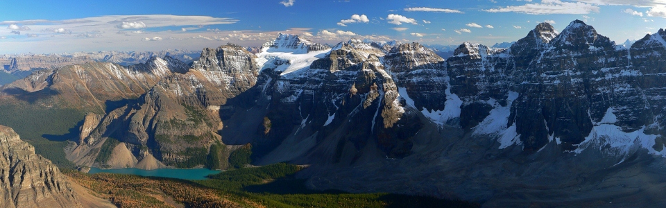
After sweating our way up the forested switchbacks from Moraine Lake, our early morning effort was immediately rewarded with the stunning view of the Valley of the Ten Peaks (Mount Perren, Mount Allen, Mount Tuzo, Deltaform Mountain and Neptuak Mountain pictured here) from golden Larch Valley. A few minutes beyond this point, we escaped the busy trail near a small creek as described by Kane.
.jpg)
Making our way through the colorful forest – there’s no better time to visit Larch Valley than the third weekend of September when the entire area appears to be aflame in golden autumn color.
.jpg)
Brianne makes her way into the alpine as Eiffel Peak comes into view.
.jpg)
At the base of Eiffel’s southeast ridge, we left the trees behind and were treated to a spectacular panorama Larch Valley nestled between Eiffel Peak (left), Pinnacle Mountain (center) and Mount Temple. Click to see larger.
.jpg)
Wenkchemna Pass and a sea of larches come into view as we work our way upwards.
.jpg)
Romantic getaway!
.jpg)
Above the lower rubble slopes, the upper mountain comes into view. The route sticks close to the ridge until traversing left underneath the large buttresses on the top right. A series of gullies then leads up to the left of the buttresses and on to the summit. If you squint, you can just make out 2 other scramblers on the upper rock band left of the buttresses; it would seem that someone got a more alpine start than we did.
.jpg)
The “Goat” at home on the upper mountain’s steeper slopes. As the quality of the scrambling improved, so too did the view!
.jpg)
The easy (but loose) gully that allows you to by-pass the buttress.
.jpg)
Brianne makes her way to the top of the gully as the panorama unfolds on either side of the buttress. Click to see larger.
.jpg)
Brianne pauses to catch her breath and take in the view of Pinnacle Mountain and Mount Temple from high up on Eiffel Peak.
.jpg)
The final obstacle before the summit – another gully. The easiest route up follows the loose, moist rock on the left, however, other lines up are possible as well. From this point on, the summit is actually only 10 minutes away!
.jpg)
Happy to be on top!
.jpg)
Paradise Valley panorama – from left to right: Wastach Mountain (foreground), Mount Vaux (distant), Mount Hungabee, Ringrose Peak, Glacier Peak, Mount Lefroy, the real Eiffel Tower, Mount Aberdeen, Mount Hector (distant), Haddo Peak, Sheol Mountain, Pinnacle Mountain (foreground) and Mount Temple. Click to see larger.
.jpg)
The Horseshoe Glacier and Horseshoe Lakes at the base of Mount Hungabee. Wastach Mountain’s ultra-steep ascent slopes visible in the foreground below.
.jpg)
A fresh dusting of snow on Mount Hungabee. Lake O’Hara landmark Mount Biddle is just visible on the far left behind Hungabee’s shoulder.
.jpg)
Ringrose Peak.
.jpg)
Eat your heart out Paris.
.jpg)
Yours truly.
.jpg)
Mount Temple separates green Paradise Valley (left) from golden Larch Valley (right). Click to see larger.
.jpg)
Mount Aberdeen and Haddo Peak preside over Paradise Valley.
.jpg)
Enjoying a happy anniversary high above Moraine Lake.
.jpg)
A (justifiably) crowded day down in Larch Valley! When I zoomed in on the high-res version of this picture, I was able to count at least 150 hikers along this ~1 km stretch of trail below. Assuming a similar density elsewhere along the 6 km trail, that means that nearly 1,000 people were on the Larch Valley trail at the instant this photo was taken. High above, however, Brianne and I enjoyed the summit to ourselves for 45 minutes!
.jpg)
Larches also dot the flank of Panorama Ridge beyond Moraine Lake and the Tower of Babel.
.jpg)
The long ramparts of Castle Mountain separate the main ranges from the front ranges (including Mount Aylmer in the distance on the center left).
.jpg)
The Valley of the Ten Peaks panorama. From left to right: Panorama Ridge, the Tower of Babel, Mount Babel, #1) Mount Fay, #2 and #3) Mounts Little and Bowlen, #4) Mount Tonsa, #5) Mount Perren, #6) Mount Allen, #7) Mount Tuzo, #8) Deltaform Mountain, #9) Neptuak Mountain and the distant Mount Goodsir. The tenth peak (Wenkchemna Peak) is actually separated from the others by Wenkchemna Pass and is not visible here. Click to see larger.
.jpg)
Mount Fay and the beautiful Fay Glacier.
.jpg)
Looking beyond the Ten Peaks towards Chimney Peak (left) and glaciated Mount Ball (center).
.jpg)
The Wenkchemna Glacier plunges down the impossibly steep face of Deltaform Mountain.
.jpg)
Wenkchemna Pass separates smaller Neptuak Mountain (left) and Wenkchemna Peak (right) from their larger siblings Deltaform Mountain and Mount Hungabee, respectively. The more distant panorama features massive peaks of the Ottertail Range including Mount Goodsir (center left), Chancellor Peak (center) and Mount Vaux (center right). Click to see larger.
.jpg)
The Goodsir massif – Mount Goodsir is the second highest peak in the southern Canadian Rockies.
.jpg)
Mount Vaux.
.jpg)
My beautiful wife!
.jpg)
A first anniversary summit shot with Mounts Hungabee and Lefroy before making our way back down towards the hordes below.
.jpg)
Perfect timing! As we left the summit, we passed another group making their way up some challenging terrain moments below (note: this terrain is avoidable).
.jpg)
Below the gullies and buttresses of the upper mountain, we followed the long southeast ridge down towards Moraine Lake below.
.jpg)
Happy wife – happy life!
.jpg)
Deltaform Mountain makes for some scenic boulder hopping lower down.
.jpg)
From boulders back down to larches…
.jpg)
Making our way back through the vibrant forest.
.jpg)
A final panorama of the Ten Peaks from Larch Valley before elbowing our way down the crowded trail to Moraine Lake (click to see larger)! How lucky am I that this is my wife’s idea of romance? Happy anniversary Brianne!
.jpg)
.jpg)
.jpg)
.jpg)
.jpg)
.jpg)
.jpg)