“Limestone Mountain could very well be the least impressive-looking lump of rock called a summit in the area.”
-Andrew Nugara
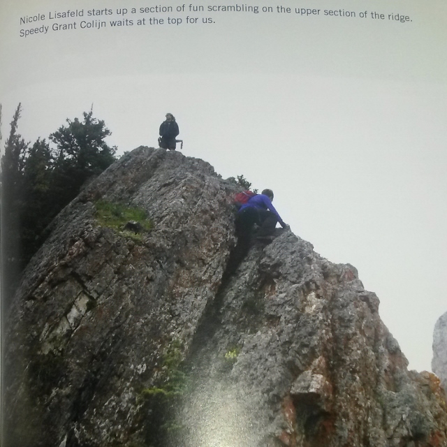
With songs of “praise” like this in Nugara’s new edition of “More Scrambles in the Canadian Rockies,” how could mighty Limestone Mountain not race to the top of my “to-do” list? Inspired by Andrew’s new write-up (featuring COLOR photos of the legendary and “speedy Grant Colijn”), I was compelled to bag this monstrous (580 vertical meter) Kananaskis behemoth.
OK. Truth be told, the forecast was calling for rain and I was keen to bag a quick and easy summit nearby (sorry Speedy Grant Colijn). Fortunately, Limestone Mountain proved to be an enjoyable outing featuring some fun hands-on scrambling and excellent summit views (even if the ascent itself won't totally amaze my friends).
.jpg)
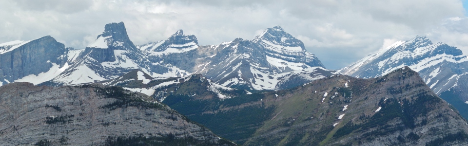
From the parking area near Rocky Creek, tiny Limestone Mountain (left) appears somewhat insignificant next to the larger Wedge (right). Despite its lowly stature, Limestone proved to be a very enjoyable (half) day out!
.jpg)
After attempting to follow a series of goat/hiking trails through the forest, I eventually found this poorly decorated Christmas tree (I guess Santa isn't even trying anymore).
.jpg)
Following what I can only presume was a path left by Santa Claus (or perhaps an elf), I quickly gained elevation, leaving Rocky Creek in the valley below.
.jpg)
After narrowly dodging a horrific patch of alders, the forest eventually thinned and I found myself staring down this STEEP (capitalized for EMPHASIS) grassy slope.
.jpg)
At the top of the STEEP (capitalized for EMPHASIS) grassy slope, I gained the south ridge of Limestone Mountain and found a lovely spot to enjoy a cup of tea and a snack.
.jpg)
Following tea-time, I resumed the ascent, enjoying some good hands-on moderate scrambling along the ridge.
.jpg)
The crux of the ascent involved ducking under the trees in the top left of this photo (an awkward but easy move).
.jpg)
Beautiful alpine terrain below the ridge connecting Limestone Mountain and the Wedge.
.jpg)
While the scramble up the south ridge is enjoyable, it is (regrettably) short. All too soon, one is greeted by wonderful views of Mount Kidd’s south (left) and north (right) summits from the top of Limestone Mountain.
.jpg)
Clouds collect on the lofty summit of Mount Kidd.
.jpg)
Enjoying one of the finer summit panoramas that you’ll find for a mere 580 vertical meters of effort.
.jpg)
Mount Lawson (left) and Mount Inlexible (right) to the south.
.jpg)
A picturesque outlier of Mount James Walker directly across the Kananaskis Valley.
.jpg)
The aptly titled Fortress.
.jpg)
The highest point of the Kananaskis Range: Mount Galatea.
.jpg)
The Tower taunts me while making purchases with MY credit cards.
.jpg)
Kananaskis Range panorama – from left to right: Mount Lawson, Mount Inflexible, Mount James Walker, the Fortress, Gusty Peak, Mount Galatea, the Tower and Mount Engadine. Click to see larger.
.jpg)
The Spoon Needle separates the Kananaskis River from the Kananaskis Range.
.jpg)
The Kananaskis River winds its way through the valley below.
.jpg)
Looking south towards Opal Ridge.
.jpg)
Larger peaks over the Kananaskis Lakes to the south.
.jpg)
Summit photo with the Wedge.
.jpg)
A closer look at the Wedge.
.jpg)
Panorama looking north along the Kananaskis Valley. Click to see larger.
.jpg)
Tiny Wedge Pond (left) below the Wedge (right). Click to see larger.
.jpg)
A closer look at Wedge Pond – wait…what’s that white speck in the center foreground?!
.jpg)
GOAT! GOAT! GOAT! OMG it’s a GOAT!
.jpg)
Although I had no intention of completing the easterly “extension” described by Nugara, I decided to down climb this steep terrain on Limestone Mountain’s east face to try to get closer to the GOAT that I spotted below. Despite appearances, the down climb was actually pretty fun!
.jpg)
After down climbing the first rock band (pictured above), this crack provided easy access through the lower rock band on the east face of Limestone Mountain.
.jpg)
Looking back up at Limestone Mountain after descending to the north ridge in search of the GOAT! Mouseover for route.
.jpg)
Of course. The entire time that I down climbed steep terrain in the hopes of getting closer to the GOAT for an amazing photo, the GOAT watched. He waited. He bided his time, amused by my relative clumsiness on the cliffs above. As soon as I got down – he split.
Without so much as a GOAT to show for my efforts, I wasn't keen to climb back up to the summit in order to descend the usual south ridge (scramble) or northwest ridge (hike) routes.
Looking down the north ridge, I reasoned that if GOATS could get up this way, I could get down this way; and so, I started my exploratory descent of the north ridge.
.jpg)
Flowers encountered during my reconnaissance of the north ridge.
.jpg)
The (as far as I know previously undescribed) descent of the north ridge proved simple, pleasant and disappointingly GOATless. Towards the bottom, more unusual Christmas trees were discovered suggesting that Santa (or an elf) favors this particular route.
.jpg)
Although I was concerned that the north ridge descent would result in unnecessary bushwhacking, it actually funnelled very nicely into a series of cut lines which led back to the highway (pictured here) just north of the Galatea exit. From here it was just a short 3 km jog back to my car (note to self: jogs in hiking boots are never short).
.jpg)
That highway-side jog seemed like the safest part of my day until I saw this fellow. No matter; he hardly noticed me amongst the “Bear-Jam” hordes pulled over to take photos!
.jpg)
.jpg)
.jpg)