Towering majestically above beautiful Bow Lake, Crowfoot Mountain’s glacier-clad ramparts are one of the Icefields Parkway’s scenic highlights (and the competition is fairly stiff along Highway 93N). Indeed, the roadside pullout near the peak’s base is often filled with tour buses and their ensuing throng of camera-toting tourists. Like them, I’ve been awed by Crowfoot for its aesthetic appeal. Having admired it from many angles atop nearby mountains, I’ve often thought about standing atop it and looking down, past the formidable glacier which occupies an impressive sub-summit bench, towards Bow Lake’s cerulean surface.
Aware that mountaineers and ski mountaineers ascend via a glacier on the backside, I resigned myself to the fact that it was outside of the scope of my scrambling skills. When I started looking into Crowfoot more seriously, however, I noticed that the glacier on its backside wasn’t terribly large; in fact, it looked like it might be all-together avoidable. This suspicion was confirmed in October 2015 when Doug Lutz and Brandon Boulier posted Facebook/YouTube trip reports from their non-technical class 3 scramble up Crowfoot. Since then, I’ve been waiting for a free day, a good weather window and a willing climbing partner to head out to see that, oft imagined, summit view in-person.
After a dreary fall, a run-in with a bad cold and an extremely busy month at work, it looked like I’d finally get my chance. Despite a blizzard-filled weekend, Tuesday and Wednesday looked to offer spectacularly clear skies and good weather so I made good use of a vacation day, hoping that it hadn’t snowed too much along the Icefields Parkway. While many of my usual climbing partners were unavailable for a midweek scramble, I was pleased to be joined by Dr. Phil (no – not that Dr. Phil) for a late-season attempt on Crowfoot Mountain.
.jpg)
What all the fuss above is about. A spectacular view of Crowfoot Mountain (taken from across the valley during a snowshoe ascent of Crystal Ridge in 2015).
.jpg)
Morning mist dances over Bow Lake in the faint pre-dawn light. Needing to be home by 10:00pm so that my wife could go to work without leaving our sleeping baby girl alone, Phil was good enough to accommodate my request for a very alpine start. We left Calgary at 3:30 am and arrived at Bow Lake to find the usual views replaced by pitch black and a starry night. After making our way 2 km around the lake’s north shore by headlamp, there was finally enough light to glimpse the northern end of the Crowfoot massif. The summit (located at the peak’s far south end) is 4 km beyond the high point visible here.
.jpg)
Phil navigates the snowy outwash flats beyond the lake by headlamp. Although we knew we’d run into snow at some point, it was disconcerting to find so much of it already piled up over a 1,000 meters below our ultimate destination!
.jpg)
Following the (all-too familiar) Bow Hut trail up a series of ICY steps. Making it up and down these steps without slipping and falling ass-over-tea-kettle may well have been the crux of the day!
.jpg)
Climbing up and over the icy chockstone which bridges a chasm wasn’t particularly straightforward in these conditions either.
.jpg)
Once we clawed our way up the slick chockstone, we were at least treated to a nice view of the nascent Bow River and the peaks across the Icefields Parkway.
.jpg)
Following the Bow Hut trail upstream, we reached the icy moonscape beneath Portal Peak and Mount Thompson as the first rays of daylight began to color the cloud and peaks above.
.jpg)
A wintry scene looking back downstream. The only thing more fun than boulder-hopping along this section of trail is boulder-hopping through fresh snow along this section of the trail.
.jpg)
Following the trail as it contours south along Crowfoot Mountain’s southwest face.
.jpg)
Mount Jimmy Simpson aflame in early morning light. With this view at our backs, our progress slowed as we paused frequently for photos.
.jpg)
A closer look at Mount Jimmy Simpson (center) and the, suddenly popular and recently named, “Jimmy Junior” (right).
.jpg)
Phil pushes through ever-deepening snow as St. Nicholas Peak comes into view.
.jpg)
“Two roads diverged in a wood, and I took the one less travelled by.” After following the Bow Hut trail for 6.1 km, we reached this creek and embarked up its left bank leaving the more popular trail behind. We had thought that we’d be breaking trail from this point on but, mercifully, a skier had laid down a skin track through the woods ahead the day prior! (And no, the sun didn’t suddenly rise – this photo was taken on descent.)
.jpg)
The north end of Crowfoot Mountain rises above a natural “waterslide.”
.jpg)
Phil proceeds past a final stand of trees towards the false summit of Crowfoot Mountain (the high point haloed by the rising sun in the center of the photo). From here the route side-hills up rocky ramps towards the false summit, avoiding the glacier which rests (hidden today) in the valley ahead. When dry, avoiding the glacier should be a trivial matter but in these conditions, it helps to have a GPS track (thanks Doug!).
.jpg)
Sun-kissed Wapta Icefield peaks provide the day’s first panorama beyond our icy alpine surroundings. From left to right: St. Nicholas Peak, the Onion, Portal Peak, Mount Thompson and Mount Jimmy Simpson. Click to see larger.
.jpg)
Sunrise at Bow Hut.
.jpg)
An icy tarn shimmers below Mount Jimmy Simpson.
.jpg)
Phil pauses for a view of our “splendid” surroundings. If I had a nickel for every time that Phil referred to something as “splendid” (in a quaint British accent no less), my gas costs for the day would have been more than covered!
.jpg)
At long last! 3.5 hours into the day, we finally felt the sun’s warmth for the first time as we made our way up the snowy moonscape to the east of the glacier (now visible to Phil’s right). Click to see larger.
.jpg)
Looking back towards Phil as the larger peaks of the Wapta Icefield begin to come into sight. This photo was mostly taken to prove that Phil didn’t break trail all day long (just for most of it)!
.jpg)
The rounded margin of the glacier becomes apparent to our right as we draw closer to the false summit. Although the false summit never appears far, it also never seems to get closer! Be warned that the view towards it is extremely foreshortened! From here, our route aimed for the low point just left of the false summit, avoiding the snow-covered glacier. It looks close, right? Wrong…
.jpg)
Little Crowfoot (left), Vulture Peak (center) and Mount Gordon (right) rear up beyond the glacier. Our path and that of the previous day’s skier had long parted ways by this point (note his tracks up Little Crowfoot).
.jpg)
A substantial “moat” at the glacier’s terminus.
.jpg)
Scenery doesn’t get any more “splendid” than this. In fact, the views were so nice that we were forced to stop for a rest (and a sandwich) here before continuing on.
.jpg)
Massive Mount Collie (center) presides over the Wapta beyond St. Nicholas Peak (left).
.jpg)
Mounts Rhonda (left) and Habel (right) jut forth from the ice beyond the Onion.
.jpg)
A telephoto shot of distant Mount Baker to the north.
.jpg)
Looking south (beyond an impressive snow scoop) towards Mount Balfour.
.jpg)
Having refueled, Phil and I resumed our snowy side-hilling towards the mythical false summit (which drew no closer regardless of how far we went).
.jpg)
In deep (literally and metaphorically). The good doctor breaks trail through now-waist-deep snow. By this point, our progress had slowed to a crawl. With a turnaround time decided upon to get me home by 10:00pm, we both started to realize that the summit might elude us on this day.
.jpg)
The other doctor (me!) busts a gut as I plow through steep snow above the glacier (photo courtesy Phil Richards).
.jpg)
After “swimming” uphill through waist-deep sugar snow, we finally reached the ridge crest below the false summit and were rewarded with a view that I’d long imagined – looking down upon the majestic Crowfoot Glacier as it plunges off a steep bench towards beautiful blue Bow Lake and the valley below. To our right, the ridge continues to rise (steeply!) towards the false summit. Click to see larger.
.jpg)
Cirque Peak (left) and Dolomite Peak (right) rise up above Bow Lake and across the Icefields Parkway. Great care was required here as a cornice concealed the long drop to the crevassed Crowfoot Glacier immediately below us.
.jpg)
Looking a vertical kilometer down to Bow Lake.
.jpg)
A sea of peaks to the southeast beyond the Crowfoot Glacier.
.jpg)
Pointy Cataract Peak pierces the horizon beyond Noseeum Mountain.
.jpg)
Looking past Bow Peak (left) towards Little Hector (center left), Mount Hector (left) and Mount Richardson (right).
.jpg)
After examining the ridge route up to the false summit, we opted to detour around it to the west. Although the ridge only involves class 3 scrambling in dry conditions, it was corniced and replete with unsupportive snow likely to produce a slip on this day. Our detour was, however, short-lived. As we made our way onto the west slopes, we suddenly realized how steep they were! Although the snowpack felt stable, we decided that continuing on through waist-deep snow on a 40 – 45 degree slope wouldn’t be “sensible.” Since the mountain wasn’t going to go anywhere, we decided to call it a day and return for more suffering in the future. :-(
(Photo courtesy Phil Richards)
.jpg)
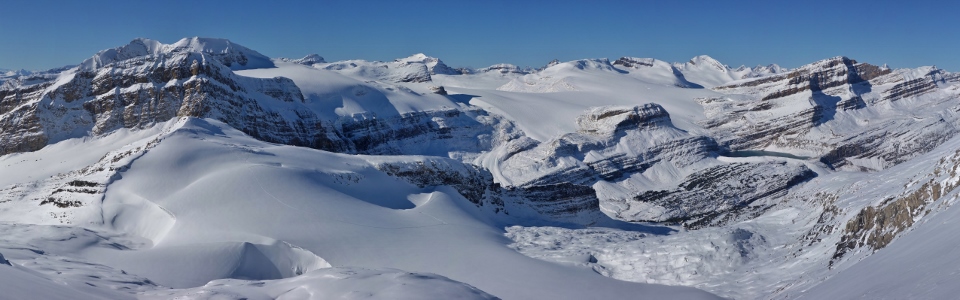
Despite the disappointment of aborting our attempt, the panorama of the Wapta Icefields to the west was an incredible consolation prize. This may well have been the most spectacular day that I’ve ever had in the mountains; bittersweet that it didn’t end with a summit but would the views 125 meters higher have been much better? Click to see larger.
.jpg)
Mount Balfour (left) and the Vice President and President (right) highlight the view over the Waputik Icefield towards Yoho National Park.
.jpg)
Mount Olive (left) and Mount Gordon (center) rise above Vulture Peak. The peak on the distant right is likely Mount Des Poilus.
.jpg)
Land of ice and snow.
.jpg)
Iceberg Lake’s deep blue waters contrast its snowy surroundings – a small pool of flowing water amidst a frozen landscape.
.jpg)
Even without a summit, it’s hard not to smile on a day like this (plus everyone else was stuck at work)!
.jpg)
Phil makes his way back from the scenic whence we came.
.jpg)
Admiring our glacier-scoured surroundings on descent (much of this terrain was shaded during our early morning ascent).
.jpg)
Summer’s wet slabs become winters hidden sheets of ice!
.jpg)
Mind your step…
.jpg)
Re-joining the previous day’s skier’s skin track as we make our way back across the “natural waterslide.”
.jpg)
I’m not certain that the skier took the most pleasant way through the trees but we were through with breaking trail at this point!
.jpg)
Phil tiptoes back across the chockstone before making, what could only be described as, a “graceful” descent (quotation marks employed to suggest otherwise).
.jpg)
About 4.5 hours after we abandoned our summit bid high on Crowfoot Mountain, we finally got back to the trailhead on Bow Lake’s colorful east shore. Exhausted from the day’s effort, we vowed not to return (until at least next year).
.jpg)
As we drove home, we pulled off the highway at the Crowfoot Glacier viewpoint to assess our day’s toil. So close, yet so far away…
…it might not have been the summit view that I was seeking but the view from the ridge crest was outstanding, and a day off work under clear skies in the mountains with good company was – well – “splendid.” :-)
.jpg)
.jpg)
.jpg)
.jpg)