Before I became a dad, I had no idea how difficult it would be to hike with a baby. During Mera’s many hikes this summer, there are moments where I wonder: “Why did I think this was a good idea?” Despite the inevitable challenges, hiking with our baby girl is also extremely rewarding and, in an age of technology and urbanization, Brianne and I want her to grow up with a love and appreciation of the wild. So we keep at it and tote our little girl about the magnificent Rockies; sometimes she screams bloody murder and sometimes she cackles with glee as the mountain-top breeze tickles her skin. Like many aspects of parenthood, there are highs and lows when you’re hiking with a baby. Every day has its good, its bad and its ugly! Case in point: Mount Lipsett…
Mount Lipsett is located to the west of Mist Mountain’s dramatic ramparts amidst the beautiful scenery of Kananaskis’ Highwood Pass. For several years, the peak has been on my list of shoulder season targets. With a well-graded coal exploration road leading nearly to its summit and the larches in the area turning their characteristic amber color, I, therefore, suggested that it might make for a good family outing. When Aurore asked what sort of “suffering” we were up to for the weekend, we invited her along as well, granting us a long overdue chance to catch up.
.jpg)
The whole family’s ready to go hiking! Hooray!
.jpg)
The trailhead for Mount Lipsett can be found at an obvious gravel pullout 4.4 km west of the Mist Creek day use area on Highway 40. Numerous other hikes (Mist Mountain, Mist Ridge, Mist Mountain Hot Springs) depart from this same trailhead; fortunately, there’s ample parking available!
.jpg)
A key junction is reached a few minutes beyond the trailhead. Steer climber’s left for Mount Lipsett and take the cairned right-hand branch for Mist Mountain, Mist Ridge and the Mist Mountain Hot Springs. It pays to make sure that you follow the right trail (just ask the family that we ran into looking for hot springs near Mount Lipsett’s summit…)!
.jpg)
Happy hikers ascend the well-graded decommissioned road through dense forest.
.jpg)
Fresh evidence of ursine trial use; this dropping was not left behind by a small animal… “Yo Bear!”
.jpg)
Although the forest obscures the views for the first several kilometers, occasional clearings hinted at the expansive larch forests nearby.
.jpg)
Happy hiking Hobbs’. File this part of the day under “good!” (Photo courtesy Aurore)
.jpg)
Hills topped with golden larches give way to the larger peaks of the Elk Range beyond.
.jpg)
Crux looks very interested in Aurore’s peperoni. Fortunately, the salty snack attracted mountain dogs and not bears!
.jpg)
Mist Mountain appears beyond the larches as we leave the exploration road’s switchbacks behind upon gaining Mount Lipsett’s southeast ridge.
.jpg)
The views finally open up as the old road leaves the forest behind. Click to see larger.
.jpg)
The summit of Mount Lipsett (distant snowy bump in the center) is dwarfed by nearby Mist Mountain. The old road continues across the false summit’s slope to the left but a good trail continues straight to the summit in the center of the photo. Click to see larger.
.jpg)
Spectacular fall colors up high.
.jpg)
Crux and the girls enjoy spectacular larch-filled vistas as the trail contours around the southeast (lee) side of a false summit. As you can see from the smiles, everything’s good!
.jpg)
The summit push. I may be going uphill here but the day out with the baby, unfortunately, is starting to go downhill. As we neared the top, the wind picked up and so did the wailing from the baby on my back. Although the trail veered to the windward (left) side of the slope, I tried (in vain) to keep Mera happy by ascending terrain on the lee side. (Photo courtesy Aurore)
.jpg)
Aurore perfectly captures the “Was this worth it?” moment of the hike as Mera cries and a snowstorm approaches on the 2576 m high summit of Mount Lipsett. Unfortunately, this part of the day will be filed under “bad.”
.jpg)
Brianne tries to calm/warm Mera and Crux tries to charm his way into another peperoni treat while a summit snow squall passes over.
.jpg)
Like a metaphor for the ups and downs of hiking with a baby, the squall passes and sunny blue skies reveal a spectacular view! Click to see larger.
.jpg)
Crux enjoys the up-close view of Mist Mountain. The scramble route up Mist ascends the face directly behind Crux but a less technical “hiking” route also exists on the backside.
.jpg)
Looking east towards the Highwood Range. Mount Head and Holy Cross Mountain are visible on the center left while Mount Burke can be seen along the horizon on the center right.
.jpg)
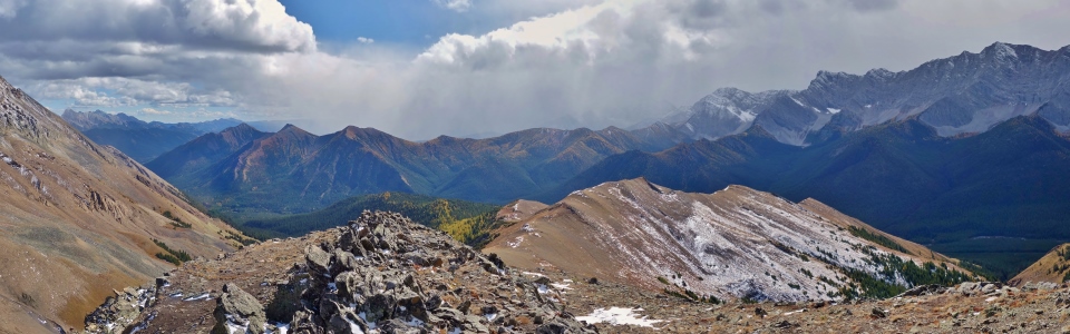
The spectacular panorama to the south follows the rocky continental divide as the Elk Range (right) gives way to the more southerly High Rock Range (center). From left to right: unnamed (distant), Mount Head (distant), Holy Cross Mount (distant), Mount Burke (distant), larch-covered Odlum Ridge, Mount Maclaren, Mount Muir, Mount Bishop, Mount Loomis, Mount Odlum and an outlier of Mount Storelk. Click to see larger.
.jpg)
A closer look at nearby Odlum Ridge, aflame in amber larches.
.jpg)
Mount Storelk’s east face presents a sheer wall to the west. It’s hard to believe that there’s a scrambling route up this face!
.jpg)
Looking north as Highway 40 winds its way up Highwood Pass (the highest point accessible by paved highway in Canada). From left to right: Mount Storelk, Mount Tyrwhitt, Mount Pocaterra, Highwood Ridge, Gap Mountain, Elpoca Mountain and Storm Mountain. Click to see larger.
.jpg)
Storm Mountain presents dramatically folded rock strata to the north.
.jpg)
There’s my happy mountain girl! After a heartbreaking summit cry, Mera perked back up when we put her down and left her free to explore her alpine surroundings. Looks like our rollercoaster baby outing is trending back towards “good”!
.jpg)
Staying warm on a chilly summit thanks to Aurore’s stylish mittens.
.jpg)
Daddy – Daughter playtime atop Mount Lipsett. (Photo courtesy Aurore)
.jpg)
Brianne enjoys a summit sandwich while Crux models the latest in canine fashion (gotta keep those soft ears warm)!
.jpg)
Just when things were looking “good” and we thought that the day had been salvaged, along came THE UGLY: a fierce blizzard (much stronger than the earlier snow squall we endured) developed much faster than anticipated and sent us fleeing from the now-frigid summit!
.jpg)
At least someone had a wind/water-proof refuge from the elements!
.jpg)
Hiking down in a winter wonderland. (Photo courtesy Aurore)
.jpg)
More ugly – the cold, wet weather made for a sloppy trail in places. This photo was taken only moments before Brianne took a nosedive into a mud puddle.
.jpg)
Luckily the skies cleared as we got back down the parking lot! :-P
.jpg)
Cold, wet and with a face-full of mud…but still smiling! With all of the day’s highs and lows, its good, its bad and its ugly, it’s still great to get out to the mountains as a family! Hiking with a baby isn’t always easy but it’s always worth it!
.jpg)
.jpg)
.jpg)
.jpg)
.jpg)