Over a year removed from our last vacation (thanks COVID) and 6 months removed from our last weekend getaway, April 2021 saw Brianne and I burning out. Between our kids, my job and Brianne’s 4 (!) jobs, the daily grind very much felt that way. All work and no play, as they say… When the Weather Gods presented us with the gift of a rare week of stable, clear and warm conditions, we therefore seized the opportunity for a “respite.” Cancelling our Friday shifts and arranging for childcare, we set our eyes west towards the still-snowy Rockies for some much-needed mountain therapy 🏔️.
Hoping to avoid a return to winter, Brianne agreed to put up with a longer drive than she’d usually tolerate (she’s worse than our kids on car rides 🤯)! Fortunately, I had the foresight to provide her with an early birthday present (a new Fitbit) to keep her occupied during the commute. As she obsessively monitored her heartrate, we sped south towards the Crowsnest Pass where we hoped to find spring hiking conditions to match the wonderful, warm weather. To maximize our chances of avoiding a snowy slog, we decided to attempt Livingstone South Peak since its ascent slopes are open and south-facing. After a mid-drive Google search suggested that April is migration season for golden eagles, we decided to tack Piitaistakis (“Place of the Eagles”) onto our agenda since it was part of Livingstone’s south ridge anyways. Afterall, nothing says “R&R” like a multi-peak day!
After driving past Frank Slide, we took the exit for the Interpretive Center and left the main road at an obvious hairpin. Following a dirt road for 1.6 km, we reached an intersection with a grassy parking area on its north end. After briefly parking there, we decided to complicate our lives by driving further. This is a solid strategy provided that you’re on the right road (the one that trends northeast). Unfortunately, we weren’t. For anyone planning to ascend Livingstone South, I’d recommend a bit more Google Maps recon than I did ahead of time. Those who do not learn from Matt’s trip reports are doomed to repeat them! 🤣
While the road that we followed continued to gain elevation, it took us further south than we wanted to be. As we’d driven past the intersection, I grew more and more certain that we were on the wrong road but admitting a navigational error in front of one’s wife is a precedent that I refuse to set! Doubling down on my error, we parked where the road got rough and continued hiking up it on foot. I knew we were further south than intended but figured that just put us in a better position to start our day by hiking up Piitaistakis (since it sits at the southern extreme of the Livingstone Range). 🤷♂️
.jpg)
Brianne merrily follows the (wrong) road on a sunny spring morning. Piitaistakis is just out of sight to the right of the grassy hill ahead.
.jpg)
.jpg)
LEFT: After following the (wrong) road through a clearing, we were presented with the choice of post-holing up a still-snowy gully in the shade or side-hilling through the sunnier aspen forest. Since bushwhacking is a requirement for any good Matt Hobbs adventure, we opted to stay in the sun.
RIGHT: After our warmup thrash, we eventually found a trail which brought us to more open slopes.
.jpg)
Brianne ascends open hillside, aiming towards an abandoned mine of some sort.
.jpg)
A definitive sign that spring is finally here! Purple pasque flowers (ie: prairie crocus).
.jpg)
.jpg)
LEFT: Some “pretty little yellow flowers” (!) that delighted yours truly more than they should have. 🌻
RIGHT: A colorful view towards Turtle Mountain and Frank Slide from the abandoned mine.
.jpg)
Above the mine works, we continued to trend towards the climber’s right where we gained the treed ridge crest just below Piitaistakis.
.jpg)
Porcupine Hills and prairies are revealed to the east beyond Piitaistakis’ dwindling cornice.
.jpg)
Surrounded by beautiful views, Brianne squints to see if she’s reached her 10,000 step goal yet. 🤦♂️
.jpg)
The town of Bellevue occupies the valley below Piitaistakis as the Rockies stretch south towards the US border.
.jpg)
Chief Mountain (left), Prairie Bluff (center) and Victoria Peak (right) highlight the view to the southeast.
.jpg)
Castle Peak is readily apparent to the south beyond Mount Gladstone (center left) and Table Mountain (center right).
.jpg)
What’s left of Turtle Mountain and the former site of Frank, AB.
.jpg)
To the west, the Flathead Range rises up beyond Blairmore. From left to right: Andy Good Peak, Mount Parrish, Mount McLaren, Chinook Peak, Ostracized Peak and Sentry Mountain.
.jpg)
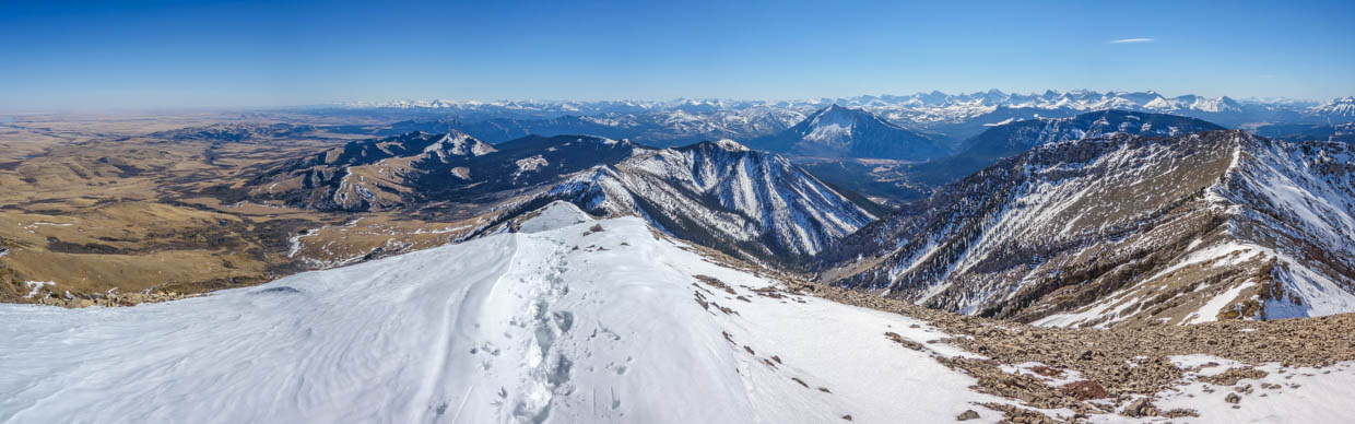
Looking north along the spine of the Livingstone Range: the easternmost buttress of the Rockies in this area. The prominent peak at center is Livingstone South (our ultimate goal for the day). When I pointed it out to Brianne, I was sure to mention that it’s probably not as far as it looks… Click to see larger.
.jpg)
Mount Morin (left), Livingstone South (right) and the undulating ridge we’d follow over the course of the following hours. The fact that I needed a telephoto to show our next summit may be indicative of its actual distance from us at this point… 🤔
.jpg)
Summit selfie #1 – “I’m sure that pointy peak in the background isn’t as far as it looks, Hon!”
.jpg)
Suspicious that I was sandbagging the distance to Livingstone South and, with nary an eagle in the sky, Brianne didn’t linger atop Piitaistakis and started north towards our primary target. After a few minutes of photography, I joined her.
.jpg)
As always in the Southern Rockies, dead trees proved surprisingly scenic.
.jpg)
A brief stop at the local Space Command Center along the way…
.jpg)
What goes up Piitaistakis must go down…and then back up…and then back down…and then back up…
.jpg)
.jpg)
LEFT: Passing underneath a powerline right of way.
RIGHT: More dead trees! 🤪
.jpg)
After passing the power lines, we found a scenic place to stop for first lunch. The clearing below is the road that we probably should have driven up…
.jpg)
After a hearty respite, we set back off. Onwards and upwards (again)!
.jpg)
A rare site in this area: a live tree in the alpine! Note, however, this this pine is unusually supine. While vegetation provided ample evidence that this ridge is frequently ravaged by extreme winds, we were lucky; on this day, there was only a very slight upslope breeze!
.jpg)
.jpg)
LEFT: The Seven Sisters come into view beyond a series of outcrops on the ridge.
RIGHT: What a strange-looking eagle! 🤣 As we continued north towards our peak, we stumbled upon a group of parasailers who were taking advantage of the same updrafts that the eagles (supposedly) do to soar effortlessly above.
.jpg)
As temperatures neared 20 C and the summit finally looked close, Brianne was all smiles! Note, however, that the ridge in the foreground is beginning to look a little more interesting…
.jpg)
.jpg)
LEFT: The Oldman Reservoir makes an appearance through a notch in the, suddenly interesting, ridge.
RIGHT: As we followed the ridge, we suddenly reached a significant downclimb. Backtracking to the notch, we carefully descended its snowy east face to bypass the drop-off on the ridge crest.
.jpg)
Shortly after descending from the notch, the ridge crest, once again, sharpened. In dry conditions, I believe that this bit of moderate scrambling can be bypassed on steep grass to the right (east). Today, however, those slopes held snow and a slip on them seemed likely to send us straight down to the prairies below. After scouting the ridge crest and deciding that we didn’t care for the significant drop to its left or slip-and-slide to its right, we decided to by-pass by scrambling all the way down to the trees on the left. The terrain that we covered was steep, loose and unpleasant. As a result, I was not a popular husband for the 20 minutes that followed… 😬
.jpg)
Brianne curses at me (although by this point, we were well passed the worst of our by-pass).
.jpg)
.jpg)
LEFT: With the difficulties of the by-pass/ridge behind us, Brianne tackled the final slope towards Livingstone South’s pyramidal summit. This ridge offered delightful hiking but the foreshortened view and never-ending false summits conspired to make us somewhat weary. At least, Brianne would have no problem meeting her 10,000 step goal today!
RIGHT: Crowsnest Mountain and the Seven Sisters made a scenic appears through the Livingstone South – Mount Morin col as we finally neared the summit.
.jpg)
.jpg)
LEFT: At long last, 5-hours after leaving the car, we reached the summit of Livingstone South. Turns out this peak is exactly as far as it looks from Piitaistakis!
RIGHT: A damned tragedy. When we stopped to fill up with gas in the morning, Brianne grabbed some chocolate for a summit treat. All day long, we’d fantasized about enjoying it as the center piece of our second lunch. Turns out that Reese’s Peanut Butter Cups do not travel well in 20 C heat… Undeterred by the candy’s fecal appearance and texture, however, we ravenously smeared it across our faces in an absurd attempt to extract its precious calories.
.jpg)
After making a complete mess of ourselves, we paused to focus on the positive: Livingstone South’s pleasant, prairie-filled summit panorama. Click to see larger.
.jpg)
To the north, the Livingstone Range continues, culminating in its highest point (Center Peak) some 7.5 km away.
.jpg)
Flatlands and foothills to the east.
.jpg)
The Oldman Reservoir, surrounded by windfarms.
.jpg)
The panorama south from whence we came. Notice how far away Turtle Mountain looks relative to earlier in the day?... Click to see larger.
.jpg)
Chief Mountain, Prairie Bluff and Victoria Peak are still apparent to the south beyond tiny Tallon and Robertson Peaks. From Livingstone South’s higher vantage, the tallest peak in Glacier National Park, Mount Cleveland, is also apparent (center right).
.jpg)
Piitaistakis (center left) sure looks far from up here! The more proximate high point at center right also has an unofficial name (“the Dog”) and we briefly contemplated visiting it to add a 3rd summit to our day. Then, sense prevailed.
.jpg)
Looking south into the heart of Castle Wildland Provincial park. Mount Haig is the obvious peak at center, rising up over Gravenstafel Ridge and the Castle Mountain Ski Resort.
.jpg)
Hillcrest Mountain (center left) and Turtle Mountain (center right).
.jpg)
Nearby Mount Morin fills the westward panorama towards the Crowsnest Pass and the Alberta-BC border. Click to see larger.
.jpg)
Mounts Darrah (left) and Ptolemy SE5 (right) are obvious Flathead Range high points to the southwest.
.jpg)
A flurry of Flathead peaks. From left to right: Mount Pengelly, Mount Mcgladrey, Ptolemy SE5, Mount Coulthard, Mount Ptolemy and Mount Parrish. Those with eagle eyes may also spot Willoughby Ridge (and the Ironstone Fire Lookout) atop it in the middle-ground below Ptolemy SE5.
.jpg)
Ostracized Peak/Sentry Mountain (left) and Phillipps Peak/Mount Tecumseh booked the Crowsnest Pass. Distant BC highpoints beyond the pass include: the Three Sisters, Mount Bisaro and Mount Fisher.
.jpg)
The High Rock Range (right) rises up to the northwest of the Flathead Range (left). Click to see larger.
.jpg)
The area’s iconic peak: Crowsnest Mountain and its scenic neighbor, the Seven Sisters. Mounts Washburn and Fryan are also visible in the distance.
.jpg)
Grassy Mountain (foreground) was, until recently, set to be exported piece-by-piece to Australia. Beyond Grassy, McGillivray Ridge rises up. Racehorse Peak (center left) is obvious beyond McGillivray. Most distant still and, at center, the southernmost of the Rockies’ 11,000ers, Mount Harrison, can also be seen.
.jpg)
Gould Dome (center left) and Tornado Mountain (center) are spectacular peaks in the heart of the High Rock Range.
.jpg)
Summit selfie #2! Taken 3.5 hours after our first atop Piitaistakis. I guess Livingstone South was exactly as far away as it looked from there!
.jpg)
After a sunny, 20 minute stay atop Livingstone South, it was time to start our long hike back. Fully aware that it had taken us 3.5 hours to traverse from Piitaistakis, we resisted the urge to linger for fear that the Pass Brewing Company in Blairmore would be closed by the time that we got down! Pity we forgot our parasails!
.jpg)
Brianne descends Livingstone South’s delightful ridge (it certainly felt more delightful going down it than up)!
.jpg)
On our return trip, we opted to stay atop the narrow ridge crest and saved at least 20 minutes time by not repeating our awful by-pass of it. Unfortunately, this photo doesn’t convey how steep the snow to the left was or how sheer the drop to the right was. Suffice to say that it was spicy enough for me… 🌶️
.jpg)
.jpg)
LEFT: Brianne by-passes the spiciest section of the ridge. I contemplated following her but learned my lesson earlier and just gutted it out on the ridge crest this time.
RIGHT: Kicking steps back up the, now icy, snow towards the notch.
.jpg)
After ascending to the notch, we were on “Easy Street” and a mindless, one-foot-in-front-of-the-other descent over scenic, rolling terrain ensued.
.jpg)
Pulling the pin early! After tiring of the ridge’s many ups and downs, we decided to abandon it and descended a service road near the power lines. Had we driven up the correct road in the morning, our car would be directly below at this point…
.jpg)
Since we chose poorly on the area’s labyrinth of roads earlier, however, we were forced to hike down the (correct) road. As we jogged towards Turtle Mountain, we hoped against hope that this road would connect to the one that our car was parked alongside!
.jpg)
.jpg)
LEFT: Guess we weren’t alone on the road… 🐻
RIGHT: Mercifully, we connected with the road that we’d parked alongside without a great deal of undue wandering. Unfortunately, that elevation that we’d gained in our car earlier, now had to be regained on foot. Since I am, above all else, a gentleman husband-in-trouble, I offered to jog up the road to collect our car. Brianne might even have been tempted to take me up on that offer had it not been for the footprint we’d just seen on the road! Instead, we commiserated as we finished a beautiful day by hiking up an ugly road!
.jpg)
Hallelujah! After 7.5-hours, 34,479 steps, 4,068 calories, 56,364 heart beats and the equivalent of 412 flights of stairs each, we found ourselves back at our ill-advised starting point. Turns out that Livingstone South Peak was exactly as far away as it looked earlier this morning!
.jpg)
Thanks to a speedy descent (2.5 hours from summit to car), we made it to the Pass Brewing Company before closing time. As you can see, we managed to undo every last calorie that we’d burnt on their spacious, sunny patio!
.jpg)
Drinking a few extra calories for good measure! Afterall, rehydration is key following a long, sunny day of much-needed multi-peak mountain therapy! 🍻
.jpg)
.jpg)
.jpg)
.jpg)
.jpg)