Not too long ago, I devoted countless hours to planning ascents of infrequently visited peaks. In recent years, however, my focus has shifted towards looking for new family-friendly “mountains” to hike up with my girls. Surprisingly, finding tot-suitable peaks has proven every bit as challenging as plotting new routes up remote mountains! Sometimes my plans work out perfectly and sometimes I wear the “goat horns.”
With a busy 3-year-old and a busy 1-year-old, I’ve come to realize that fire lookouts make for great objectives since they offer panoramic mountain views and usually involve hiking up easy roads. The latter are ideal for little hikers whose balance remains a work-in-progress while the former tends to keep Daddy happy. When I stumbled across Matt Clay’s Ironstone Lookout trip report, I quickly short-listed it. I’ve not visited Crowsnest Pass often and I reasoned that Ironstone would provide a good excuse to return with my family in-tow. In terms of distance and elevation stats, it certainly seemed toddler-appropriate.
My wife, however, was less-than-enthusiastic at the prospect of a 2.5-hour drive (each way) with our howler monkeys confined to their carseats. When the forecast promised rain all over the Rockies except Crowsnest Pass, however, I sensed a moment of weakness in her anti-long-drive resolve. Pouncing on that weakness like a puma on unsuspecting prey, I pointed out that the girls had been very good on recent long drives and assured her that they would almost certainly sleep most of the way anyhow…
Of course, that mere suggestion condemned us to a drive of constant screaming and bickering in addition to several false-alarm potty stops. Even though both girls had stayed up well past their bedtime the night prior (Go Stamps Go!), neither opted to take advantage of the much-needed opportunity they were being given to catch up on rest (until we were moments from the trailhead that is). Suffice to say that our drive down to Crowsnest Pass did not proceed as smoothly as hoped. As my friend Onge would say: “KIDS…”
.jpg)
During my usual pre-trip research, I came to the conclusion that I wasn’t concerned about the hike up Willoughby Ridge but I did have some concerns relating to the drive to reach its “trailhead.” From Coleman, this drive is only vaguely described in most online trip reports and the York Creek access road is conspicuously absent on Google Maps. Of course, I kept these details to myself when I was selling my wife on Willoughby. I assumed that we’d figure it out when we got there (and with the exception of 3 wrong turns, I was correct). In the interest of saving others from bottoming out their vehicles more often than is required, however, I’ll start this TR with a few photos of key “intersections.” Shown above is the corner of 81st Street and 13th Avenue in bustling Coleman, AB. This is where the York Creek Road begins (innocently enough) by heading uphill to the west before turning south.
.jpg)
After a few kilometers, the road passes a signed “Staging Area” with ample parking. Continue straight here and ignore the temptation to take any side-roads with obvious “No Trespassing” signs (just like we did, I swear…).
.jpg)
Beyond the staging area, the road gets rougher but remains within the realm of “reasonable.” After a few minutes, you’ll reach a fork where we stayed left and crossed York Creek on the bridge in the photo above. I believe that the road to the right leads towards Mount McLaren.
.jpg)
Beyond the bridge, the road began to switchback up steep hillsides. At the intersection shown, stay right and continue on, what appears to be, a smaller road. This smaller road side-hills across a relatively open slope. We mistakenly followed the larger main road up a few extra switchbacks. Eventually, we realized that we were trending in the wrong direction and back-tracked to correct course.
.jpg)
Stay left at this intersection and continue to follow the road up. Beyond this point, the road was reasonably rough and a high clearance vehicle is definitely required.
.jpg)
Our parking spot for the day. After mistakenly following the right-hand fork thanks to a misleading rock spray painted with an arrow, we were forced to make an awkward 28-point-turn before retreating. The left-hand fork is the actual fire lookout access road which made this a good place to park. Although some ATVers apparently ride all the way up to the lookout, I’d recommend parking here and enjoying the 4.5 km hike to the top! By the time that we reached this spot, we were more-than-ready to be out of the car anyways!
.jpg)
An access gate moments from where we parked. This gate provided some welcome confirmation that we were hiking up the right road at least! (Would it kill someone in the Crowsnest Pass to put up some signs for hikers?)
.jpg)
Happy to be out of the car and hiking at last! Of course, this only lasted for 2 – 3 minutes after which time Mera informed us that she was tired. Perhaps if someone had slept during the 3-hour-long drive… 🤦♂️
.jpg)
The road contours along Willoughby’s west aspect. Thanks to recent forestry, we were able to see the summit ahead after hiking for a mere 1 km.
.jpg)
Recent clear-cutting also granted fine views of nearby Mount Coulthard beyond a carpet of yellow wildflowers which have taken advantage of the newly open slopes.
.jpg)
About 1.5 km from the “trailhead”, the road switchbacks sharply back to the north. At toddler-speed it took us about an hour to reach this point and, when we did, it was time to stop for a snack (despite the fact that our girls already ate at least one day’s worth of food on the drive)!
.jpg)
At least the views from our snack-stop were good! Click to see larger.
.jpg)
Two of the many yellow wildflowers that littered the freshly forested slopes (Matt Clay would know what they are).
.jpg)
Happy snackers!
.jpg)
On the road again. As we continued to switchback upwards, the flora became less yellow and more violet/pink.
.jpg)
Some of the aforementioned violet wildflowers (Matt Clay would know what they are).
.jpg)
And not to be outdone, the pink flowers (Matt Clay would know what they are).
.jpg)
A remarkably colorful dead tree provides a sharp contrast to the remainder of the forest (I, at least, know what that plant is).
.jpg)
About 2.5 km from the car, the road rounded a bend which granted views of Willoughby’s grassy north summit. The road actually bypasses this sub-summit entirely and continues below it on Willoughby’s west aspect.
.jpg)
Our “Baby Bear” very pleased to let Daddy take care of this hiking business. When we set out, we figured that she’d be weary from the long drive and started off with her on-foot. Within minutes, however, she was pointing up at my backpack and grunting to make us aware of her wishes.
.jpg)
Sentry Peak (left) and Phillips Peak/Mount Tecumseh (right) make an appearance to the northwest from one of the hike’s many opening. Between the peaks, Crowsnest Ridge (middleground) and much-larger Mount Washburn (background) are also visible.
.jpg)
Mom and Mera stop to take in one of the many wonderful views towards the nearby Flathead Range.
.jpg)
As the road crested the saddle between Willoughby’s north and south summits, we were blasted by the typically intense Crowsnest Pass winds. Around this point, Mera’s lack of sleep also began to catch up with her and, rather than pushing our luck, we gave her the option of continuing on Mom’s back.
.jpg)
Pleasant views beyond wildflower-covered slopes at the col towards Turtle Mountain's still intact west face. Its east face, of course, looks much different!
.jpg)
From the col, the lookout and summit come into view to the south.
.jpg)
Mera enjoys the constantly improving scenery from her perch on Mom’s back. Funny that Brianne’s never offered to carry me up the final stretch of a mountain this way!
.jpg)
Ironically, Willoughby Ridge was scorched by the Lost Creek Fire in 2003 (despite it having a fire lookout on its summit).
.jpg)
Mera tackles the summit push on her own as the Ironstone lookout building comes into view.
.jpg)
With the aim of respecting the lookout’s privacy, we bypassed the summit proper and aimed for the nearby, makeshift helicopter pad.
.jpg)
Penny enjoys a sandwich while using Daddy’s In-Reach to send our customary summit message to our families.
.jpg)
The panorama to the north and east is dominated by nearby Crowsnest Mountain (left) and Turtle Mountain (right). Click to see larger.
.jpg)
Deadman’s Pass Peak, Allison Peak, Window Mountain, Mount Ward and Racehorse Peak are visible to the left of Crowsnest Mountain while Tornado Mountain is prominent to its right.
.jpg)
A closer look at the region’s namesake peak: Crowsnest Mountain.
.jpg)
Ma Butte (left) and McGillivray Ridge (right) are also obvious beyond Willoughby’s more proximate north peak.
.jpg)
The Livingstone Range (left) and Turtle Mountain (right) highlight the panorama to the northeast. Click to see larger.
.jpg)
The girls enjoy their third lunch of the day while Mera’s hair provides an indication as to the direction of the prevailing wind!
.jpg)
Hillcrest Mountain rises up to the east beyond a wildly whipping wind sock. Apparently, the wind was gusting up to 80 km/h while we were on the summit. Hardly atypical in this area but not entirely pleasant either!
.jpg)
Penny enjoys her summit sandwich despite the constant barrage of westerly wind.
.jpg)
After enduring the strong winds for about 10 minutes, the fire lookout and his wife invited us to join them in their lookout’s lee. As you can see from the girls’ faces, this respite from the wind was most-welcome!
.jpg)
A vibrant and verdant panorama south from the lookout’s porch. Click to see larger.
.jpg)
Mera enjoys a perch on the lookout’s porch. Sadly, our front porch doesn’t sport views anything like this…
.jpg)
The windfarms on the prairies to the east were, no doubt, quite productive today!
.jpg)
The combination of forestry and fire have created an almost impossibly green valley southeast of Willoughby.
.jpg)
Peaks of the Castle Wilderness make an appearance to the southeast. Notable amongst them: Prairie Bluff (left), Victoria Peak (center), Table Mountain (center right), aptly-named Castle Mountain (center righter) and Whistler Mountain (right).
.jpg)
Looking deeper into the heart of the Castle Wilderness. From left to right: Castle Mountain, Whistler Mountain, Lys Ridge, Southfork Mountain, Barnaby Ridge, Syncline Mountain, St. Eloi Mountain and Mount McCarty.
.jpg)
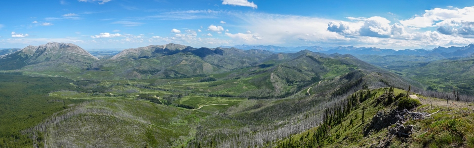
The panorama of the nearby Flathead Range was really the highlight of the day! Click to see larger.
.jpg)
Mount Darrah (center left) rises up beyond an unknown summit contraption (are the lookouts beekeepers?). The prominent peak on the center right is actually an unnamed outlier of Mount Ptolemy.
.jpg)
Mount Coulthard is obvious to the right while three, surprisingly unnamed, peaks rise of to its south (left).
.jpg)
While none of the peaks immediately to Coulthard’s south are named, all of the peaks to its north are! From left to right: Mount Coulthard, Andy Good Peak, Mount Parrish, Chinook Peak and Mount McLaren.
.jpg)
After enjoying the rest of our lunch in the lookout’s lee, we asked the kind occupants to take a family photo for us before packing up and bidding them adieu. Should they ever read this blog, many thanks for the hospitality (and the wonderful family photo that features surprisingly cooperative children)!
.jpg)
Enjoying the views towards Crowsnest Mountain (thanks to the Lost Creek Fire) as we begin our descent.
.jpg)
Another great view towards shapely Mount Coulthard on descent.
.jpg)
Views of Mount Tecumseh beyond fields of yellow keep us moving. With a child on each of our backs, Brianne and labored downwards with screaming shoulders and aching feet. The 4.5 km hike up felt short but the hike back down (as is so often the case) felt anything but!
.jpg)
Final views towards Crowsnest Mountain as the “trailhead” gate finally (and mercifully) comes back into view.
.jpg)
“Special” drinks back at the car! After a toasty descent, the girls enjoyed sharing a chilled strawberry-kiwi juice while Mom and Dad enjoyed a selection of significantly more refreshing beverages!
.jpg)
That juice really hit her hard!
Within instants of starting back down the rough road, Mera and Penny both passed out (despite the many bumps bouncing them around like bobble-heads). Sadly, the “peaceful angel” part of our drive home was short-lived. Within 45 minutes, they were both back awake and screaming (again). While the drives to and from Wiloughby proved borderline disastrous, everyone seemed to thoroughly enjoy the hike at least! Still, I think I’ll resist the urge to suggest another long drive for a couple of weeks until the events of July 14 fade from memory (especially Brianne’s)! KIDS…
At least we dodged the rain! 🤣
.jpg)
.jpg)
.jpg)
.jpg)
.jpg)