After a thoroughly enjoyable (and extremely overdue) kid-free scramble date with my wife in April, we vowed to make more time for ourselves going forward. With 5 jobs between us, 2 young kids to care for and a global pandemic in progress, spare time is at a premium and it can be easy to forget the things that matter most in a marriage: MOUNTAINS. 🏔️
But, if something is important, you MAKE time for it. So, with clear, warm weather forecast for June 1, Brianne and I both took “staycation” days from work(s) and arranged childcare for our wee ones. Free from our usual responsibilities, we set our sights south, hoping to find a peak that was similarly free from snow and lingering winter conditions. With mid-summer weather finally forecast, we were looking forward to hiking in shorts and t-shirts once more. Sun’s out 🌞; Guns out! 💪
.JPG)
.JPG)
LEFT: After enjoying a 2+ hour kid-free drive together, we reached the Crowsnest Pass area and proceeded to blow by our trailhead twice (once in each direction!). Fortunately, the third time proved to be the charm and we, eventually, found the correct roadside to park on under Sentry Mountain’s (nearly) snow-free east face.
RIGHT: After successfully disassembling and then reassembling a makeshift barbed wire gate, we followed a dirt road south towards Sentry.
.JPG)
About 1.3 km from the trailhead, we left the road to follow an obvious cut line. A quick glance at satellite imagery revealed that we could also have stayed on the road but the cut line was, effectively, a “shortcut” line that saved us about 0.5 km approach distance.
.JPG)
After 5 – 10 minutes, the cut line spat us back out onto the road which we followed west towards Sentry (which, remarkably, looked no closer than it had 35 minutes earlier). In no hurry, we ambled along the road and enjoyed the strong summer sun. 🌞
.JPG)
.JPG)
LEFT: Eventually, the road ended and we followed a crude trail up a steep, forested hillside.
RIGHT: After a steep, initial huff-and-puff, the terrain leveled and the trail continued to follow the spine of a broad, open rib which granted pleasant views towards Chinook Peak.
.JPG)
Brianne pauses on the broad rib to enjoy the wonderful view that had unfolded behind us.
.JPG)
Glacier lilies were just beginning to bloom as we neared the tree line.
.JPG)
.JPG)
LEFT: Pretty purple pasqueflower!
RIGHT: No Crowsnest Pass scramble is complete without a scenic “dead tree” photo. In fact, this dead tree proved so scenic that we decided to stop and enjoy the view (along with our lunch) here. This may also have been a result of the fact that the route ahead was beginning to look very, very steep…
.JPG)
.JPG)
LEFT: Following a hearty repast, we set forth along a crude path which ascended a steep gully towards the Sentry – Ostracized col. Others have ascended the broad rib to Brianne’s left in this photo but we saw no real advantage to doing so and stuck in the gully to save some distance.
RIGHT: As the grade reached TFS levels, Brianne paused frequently to glance at her Fitbit which confirmed the expected: her heart was, indeed, beating. 🙄
.JPG)
Up, up we go. We continued up the foreshortened gully towards a snowy pinch point that cleaved 2 rock bands.
.JPG)
Near the “pinch point”, we spotted a large cave to the north which resulted in a small, exploratory diversion.
.JPG)
.JPG)
LEFT: Brianne enjoyed the slight sense of airiness as she navigated towards the cave. Goats live for ledges. 🐐
RIGHT: It seems that goats (or, more likely, sheep) also enjoy caves! Based on the proliferation of droppings at the cave’s entrance, this was clearly “somebody’s favorite spot."
.JPG)
While the summer sun sent temperatures soaring on Sentry’s slopes, the cave was, literally and figuratively, icy. Indeed, the sn’icy entrance prevented us from exploring any further for fear that a cornice obscured a, potentially, bottomless pit. I’m not sure how deep this cave went but its reverberant echo suggested that we might not want to find out…
.JPG)
.JPG)
LEFT: Brianne poses back outside in the land of the living. After a brief detour, we retraced our steps along the ledge and made our way back to the ascent gully.
RIGHT: Chinook Peak continues to impress across Sentry’s, still, snow-filled gully.
.JPG)
As the snow slopes overhead steepened dramatically, it became obvious that we would need to cross the snow gully to ascend more gentle grassy slopes to the south.
.JPG)
.JPG)
LEFT: As I crossed the still-icy gully, I heard my phone ring. Normally, I ignore that damned thing but, on this day, we were expecting a call from a bike shop RE: a sweet new ride for Brianne. Not wanting to miss out on a bike during a pandemic-fueled shortage, I therefore answered in the middle of a no-slip-zone.
RIGHT: Success! Not only did I manage to talk on the phone whilst remaining adhered to the mountain but, better still, we scored a new bike for Brianne! Someone’s ready to ride! 🚴
.JPG)
.JPG)
LEFT: After the bike-related excitement, we cruised up the steep grass slopes to the Sentry-Ostracized col before continuing north along the scenic summit ridge.
RIGHT: Brianne easily scrambles along Sentry’s south ridge towards its nearby summit.
.JPG)
Pleasant views west into nearby BC from the lichen-laden ridge.
.JPG)
Brianne smiles as she takes the final scenic steps up to Sentry’s scenic, sunny summit.
.JPG)
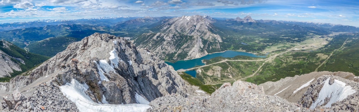
A SPECTACULAR summit panorama worth grinning ear-to-ear for! The Crowsnest Pass area isn’t one that usually comes to mind for top-tier Rockies scenery but Sentry Mountain’s unique positioning above Crowsnest Lake and just southwest of Crowsnest Mountain sets this peak apart from its nearby peers! Click to see larger.
.JPG)
Sun’s still out, as are the summit smiles! Date day success! 🌞
.JPG)
A closer look at Sentry Mountain’s premier summit view: The Phillipps Peak/Mount Tecumseh massif rises up above Crowsnest Lake’s deep blue waters while the area’s namesake peak points skyward across verdant plains to the northeast.
.JPG)
Somehow Phillipps Peak (center left) and Mount Tecumseh (center) are considered distinct summits.
.JPG)
Looking north beyond Mount Tecumseh towards the peaks of the High Rock Range (including, from left to right, Allison Peak, distant Tornado Mountain, Mount Ward, Racehorse Peak, Deadman Pass Peak and Gould Dome).
.JPG)
Looking over 1,000 m down at Crowsnest Lake (which is prettier if you ignore the transportation infrastructure all around it 🚚).
.JPG)
The Crowsnest Pass’ main event double feature.
.JPG)
Seven Sisters Mountain.
.JPG)
Magnificent Crowsnest Mountain.
.JPG)
Looking east towards the villages, towns and hamlets of the Crowsnest Pass Municipality which dot the open east-west-trending valley. Click to see larger.
.JPG)
Ma Butte (left) and McGillivray Ridge (center).
.JPG)
The peaks of the Livingstone Range (Center/Cauldron/Livingstone South) and Bluff Mountain backdrop the town of Coleman, AB.
.JPG)
Turtle Mountain (or what’s left of it) guards the valley’s eastern entrance.
.JPG)
While the southward summit panorama lacked the blue lake and green valleys of the northward one, the scenic peaks of the Flathead Range compensated adequately. Click to see larger.
.JPG)
Looking southeast towards Mount McLaren. To McLaren’s left, Hillcrest Mountain is visible while Prairie Bluff is visible (nearly 50 km away) to its right.
.JPG)
Some rather dramatic north faces among the nearby Flatheads.
.JPG)
Chinook Peak.
.JPG)
An unnamed peak southeast of Mount Ptolemy (that deserves better than being called Ptolemy SE5).
.JPG)
.JPG)
LEFT: Nearby Ostracized Peak (so name by So Nakagawa because it also wasn’t good enough for an official name). We contemplated an attempt of Ostracized to add another summit to our day’s tally but the amount of snow cover on its exposed ascent ledges convinced us not to bother. Date days are only fun if you survive them!
RIGHT: Mount Ptolemy makes all the other peaks jealous because it is both named and badass.
.JPG)
The westward panorama into beautiful British Columbia. Click to see larger.
.JPG)
Nearby Tent Mountain bears the scars of one of the area’s most significant industries: mining.
.JPG)
A telephoto panorama towards significant peaks on the BC side of the border. Click to see larger.
.JPG)
Looking west, the Three Sisters (center left), Mount Bisaro (center right) and Mount Hosmer (right) tower over Fernie some 30 – 35 km away.
.JPG)
Despite its impressive stature, Mount Washburn is rarely ascended.
.JPG)
A host of much larger peaks, including Mount Mike (center left) and 11,000er Mount Harrison (center right) rise up beyond more proximate Mount Erickson.
.JPG)
Brianne soaks up the summit sun and scenery in equal measure. After a 35-minute break atop Sentry, we started our descent, eager to continue date day with pizza and beer on the just-reopened Pass Beer Company patio in the valley below. 🍕 🍺
.JPG)
.JPG)
LEFT and RIGHT: Brianne negotiates the summit ridge aiming for the grassy Sentry-Ostracized col.
.JPG)
Back at the col, we remembered “Sun’s Out! Guns Out!” was the theme of this TR and took a selfie to that end. Note, however, that the sun was no longer out (but look at THOSE guns)! 💪 🤣
.JPG)
.JPG)
LEFT: A backlit Brianne pauses to demonstrate that the grassy descent slope was, indeed, TFS…
RIGHT: … Mercifully, remnant snow in the gully provided a speedy alternative! According to Brianne’s Fitbit our “pace” was 78 minutes/km on the way up this slope and 13 minutes/km on the way down. 🤯 Glissade FTW!!!
.JPG)
.JPG)
LEFT: Back on the open rib after a speedy descent of Sentry’s east face, I got to admire 2 beauties as we hiked out: the “Breezy Goat” 🐐 and Crowsnest Mountain!
RIGHT: Brianne darts through, what she determined was, a “micro-forest” on descent. *Scratches head along with the rest of you*
.JPG)
What goes up this gross steep hill must go back down it. The approach road and its easier travel were, however, close at hand!
.JPG)
♫ On the Road Again… ♫
As we sauntered down the road, we laughed, chatted and excitedly pondered possible pizzas for dinner. With another amazing date day drawing to a close, a thought suddenly occurred to me: “What if it’s not the MOUNTAINS that matter most in a marriage? What if it’s the time that we get to spend together in them?”
Before breathing that thought aloud to my wife, however, I decided that this epiphany must have been the result of some sun-stroke-induced euphoria. 🌞 That’s what happens on “Sun’s Out! Guns Out”-kinda days… 😂
Obviously, it’s the mountains that matter most, right? 😉 🙃
.JPG)
.JPG)
.JPG)
.JPG)
.JPG)