Elevation: Anderson Peak - 2698 m, Lost Mountain 2509 - m
Elevation Gain: 1430 m (cumulative)
Anderson Peak is the third-highest mountain in Waterton Lakes National Park. When viewed from the Park’s popular Red Rock Canyon, Anderson’s spire-like summit features a black band of Purcell Sill, which resulted when magma was injected between sedimentary layers. Igneous rock like this is exceedingly rare in the Canadian Rockies. Anderson was officially named in 1882 for Captain Samuel Anderson who served as Chief Astronomer for the British Boundary Commission between 1872 – 1876. Located 1.5 km from Anderson’s summit, Lost Mountain is officially named despite featuring a mere 93 m prominence.
My Ascents:
June 22 2022
Trailhead: Red Rock Canyon GPS Track: Anderson Peak & Lost Mountain
When camping reservations for Waterton Lakes National Park opened in January, I excitedly booked a 5-night June family camping trip to coincide with Father’s Day. It was cold. It was winter. We’d all just had COVID 🤒😷. I needed something to look forward to and summer mountain plans proved to be just what the doctor ordered 😃 (no ivermectin here)!
Excited, I booked vacation time and sent a calendar invite to Brianne. When she pointed out that Mera would still be in school during 3 of the planned trip’s 5 days, however, I felt rather foolish. As June neared, we decided to downgrade the trip from 5 days to 3 so that Mera would only miss 1 day of school (thanks to COVID-related school closures and COVID itself, she’d already missed a lot of class in 2022).
The camping trip was very nice and I managed to drag my family on a couple of pleasant hikes before we returned 3 hours north to Calgary to send Mera back to school (since it wasn’t her summer vacation yet)! My vacation was, however, already approved (by my wife and my employer) way back in January. It seemed a shame not to spend it in Waterton as I’d planned… 🙃
Since I already had the time off and the forecast for Wednesday June 22 looked magnificent 🌞, I reached out to Matt Clay to see if he was interested in a mid-week scramble (knowing full well that Matt C. is ALWAYS interested in mid-week scrambles). After I failed to convince him to dodge the US Border Patrol with me, we quickly settled on Waterton’s third highest point: Anderson Peak (and nearby Lost Mountain) and carpooled 3 hours back down to Waterton (which I’d just left 35 hours earlier 🙄🤷).
LEFT: Arriving at Waterton’s Red Rock Canyon, we found the, typically, popular spot less crowded than usual at 9 am on a Wednesday. Fortunately, the argillite was no less red and the canyon was no less pretty for lack of other visitors!
RIGHT: Setting off downhill (away from the canyon), a bridged crossing of Bauerman Creek near the parking area provided our first good view towards target #1: Anderson Peak. This viewpoint also confirmed what we’d noticed on our long drive south: that Environment Canada’s “mainly sunny” forecast for the day looked to be completely out to lunch. 🌥️
LEFT: After crossing Bauerman Creek, we followed the official trail a short 1.2 km to Blakiston Falls. For anyone with limited time/energy in Waterton, this short little hike proved quite scenic!
RIGHT: The view of the falls from Parks Canada’s space-age (and bilingual) viewing platforms. The custom metalwork on the platforms was kind of cool but, also, an obvious misappropriation of funds that could be better-spent reopening facilities that were closed following 2017’s Kenow Wildfire (cough cough: the Crandell Mountain Campground).
Upstream of the falls, Matt C. continues up the Blakiston Valley trail alongside noisy Blakiston Creek. Many a “Yo Bear” 🐻 was uttered as we hiked but I’m not sure anyone/anything could hear them thanks to the roar of the water!
LEFT: While the overcast conditions proved disappointing, the plethora of bear grass in full bloom alongside the creek was anything but. 😍
RIGHT: Wildflowers and exposed argillite along Blakiston Creek made this approach hike a very colorful, very scenic undertaking! Again, for the minimal effort required, it’s well worth it to continue along this trail upstream of Blakiston Falls whether you’re planning to bag peaks or not!
Silky scorpion weed abloom in all its purple glory.
A wider angle more effectively captures just how pretty this approach was! From snow-capped peaks above to the roaring red rock river below. All that was missing was the forecast sunshine!
About 4.5 km from Red Rock Canyon, the Blakiston Valley trail crossed a small tributary. It was here that we left the pleasant path and started up Anderson Peak’s verdant south slopes (keeping to the climber's right of the drainage). I’ve seen others complaining about the grunt work 🥵 required to ascend these slopes but I enjoyed them! Perhaps my lack of scrambling every weekend has heightened my appreciation for masochistic class 2 terrain to the point that I’ve convinced myself that it’s a treat? 🤷
LEFT: Before Kenow 🔥, others reported a nasty bushwhack on Anderson’s lower slopes. For better or worse, that is no longer an issue.
RIGHT: Matt C. pauses to catch his breath while assessing the remaining snowpack on nearby Lost Mountain. While the slog up was a treat for me, I got the distinct impression that he wasn’t "savoring" it like I was! 😂
As we rounded a bend, Anderson’s upper slog-fest slopes came into full view. We crossed the foreground gully and worked our way up its left side but I’m not convinced that it really matters where you ascend. Slogging is guaranteed all over this face. 😉
LEFT: Life’s a beach when you’re ascending Anderson Peak! (Better still, it’s an argillite beach)
RIGHT: Another pair of scramblers (Scott and Mike) proved a rare sight for Matt C. and I. Typically, we bushwhack up things no one else would consider climbing 🙃! To be fair, we were kind of surprised that anyone else wanted to be slogging up this slope... We chatted with them for a few minutes before eventually separating so that we wouldn’t kick rocks on each other.
LEFT and RIGHT: Matt C. tackles a very unpleasant boulder field below Anderson’s summit ridge. Even I didn't like this section! Objectively, these precariously balanced blocks were, by far, the most dangerous part of our day. This steep rubble field also took on an added degree of difficulty thanks to sporadic wind gusts that were strong enough to knock us off our feet. I think Matt C. may have had uttered some choice words here but I couldn’t hear him over the wind. 🙃
Popping up onto the windy summit ridge, we were treated to fine views of Anderson’s sharp outlier to the right (which is the pointed peak visible from Red Rock Canyon). From here, the summit was, however, to the left. Click to see larger.
As we continued up yellow scree on our final summit push, the sporadic wind gusts were replaced by a steady 100+ km/hour gale 🌬️. I can’t remember experiencing anything similar in the Canadian Rockies but it reminded me of entering the jet stream on 14,000ers in Colorado. The wind was so strong that it whipped my cheeks around if I dared open my mouth to breathe!
After braving hurricane-force wind 🌀 for the final hundred vertical meters or so, we topped out to a rather impressive summit panorama overlooking the Red Rock Parkway (which we’d driven on only 4 hours earlier). Click to see larger.
Since still photos and words cannot accurately capture the “atmosphere” we experienced atop Anderson, I took a short video clip. I’ve been on many windy Waterton summits but this was truly something else! Given the conditions, Matt and I both tried our best to capture our summit photos as quickly as possible.
Looking north towards east Castle’s colorful peaks. From left to right: Newman Peak. Victoria Peak, Loaf Mountain, “Newman Senior”, Drywood Mountain and Mount Glendowan.
To the northeast, the peaks of the Clark Range rise up on the other side of the Red Rock Parkway. From left to right: unofficially named “Cloudowan Peak”, Cloudy Peak, Mount Dungarvan, unofficially named “Rogan Peak” (also referred to as “Dunwey Peak” or “The Horn”) and Mount Galwey.
For me, the highlight of Anderson’s summit view was actually the peak’s sharp, eastern outlier. Beyond the outlier, Crandell Mountain, Vimy Peak, Sofa Mountain and Montana’s Chief Mountain are also apparent.
The southern panorama featured a host of snowy peaks in both Waterton and Glacier National Parks. Of note, the small patch of green in the valley below is where we left the Blakiston Valley trail and started our slog up Anderson 🥵. Click to see larger.
Nearby Mount Blakiston is the highest peak in Waterton Lakes National Park.
Looking south towards Mounts Lineham (center left) and Hawkins (center). Beyond them, Akamina Ridge (center right) is the last peak visible before a wall of (as Environment Canada would call it) “mainly sunny” conditions ☁️🙄.
Looking southeast to nearby Lost Mountain (which is officially named despite being much less impressive than Anderson’s eastern outlier). Beyond Lost, Lone Mountain’s north face still holds much more snow than usual for late June and Festubert Mountain broods under overcast skies. The impressive pair of peaks on the distant right are: King Edward Peak and Starvation Peak.
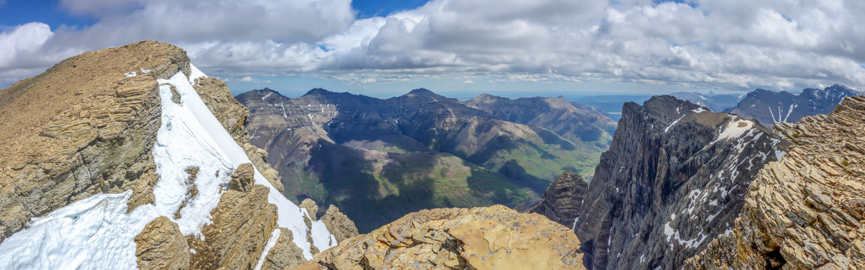
The final, northwestern segment of Anderson’s summit panorama. Click to see larger.
For some reason, “Kootenai Brown Peak” (foreground) is not officially named while the smaller Mount Bauerman behind it is. We’d entertained the idea of traversing from Anderson to Lost, then onto Kootenai Brown and Bauerman but the idea of forging headfirst into the Jetstream for hours on end proved unappealing! Beyond Bauerman, distant Kenow Mountain (center left – just touching the cloud ceiling) was the source of the lightning strike which razed most of Waterton to the ground in 2017.
Sage Mountain (center) and Castle/Windsor Peaks (center right) visible beyond Avion Ridge’s stoplight-themed (🔴🟡🟢) slopes.
Hoping for a better view of the Castle Wilderness to the north, I braved the wind to venture over to a northern outlier. The view towards Castle proved no better, however, the view back to towards Matt C., Scott and Mike (who had since joined us on the summit) made the small side trip worthwhile.
I needed to keep a steady grip on my phone to make sure that it didn’t blow away while I took a requisite summit selfie.
After 15 minutes of photography in the jet stream, we lost feeling in our fingers 🥶 and, so, began our retreat (aiming towards nearby Lost Mountain in the hope that the interceding col would be sheltered).
Just below the summit of Anderson, we stumbled upon a massive colony of ladybugs 🐞 clinging to the scree for dear life.
LEFT: Hoping to avoid blowing away like the ladybugs did, we continued down towards the Anderson-Lost col. Here, a funny thing happened; the jet stream abated and the wind became tolerable once more. Obviously, this meant that we were now “all systems go” to attempt Lost Mountain. 😉
RIGHT: Initially, the 93 vertical meter ascent to Lost Mountain looked mildly intimidating but it proved anything but. Even with snow, the ledges and steps were quite remarkably easy!
Only 30 minutes after we’d left Anderson, we found ourselves atop Lost Mountain for a rather cheeky two’fer. The panorama was, unsurprisingly, pretty much the same! Click to see larger.
Improved lighting on Mount Blakiston.
A slightly better view of Festubert and Lone Mountains.
Kootenai Brown Peak and Avion Ridge.
The real highlight of the day’s second summit: a little Southern Comfort buried in the cairn/register! Foolishly, I took a bigger gulp than one ought to before descending a mountain… 😵😬🤣
LEFT: With a view that was pretty much the same as that from Anderson, we didn’t linger long atop Lost and were soon retracing our steps down the ledges that comprised its NE ridge.
RIGHT: Back at the Anderson-Lost col, a long descent to the Blakiston Creek Valley awaited us. 😐
LEFT: Fortunately, that descent was expedited thanks to a few hundred vertical meters worth of glissading. While my hands had frozen on top of Anderson, I now found myself concerned with a frostbitten a$$. 😂
RIGHT: Leaving the snow behind, I stumbled upon this spring (which sprung forth rather suddenly and vigorously from the mountainside).
Springs and meltwater collect into a shared drainage, forming an impressive cascade. Click to see larger and play a game of “Where’s Waldo” with Matt Clay.
LEFT and RIGHT: Beautiful waterfall scenery to distract from the tedium of the steep, grassy descent.
LEFT: Eventually, the terrain mellowed, the waterfall became a creek and we returned to the the Blakiston Creek Valley's charred surroundings.
RIGHT: After hiking a short distance through the forest’s remains, we returned to the official trail and reacquainted ourselves with the noisy creek that would be our companion for the 1 hour hike back to the car.
Thanks to abundant wildflowers and argillite, the hike out was still charming (albeit a little less so than it had been 1400 vertical meters earlier in the morning 🥱).
LEFT: By the time that we made it back, the bridge over Bauerman Creek was a welcome sight as it marked the beginning of the end of this day’s adventure.
RIGHT: At 4:30 pm, Environment Canada’s forecast ☀️ finally came to pass (right as we got back to Red Rock Canyon 🙄). It may have been a little late but Anderson Peak certainly looked nice under “mainly sunny” skies!
Even with the overcast skies, hurricane-force winds, failure to "ride the wind", frozen hands/butt and suffer-fest slopes, the day ended up feeling like the treat I’d hoped for way back in January when the groundwork for this misadventure was laid.
.jpg)
.jpg)
.jpg)
.jpg)
.jpg)
.jpg)
.jpg)
.jpg)
.jpg)
.jpg)
.jpg)
.jpg)
.jpg)
.jpg)
.jpg)
.jpg)
.jpg)
.jpg)
.jpg)
.jpg)
.jpg)
.jpg)
.jpg)
.jpg)
.jpg)
.jpg)
.jpg)
.jpg)
.jpg)
.jpg)
.jpg)
.jpg)
.jpg)
.jpg)
.jpg)
.jpg)
.jpg)
.jpg)
.jpg)
.jpg)
.jpg)
.jpg)
.jpg)
.jpg)
.jpg)
.jpg)
.jpg)
.jpg)
.jpg)
.jpg)
.jpg)
.jpg)
.jpg)
.jpg)