Several weeks ago I opened my e-mail to find a new message from an old U of C chemistry colleague Cory. The e-mail inquired as to whether or not I’d be willing to take a vacation day at some point this September to join him for a midweek scramble. Although it was difficult to choose between a day in my windowless office and day spent in the grandeur of the Canadian Rockies, Cory’s repeated e-mail arm-twisting eventually convinced me.
After arranging for a Tuesday off work, Cory and I were both dismayed when the weather forecast predicted warm sunny days on Monday, Wednesday, Thursday and Friday. The forecast for our Tuesday off? You guessed it: cool temperatures and rain with snow at higher elevations. Fortunately, we were both able to rearrange our schedules on short notice so that we could escape on Monday instead.
After discussing several different targets, we settled on Redoubt Mountain in the hopes of catching some spectacular larch scenery in Skoki. Although Alan Kane recommends approaching Redoubt via Hidden Lake/Boulder Pass (8.6 km approach), we hoped to take advantage of Bob Spirko’s alternate route to shave off some time and distance in the hopes of being home in time for dinner!
.jpg)
After an alpine start, Cory and I parked at the Fish Creek trailhead and made quick work of the uninspiring Temple fire road. Hiking together for the first time, I was pleased to discover that Cory kept a very good pace. Despite the cool shade in the valley, we moved fast enough to stay warm but were still able to talk. With good conversation about mountains, life and mountains, the time passed quickly and before we knew it, we were high enough up the valley to catch our first glimpses of the beautiful larch forests adorning the slopes of Mount Richardson, Pika Peak and Ptarmigan Peak.
.jpg)
We weren’t the only ones who got off to an alpine start! This particular bruin heard our many calls aimed at warding off his kind but couldn’t have cared less as he indulged in the tasty breakfast treats that one finds on the slopes of the Lake Louise ski hill (photo courtesy Cory Jaska).
.jpg)
After making our way past the distant bear and the Temple Lodge, we continued to hike towards Skoki for a couple of km. At the second set of log bridges, we left the trail and aimed up the drainage.
.jpg)
At first we made our way up directly alongside the cascading stream, however, as the wet mossy slab made progress more challenging, we made our way up through the trees on the right instead. Despite appearances, the bush was thin and our progress through the forest was quick.
.jpg)
A very short time after leaving the main trail below, we emerged from the forest and found ourselves in a beautiful alpine cirque at the base of Redoubt Mountain’s steep western walls. After a quick stop to gawk at the larch trees, we continued upwards on the thinly forested grass slopes on the left.
.jpg)
As we left the last of the trees behind, we arrived at a pleasant flat area where we enjoyed a granola bar as well as the view of Mount Richardson before diving headfirst into the scree above us.
.jpg)
Looking up Redoubt’s western ramparts. Despite appearances, there’s a good moderate route to the summit from here. We ascended the grass in the center of the photo in order to avoid as much scree as possible (photo courtesy Cory Jaska).
.jpg)
Of course, the chossy rock could only be avoided for so long. Fortunately, step-like water-worn gullies gave some solid footing. The gray rock band above provided some very enjoyable scrambling (with an easy by-pass to the climber’s right for those looking to keep their hands clean).
.jpg)
Yours truly about to tackle the gray band (photo courtesy Cory Jaska).
.jpg)
Looking back down our ascent route towards the hazy Lake Louise panorama. Click to see larger.
.jpg)
Near the summit ridge, there are numerous options for fun hands-on scrambling directly above or easy (but loose) by-passes to the climber’s right. The proper (moderate) route to the summit takes advantage of a broad gully to the climber’s right of the buttress in the photo. A more difficult route up a tight gully to the climber’s left of this buttress is also possible (as I unintentionally found out)!
.jpg)
Eager to break through the cliffs guarding the summit, I tackled the difficult gully to the climber’s left of the buttress head-on. Although the holds were excellent, the gully was steeper than it appeared from below and, about half-way up, I realized that the fall distance below me was becoming significant. I felt comfortable ascending here but wouldn’t want to down climb this terrain. Fortunately for me, Cory opted to locate the easier gully to the right so that we’d be able to recognize it on descent (photo courtesy Cory Jaska).
.jpg)
Cory makes his way up the easier gully. Although less intimidating, this gully was very loose and we later descended it one-at-a-time to avoid cracking each other’s skulls open.
.jpg)
Once above the gullies, we made our way north towards Redoubt’s obvious and intimidating summit block.
.jpg)
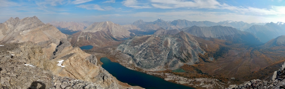
As we made our way up to the summit ridge, we were treated to our first spectacular views to the east, including the precipitous drop to Redoubt Lake and a larch-littered valley below. Click to see larger.
.jpg)
Despite its intimidating appearance, a break (the darkly colored ramp in this photo) on the west side of the summit block provided a moderate route to the top. With good route-finding (like Cory’s, not mine!), the Spirko route up Redoubt Mountain is a moderate scramble.
.jpg)
Cory scrambles up the final small rock band guarding the summit.
.jpg)
From the summit, the views deeper into Skoki were unbeatable! From left to right: distant Mount Drummond, Ptarmigan Lake, Fossil Mountain, Redoubt Lake (foreground), Baker Lake, Oyster Ridge, Mount Douglas, Mount St. Bride, Brachiopod Mountain, Tilted Mountain, Lychnis Mountain, Heather Ridge and Anthozoan Mountain.
.jpg)
Cory enjoys some lunch while taking in the hazy but spectacular summit panorama. Click to see larger.
.jpg)
Summit photo with Ptarmigan, Redoubt and Baker Lakes. In the background, Skoki Mountain looks positively diminutive compared to Fossil Mountain (photo courtesy Cory Jaska).
.jpg)
As with most Skoki Peaks, the view towards the front ranges is dominated by Mounts Douglas and St. Bride.
.jpg)
A closer look at Mount Douglas (photo courtesy Cory Jaska)…
.jpg)
…and of Mount St. Bride (photo courtesy Cory Jaska).
.jpg)
A colorful but unnamed tarn near Redoubt Lake.
.jpg)
The valley to the south of Redoubt Lake contained an unbelievable proliferation of beautiful golden larch trees while glaciated Bonnet Peak (left) and Pulsatilla Mountain (right) made for a dramatic backdrop. This colorful view was, without a doubt, the highlight of my day!
.jpg)
Wave upon wave of slate surges towards the Bonnet Icefield.
.jpg)
The hazy Lake Louise panorama to the south. From left to right: Panorama Ridge, Mount Bident, Mount Quadra, Lipalian Mountain, Mount Fay/Babel, Mount Little, Mount Bowlen, Mount Tonsa, Mount Perren, Mount Allen, Mount Tuzo, Deltaform Mountain, Neptuak Mountain, Mount Temple, Mount Hungabee, Ringrose Peak, Mount Lefroy, Mount Aberdeen, Fairview Mountain, Mount Victoria, Lake Louise, Popes Peak, Mount Whyte, Mount Niblock, Narao Peak, Cathedral Mountain and Whitehorn Mountain (complete with backside of Lake Louise ski runs). Click to see larger.
.jpg)
The Valley of the Ten Peaks and Mount Temple tower high above the top of Lake Louise ski resort’s “Larch” chairlift.
.jpg)
The crown jewel of the Canadian Rockies: Lake Louise and Mount Victoria beyond the larch-filled approach valley and ski hill.
.jpg)
The hazy summit panorama to the west includes (from left to right) the many peaks of the Louise area, Whitehorn Mountain (and its many larch trees), Hidden Lake, Mount Richardson, Pika Peak and Ptarmigan Peak. In the distance, the many peaks of the Waputik and Wapta Icefields are faintly discernable. Click to see larger.
.jpg)
Prominent icefields peaks make up the spine of the continent to the west.
.jpg)
Glaciated icefields giants (from left to right): Mount Niles, Mount Daly, Mount Balfour, Mount Collie and Mount Gordon.
.jpg)
Hidden Lake occupies yet another larch-littered valley at the base of Mount Richardson.
.jpg)
Massive Mount Hector’s Snoopy-shaped summit just visible beyond Richardon’s flank (photo courtesy Cory Jaska).
.jpg)
Hidden Lake is actually quite apparent from up here!
.jpg)
Mount Richardson, Pika Peak and Ptarmigan Peak (photo courtesy Cory Jaska).
.jpg)
For once there was someone else with a camera around to take pictures of me (thanks Cory)!
.jpg)
Cory readies himself for the camera timer summit dash after constructing his very own “tripod” (lithopod?).
.jpg)
Group summit shot before heading back down from whence we came (glad the “tripod” was well-constructed)!
.jpg)
Retracing our steps back through the rock bands in the hot afternoon sun.
.jpg)
Making my way down the gray rock band (thank God Cory was there to capture the awkward butt-shuffle descent that followed – photo courtesy Cory Jaska).
.jpg)
With all the fun scrambling behind us, we made our way back down alongside the colorful stream towards the dull main trail below.
.jpg)
Cory tries to avoid turning the stream into a waterslide.
.jpg)
After reaching the main trail, we lumbered back towards the trailhead, dreading the final walk out along the rock hard Temple fire road. As luck would have it, however, we timed our descent PERFECTLY and arrived at Temple Lodge just as the Skoki Lodge shuttle bus was departing! Fortuitously, the shuttle had 2 empty seats and the driver was kind enough to take us aboard, negating the final 4 km of our day!
Good company, golden larches, glacier-topped peaks, five-star scrambling AND a free ride out – sure beats a day at the office!
.jpg)
.jpg)
.jpg)
.jpg)
.jpg)