“Is Mount Aberdeen a scramble?”
For years, enthusiastic peak baggers have been infatuated with the possibility of climbing this glaciated Lake Louise giant. Indeed, every time that someone posts a report outlining their ascent of the far more popular north glacier route, the first response is often from scramblers seeking beta.
“Sounds like there is an easier way up the backside?”
“My understanding is that one can ascend the climber’s descent route as a scramble. Is it moderate or difficult?”
After asking similar questions many times, I decided that it was about time that someone bashed up Paradise Valley and put an end to this mystery once and for all! In March 2015, local peak bagging legends Vern Dewit, Steven Song and Ben Nearingburg took the first step towards answering this question when they attempted a risky winter ascent of Aberdeen via Paradise Valley. While they successfully summitted, their route ended up looking anything but non-technical! Nevertheless, their reports provided invaluable info and reignited my desire to investigate Aberdeen’s rumored scramble route.
As spring turned to summer, I began to reach out to other committed peak baggers in an attempt to get a group together for this somewhat exploratory outing. From what beta was available, we knew that the ascent would likely involve:
• Hiking up Paradise Valley with the possibility that a group of 4 would be required thanks to
trail restrictions put in place to deal with bears.
• Making use of the now decommissioned trail system further up-valley.
• Crossing a raging Paradise Creek to stay on the decommissioned trail or thrashing through reputedly nasty brush to avoid river fords.
• Ascending miserable scree with little idea as to how steep and difficult things would get. A descent route which is “easy” for climbers often presents a challenge for scramblers.
Despite these uncertainties, I found that several others shared my desire to scramble up Aberdeen and plans were put in place to do so. Of course, the Rockies have a way of thwarting the best-laid plans and, after a couple of cancellations due to shitty weather, most of the group finally decided to take a day off work on short notice when conditions finally looked good (I’m still sorry that the Golden Scramblers were not able to join us while we played hooky). After nearly running out of gas on the drive to Lake Louise (woops!), Matt Clay, Mike Mitchell and I assembled at the Paradise Valley trailhead early on a Thursday morning eager to lay the mystery of Mount Aberdeen’s scramble route to rest. Is it a scramble? How miserable is the bushwhack? Will steep terrain ultimately turn us back? Time to find out!
.jpg)
The picturesque Aberdeen Glacier and its aesthetic ice climbing route flow down from the col between Haddo Peak (left) and Mount Aberdeen (center) (as seen from the summit of nearby Fairview Mountain).
.jpg)
I’m not a huge fan of the hiking trail up Paradise Valley (it’s long and mostly in thick forest) but Paradise Creek and its tributaries are beautiful nonetheless. The last time that I navigated this trail, a comedy of errors led to numerous wrong turns. This time around, however, we simply followed the signs for Lake Annette until we reached the fork where the old decommissioned trail parts from the current Paradise Valley trail.
.jpg)
A bridge crossing Paradise Creek provides our first open view of the day as Sheol Mountain rises steeply skywards. Sheol may look big from here but it’s actually an outlier on the Aberdeen massif. The summit of Mount Aberdeen is almost 400 m higher still!
.jpg)
After travelling about 5 km in a little over an hour, we reached the fork where the current and decommissioned trails part ways. A plethora of signs make this a fairly obvious landmark. Continue straight ahead over deterrent logs if you wish to scramble up Sheol Mountain or Mount Aberdeen. The other trail ascends the valley opposite these peaks towards Lake Annette, the Giant Steps and, ultimately, Sentinel Pass.
.jpg)
Matt enjoys relatively easy travel along the decommissioned trail. Despite occasional deadfall, this trail is still a highway by Rocky Mountain standards!
.jpg)
After a few minutes on the decommissioned trail, we passed the well-flagged avalanche slopes used to ascend Sheol Mountain. Although Sheol is a pleasant scramble, we set our sights a little higher (370 m) on this day!
.jpg)
Further along the decommissioned trail, another avalanche path descends from the col between Mount Aberdeen (left) and Haddo Peak (right). While this opening granted us our first views of Aberdeen, we continued past it towards the major drainage immediately west (left) of Aberdeen’s summit.
.jpg)
The end of the road…Mike consults his GPS as we reach the point where the decommissioned trail crosses Paradise Creek. When Parks Canada decommissioned the trail, they removed the bridges which had been present at every creek crossing. As a result, one can now choose to ford fast-moving Paradise Creek or to continue through the brush along the creek’s north bank. If you cross the creek here, you’ll need to cross back again to access Aberdeen’s ascent drainage. This approach dilemma seems to be a major deterrent for most scramblers.
.jpg)
Diving into the bush! No one likes bushwhacking but the distance (about 1 km) between the ascent slopes and the end of the old trail system is relatively short (mercifully). On ascent, we stayed well away from Paradise Creek, veering uphill to the climber’s right. This resulted in brutal bushwhacking initially, however, it later led to a thinly forested area. On descent, we stuck by the creek and found a thin trail at first, however, this eventually gave way to hellacious bushwhacking. Regardless of which way you choose, be prepared for this bushwhack to half-suck!
.jpg)
Not nearly as pleasant as it looks! ;-)
.jpg)
The thick forest gives way to the huge avalanche run-out at the base of Mount Aberdeen’s scramble route (photo taken much later in the day on descent). The route proceeds up open avalanche slopes, through a small canyon and up endless scree towards a high col. From the high col, a steep (but non-technical) ramp hidden on the backside grants access to the summit on the climber’s right. Mouse over for route line.
.jpg)
With the thick brush finally behind us, colorful wildflowers abound on open slopes while Mount Hungabee towers at the head of Paradise Valley.
.jpg)
Indian Paintbrush-whacking!
.jpg)
Making our way up towards the canyon feature. By now the day was brutally hot (30+ degrees C) and we raced towards the small spot of shade at the canyon’s mouth for a brief respite from the unrelenting sun!
.jpg)
A rushing mountain stream pours down in the shade of the canyon while we break for lunch #1.
.jpg)
Break over! Matt starts to grind upwards again alongside the noisy little stream. Faint paths in the canyon suggest that this route still serves as an option for climbers during their descent.
.jpg)
Eventually, our companion creek disappeared below the bottomless rubble as we hiked up into a massive alpine bowl.
.jpg)
Mike hides from the sun in, what would prove to be, the last shade between us and the summit.
.jpg)
Onwards and upwards! Matt is dwarfed by the steep towers which run alongside the rubble route to the high col (left).
.jpg)
If you do decide to scramble Mount Aberdeen, get used to seeing this! It will be your only view for a long, long time!
.jpg)
Higher up, we got a 180 vertical meter reprieve thanks to a lingering snow patch. Kicking steps was pure bliss after the scree slog below.
.jpg)
Matt follows in Mike’s expertly-kicked steps amidst an improving view of Paradise Valley below.
.jpg)
Paradise panorama at the base of our rubble road. Click to see larger.
.jpg)
Above the snow, the rubble grows less pleasant but no more technical as we work our way up to the col.
.jpg)
The “OH WOW!” panorama from the col! When I first started to climb mountains, most summits provided “OH WOW!” views but, as I became more accustomed to summiting, it got harder to find places that really made my jaw drop. Upon seeing this, however, I couldn’t help but be awestruck! Fuckin’ eh! Click to see larger.
.jpg)
After stopping for a lengthy photo break at the scenic col, we eventually had to put the cameras away and resume our ascent. The summit ramp up from the col is every bit as steep as it appears; fortunately, the gray boulders here were unexpectedly stable!
.jpg)
Consider the debate closed! Mount Aberdeen is an easy scramble (class 2 – minimal use of hands, no exposure! It may be a thrash and then a slog but this summit panorama, stretching from Mounts Lefroy and Victoria (left) towards Lake Louise and the Aberdeen Glacier (right), provides ample reward! Click to see larger.
.jpg)
Finally On Top of Mount Aberdeen after years of wanting. :-D
.jpg)
Mounts Lefroy and Victoria provide an up-close, show-stealing view!
.jpg)
Cascades freefall down hundreds of vertical meters on Mount Lefroy’s sheer east face. Mouse over for a closer look at Lefroy’s impressive gravity-defying glacier from which these waterfalls originate.
.jpg)
Mount Victoria is probably the most photographed peak in the Canadian Rockies (and rightly so). Mouse over for a closer look at the Victoria Glacier’s precarious seracs.
.jpg)
Seriously – WOW. From left to right: Hungabee Mountain, Ringrose Peak, Mount Lefroy, Mount Victoria, Collier Peak, unnamed, Pope’s Peak, Vatican Peak, the Wapta Icefield (distant), Mount Whyte, Mount Niblock, Mount St. Piran, Mount Hector (distant), the Big Beehive, the Little Beehive and the crown jewel of the Canadian Rockies – Lake Louise. Click to see larger.
.jpg)
A bird’s eye view of the Plain of Six Glaciers. Mouse over for a closer look at the famous tea house.
.jpg)
Looking towards the Wapta Icefield – from left to right: Mount Des Poilus, Mount Collie, Mount Niles, Mount Balfour and Mount Daly.
.jpg)
Lake Louise, nestled between Mount St. Piran (left) and Fairview Mountain (right), looks more like a puddle than a lake. Mouse over for a closer look at Louise’s brilliant blue glacier-fed water.
.jpg)
The Aberdeen Glacier drops steeply downslope while the Paradise Valley panorama stretches from Lake Louise (left) to the unofficially named Horseshoe Lakes (right). Haddo Peak (center left) and Mount Temple (center right) further highlight the view. Click to see larger.
.jpg)
A closer look at Haddo Peak (only 70 m lower than Mount Aberdeen). From Aberdeen, the traverse to Haddo looks very tempting but scramblers be warned: some simple glacier travel is required to get there! Knowing that these 2 officially named peaks were so close to one another, we (of course) discussed bagging them both while we were “in the neighborhood.” The feasibility of this little venture would depend heavily upon how difficult/dangerous the traverse looked from Aberdeen…
.jpg)
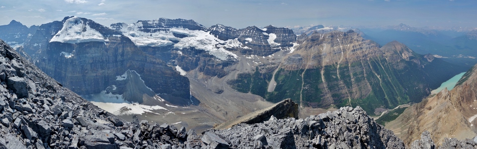
More WOW as Paradise Creek charts a course down the lush green valley below. High above the creek, massive peaks pierce the sky – from left to right: Protection Mountain (distant), Castle Mountain (distant), Little Temple, Mount Temple, Mount Fay, Mount Little, Mount Bowlen, Tonsa Peak, Pinnacle Mountain, Mount Perren, Mount Allen, Eiffel Peak, Tuzo Peak, Deltaform Mountain, Wastatch Mountain, Neptuak Mountain, Oke Peak (distant), Helmet Mountain (distant), Wenkchemna Peak, Mount Hungabee, the Mitre, Ringrose Peak, Mount Lefroy and Mount Victoria. Click to see larger.
.jpg)
Sentinel Pass separates the picturesque north face of massive Mount Temple (left) from the much smaller Pinnacle Mountain/Eiffel Peak tandem (right). For those looking for spectacular on-trail views, hikes don’t come much prettier than the popular trail up Sentinel Pass!
.jpg)
All 10 of the famous “Valley of the Ten Peaks” summits in one shot (Mount Fay, Mount Little, Mount Bowlen, Tonsa Peak, Mount Perren, Mount Allen, Tuzo Peak, Deltaform Mountain, Neptuak Peak and Mount Hungabee). It’s surprisingly tricky to line up a photo showing all 10 of these summits in a row!
.jpg)
The Horseshoe Glacier and its namesake lakes nestled along the base of Mount Hungabee at the head of Paradise Valley.
.jpg)
Mike checks out the exposed ridge connecting Mount Aberdeen and Haddo Peak. Having concluded that Aberdeen is no more than a class 2 scramble, perhaps Haddo can be scrambled as well? Only 1 way to find out for sure - onwards to Haddo Peak!
.jpg)
.jpg)
.jpg)
.jpg)
.jpg)
.jpg)