Powderface Ridge
Elevation: 2130 m
Elevation Gain: 630 m
Powderface Ridge is an 8 km long grass and tree-covered ridge which lies along the eastern edge of the front ranges. The ridge was officially named in 1949 for a Stoney aboriginal (Tom Powderface) who lived in nearby Bragg Creek.
My Ascents:
May 24 2015, February 22 2014, Summer 1986.
Trailhead: Powderface Trail South Winter Closure Gate
GPS Track: Powderface Ridge
Following a LONG outing up Armor Peak on Saturday May 23, it was tempting to stay home on Sunday the 24th. My boots were soaked, my feet were blistered and my legs were tired. But that wouldn’t have been fair to Crux. Having (mercifully) been left at home for Armor Peak, Crux was just itching to get out to the mountains on Sunday (or perhaps he was just itching because of fleas). Although I didn’t want to go hiking, I decided to put Crux’s interests ahead of my own and joined my parents for a brief but scenic outing up Powderface Ridge.
.jpg)
The summer trailhead for Powderface Ridge is located at the Powderface Trail road closure/Little Elbow turnoff on Highway 66 and is infinitely preferable to the winter access which requires a more lengthy approach from Elbow Falls. As you can see from the parking situation, this is a popular objective so solitude-seekers and nude sunbathers are advised to look elsewhere!
.jpg)
Crux can’t remember the last time that I took him up anything with a trail this substantial!
.jpg)
With the benefit of such a good trail, elevation gain was quick and the forest soon became sparse. As we ascended, we passed a couple of grassy outliers to the east (climber’s right); the high point of the ridge, however, is just west of the trail.
.jpg)
You never know who you’ll cross paths with on such a popular trail.
.jpg)
Mom stops to enjoy the ever-improving view of the Elbow River (left) and Little Elbow River (right).
.jpg)
The best way for hounds to cool off on a hot day!
.jpg)
Near the second eastern outlier, the trail continues on through forest just below the actual ridge crest. The shaded east aspect here was collecting more snow than we cared to wade through, however. Deciding that the view from the outlier was good enough, mom stopped there for lunch with a crowd. Meanwhile, Gord and I made use of an obvious clearing to gain the ridge proper.
.jpg)
A faint trail through the steep forest above the clearing suggests that we aren’t the only ones who’ve opted to leave the main trail below. This trail quickly brought us to Powderface’s long, level ridge crest.
.jpg)
Colorful rubble gives way to an impressive view of snow-capped Banded Peak, Outlaw Peak and Mount Glasgow from the ridge crest.
.jpg)
Happy to be back in his element!
.jpg)
The old man was also happy to be back in his element on the southern summit of Powderface Ridge. The ridge has 2 main high points (which share the same contour line on topo maps). We used the GPS in an attempt to figure out exactly where the summit was and this may well have been it. Google Maps shows the more northerly high point as the true summit but, with mom waiting on the outlier below, we weren’t about to traverse a kilometer there and back just to find out.
.jpg)
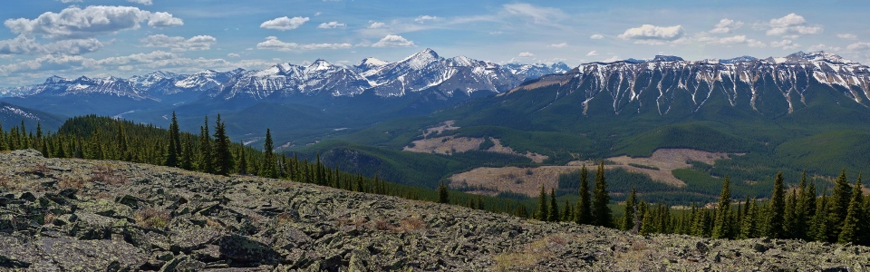
A very pleasant front range panorama highlighted by the Banded – Glasgow group (left) and arrow-straight Nihahi Ridge (right). As a short hike only 45 minutes outside of Calgary, Powderface Ridge is definitely a worthwhile ascent (once anyways)! Click to see larger.
.jpg)
The Elbow River winds through the valley below Bluerock Mountain (left), Threepoint Mountain (center) and Mount Burns (right).
.jpg)
A closer look at Banded Peak.
.jpg)
Snowy Mount Cornwall peers out from behind pyramidal Mount Glasgow. The Banded-Outlaw-Cornwall-Glasgow quartet is one of the most obvious groups of peaks visible from Calgary.
.jpg)
Mount Blane and its “Blade”-shaped outlier are the most obvious of the Opal Range summits visible up the Little Elbow Valley from Powderface Ridge. These peaks are more frequently seen from Kananaskis Trail (Highway 40) on their other side.
.jpg)
The 8 km length of Nihahi Ridge parallels Powderface Ridge to the west.
.jpg)
Fisher Peak (more distant) and Mount Fullerton make an appearance beyond Nihahi Ridge.
.jpg)
Powderface’s northwest outlier which Crux and I mistook for the summit during a frigid February whiteout last year.
.jpg)
Compression Ridge and Mount Bryant lie beyond the outlier.
.jpg)
The peaks of the Ghost Wilderness and Bow Valley faintly visible beyond Belmore Brown Peak and the outlier. If you squint, you can even discern Yamnuska and its well-used scree run down on the center right!
.jpg)
All the Hobbs men on top.
.jpg)
Mom, on the outlier below, wondering where she lost her boys. Meanwhile up top, I was wondering where I lost my hiking pole. Mom ended up finding her boys but I never did find that damned pole!
.jpg)
Mom or no mom Pole or no pole, it was time to head down. The second eastern outlier can be seen behind Gord; this is where mom (and most others) call it a day.
.jpg)
Even with sore legs and blisters from the day prior, the descent offered what could only be described as pleasant alpine wandering with views towards Forgetmenot Ridge and the Elbow River below. The things that I do to satiate Crux’s longing for mountain exploits!...
.jpg)