Elevation: 2720 m
Elevation Gain: 525 m
Wonder Peak was named by Arthur O. Wheeler and Konrad Cain following their successful first ascent on September 26, 1913. Recalling his ascent, Wheeler noted: "The peak and pass are so called on account of the wonderful view that meets the eye from their summits: Marvel Lake, Lake Gloria, and a huge amphitheatre of glaciers, with a setting of green forest, suddenly appearing." Wonder Peak’s true summit is the easternmost high point located along a crumbling arête. “Little Wonder” is the unofficial name of a high point immediately above Wonder Pass at the western end of Wonder Peak’s fractured summit ridge.
My Ascents:
September 18 2018
Trailhead: Magog Lake GPS Track: Little Wonder
To celebrate my dad’s 70th birthday, I arranged for he and I to escape to Mount Assiniboine Provincial Park for 4 days and 3 nights in September, 2018. Having had his hip replaced a year earlier, Gord was just now starting to recover to the point that would allow him to get back to the hiking and peak bagging that he so loves. Fortunately, the Assiniboine area is replete with spectacular scenery and hikes suitable for celebratory father-son adventures.
After skipping the 25 – 30 km hike into the Park via helicopter, we spent our first day amidst snow and cloud with little to see. Day 2 dawned much the same but saw the clouds lift and views improve as we descended from Nub Ridge.
The 3rd day of our Assiniboine adventure dawned clear and cool and we found ourselves excited to get out of the hut well before dawn. Why waste time sleeping when you’re in the most beautiful place on Earth?!
Assiniboine Sunrise:
With the previous days’ heavy cloud cover miraculously dispersed, we were eager to watch the sun cast its golden alpenglow on the “Matterhorn of the Rockies.” We, therefore, made our way past the Assiniboine Lodge by headlamp and returned to a scenic tarn we’d discovered the day prior. Once there, we enjoyed the peace and still (and chill!) of the early morning.
Still morning water reflects Mounts Magog and Assiniboine. After days of thick cloud, we were blessed with completely clear skies to start this day (save for a dramatic plume emanating from Assiniboine’s sharp summit). Photo courtesy Gord Hobbs.
Enjoying a quiet mountain morning together – this is exactly what I’d hoped for when surprising my dad with this trip for his 70th birthday!
Mere moments before sunrise, our tranquil tarn became less-so following the arrival of a large guided group. While we’d have preferred to enjoy the sunrise by ourselves, there was more than enough beauty around to share. Photo courtesy Gord Hobbs.
One of nature’s great spectacles: the day’s first light warms the glacier-scoured faces of Mounts Magog and Assiniboine. Photo courtesy Gord Hobbs.
A dramatic sunrise panorama bodes well for the day ahead! From left to right: The Towers, Naiset Point, Terrapin Mountain, Mount Magog, Mount Assiniboine, Wedgewood Peak and Sunburst Peak. Click to see larger.
After (temporarily) sating our desire for grand mountain vistas, we returned to the Naiset Huts to enjoy a hot breakfast (mmm…instant oatmeal again!), warm up and discuss potential targets for, what promised to be, a spectacular day of hiking.
Little Wonder:
After discussing several potential objectives (and noting that they were all quite snowy), we settled on Little Wonder since our wanderings had yet to take us south towards Wonder Pass. As an added bonus, we knew that the trail to the pass would be well-packed down so we’d have a couple kilometers of easy travel before the more strenuous trail-breaking started in earnest.
From the huts, we followed a boardwalk which ambles south through alpine meadows towards Wonder Pass (unseen and just out of frame to the left). Photo courtesy Gord Hobbs.
Shortly after setting out, we reached Gog Lake and were greeted by one of the finest scenes that I’ve witnessed in the Rockies. Mirror-like, the lake’s cold, clear waters reflected glowing golden larch trees, a suddenly blazing September sun and the striking, snow-covered silhouette of the Towers. Click to see larger.
After reluctantly tearing ourselves away from Gog Lake, we followed the well-travelled Wonder Pass trail as it gained elevation through larch forests and passed a small cascade. Photo courtesy Gord Hobbs.
After days of flat lighting, the larches (and Gord!) seemed to suddenly glow in the sunlight.
Thinning forests reveal our first views towards Wonder Pass (right), Little Wonder (center) and Wonder Peak (center left).
After a gentle climb, we reached Wonder Pass and gazed south into Alberta.
The sun casts a golden glow on nearby “Penny’s Peak” and its larch-laden flanks while Mount Byng (left) and Aurora Mountain (center) tower above in the shade. Sitting at the pass and staring towards “Penny’s Peak” (which I named for my second daughter 1 month before her birth), I was filled with emotion. I was thrilled to finally show my dad his granddaughter’s peak but found myself suddenly missing my “Baby Bear”, her older sister and her mom. As tears welled up in my eyes, I felt strangely close to Penny but, at the same time, far, far away. I really can’t wait to return to this area with all of my girls.
The other half of the Wonder Pass panorama. Looking north into BC, the Towers tower above (left), Naiset Point points skyward (center left) and Mount Cautley (right) looks somewhat pedestrian despite the fact that it’s higher than either of the former peaks. Confoundingly, the Alberta-BC border runs along all of these summits, making Assiniboine Provincial Park feel like a pocket of BC which juts east into Alberta. Click to see larger.
Wonder Peak (center) and “Little Wonder” (right) rise impressively to the east of Wonder Pass. From here, we left the packed trail and followed the Continental Divide up the peak’s northwest ridge (rising from left to right in this photo).
When dry, a scree trail winds its way up this flank to Little Wonder, however, we saw little evidence of it under the recent snow! The ascent was neither “crazy steep” nor “gentle” but rather somewhat moderate. Some aspects were certainly steep enough to slide so caution is merited if you attempt Little Wonder in snowy conditions. Fortunately for us, this early season snow felt remarkably stable. This allowed me to kick steps for us, essentially pounding a temporary staircase into the slope. Photo courtesy Gord Hobbs.
Mount Eon makes a dramatic appearance as we continue to kick-step our way up and up and up. Photo courtesy Gord Hobbs.
Gord follows me up a windswept section of ridge as Gog and Magog Lake come into view beyond larch-filled alpine meadows.
Indian Peak (center left), Nestor Peak (center) and Nub Peak (center right) rise above an amber larch carpet to the north. Photo courtesy Gord Hobbs.
Wonder Peak makes for an equally spectacular view to the east. As we ascended, we carefully probed to ensure that we didn’t accidentally wander off solid ground and onto a cornice. While the peak’s shaded north face made for nice eye candy, we had no particular desire to find ourselves falling off of it! Photo courtesy Gord Hobbs.
Afternoon clouds create a dramatic backdrop for nearby Mount Eon (left), Aye Mountain (right) and the great glacier which rests between them. Photo courtesy Gord Hobbs.
A closer look at Aye Mountain’s sheer east face. While neighboring Mount Assiniboine probably sees hundreds of ascents per year, Aye has only been climbed a handful of times (3 as of Rick Collier’s 1997 trip report).
The Old Man enjoys ever-improving scenery as we near the summit of “Little Wonder.” It would have been impossible to even imagine this scene a year and half ago when he could hardly walk while waiting for hip replacement surgery and it's inspiring to see him (and his new titanium hip) back to bagging peaks now!
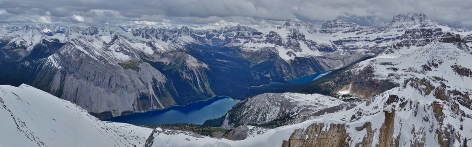
Upon topping out, we were greeted by a wondrous panorama towards Marvel Lake (left), tiny Terrapin Lake (center) and Lake Gloria (right). With a patchwork of afternoon cloud casting shadows and dramatic light across the mountainscape, there was certainly nothing “little” about “Little Wonder’s” summit view! Click to see larger.
The sun lights up an island of larches on Marvel Peak’s north flank while Marvel Lake fills the valley below with its shades of moody blue.
Marvel Peak (left) and “Penny’s Peak” (right) glow in the sun. With clouds casting shadows on about 90% of the surrounding peaks, I couldn’t help but feeling blessed that my daughter’s peak was one of the few that were naturally highlighted for us.
Mount Gloria’s glacier-clad trio of summits rise above Lake Gloria while Mount Eon towers, higher-still, behind. Further south, Mounts Brussilof and Alcantara brood in the shade beyond Marvel Pass.
Words cannot express how much it means to me to be able to share summit views like this with my dad once more!
Glacier-fed Lake Gloria glows below spectacular Mount Gloria, Mount Eon and Aye Mountain.
A closer look at tiny Terrapin Lake (left) and Lake Gloria (right).
The giants of the Assiniboine Group (Eon, Aye and “the Matterhorn of the Rockies” itself) dominate the panorama to the west which stretches from Marvel Lake and Pass (left) to Magog Lake and meadows (right). Photo courtesy Gord Hobbs. Click to see larger.
Looking back towards Gog Lake and Magog Lake. To the right, bright red roofs make it easy to spot the Naiset Huts. Photo courtesy Gord Hobbs.
Looking north beyond the sun-splashed (but nightmarish) Valley of the Rocks. In the shade beyond, the snowy Sunshine Meadows stretch out below diminutive Citadel Peak (center) and much larger Golden Mountain and Nasswald Peak (right). Photo courtesy Gord Hobbs.
Although I was thoroughly enjoying “Little Wonder” with my dad, I, unfortunately, couldn’t leave well enough alone. The siren song of Wonder Peak’s “nearby” summit was calling and, like a sailor drawn towards doom on the rocks, I couldn’t resist…
Wonder Peak Attempt:
With Wonder Peak’s summit tantalizingly close (about 500 m away and 130 m higher), I set off to investigate the route along its crumbling summit ridge. The view from “Little Wonder” looked innocent enough, however, even the first snow patch that I crossed felt suddenly steeper once I was actually on it. As I would soon learn, much of the ridge’s fiercer terrain is hidden from “Little Wonder”. Photo courtesy Gord Hobbs.
Further from “Little Wonder”, the ridge’s true character is revealed. The exposure to the climber’s left (north) was extreme (even overhanging) while terrain on the climber’s right (south) steepened significantly. It was often possible to avoid difficulties by scrambling along ledges and scree to the climber’s right but, from time to time, I needed to brave the more exposed crest. In dry conditions, I’d rate the traverse as a solid moderate scramble but, with the snow that I had, it felt quite daunting. As I made my way along the ridge, I found myself entering that zone of pure focus where the rest of world peels away and time stops. All that mattered was my next foot placement or hand hold.
Sneaking a peak at the exposure down the ridge’s north face while crossing a narrow snow arête.
Nearing the traverse’s end, the peak’s intimidating summit block finally appeared (click to see larger). So Nakagawa’s trip report suggests that the right hand chimney may be moderate scrambling. To reach this feature, however, I would have had to cross a couple of meters of extremely steep (60 – 70 degrees), snow-covered rock which ran out all the way down the peak’s sheer north face. Vern Dewit mentions contouring to the right below the summit block and then gaining it from the backside, however, the traverse below the summit block looked too steep for the snow conditions I encountered. When dry, there may even be a scree path to follow but, when I investigated, all that I saw was the potential for a long slide down to Marvel Lake. Nakagawa’s report also highlighted a third option: climbing directly up ledges on the summit block’s right (south) side.
Up close and personal with Wonder Peak’s summit block! Feeling that So’s difficult ledges represented my best chance to get up, I made my way over to them. As I reached their base, I agreed with So’s assessment that they’d be difficult scrambling. The holds were large but, like the rest of the ridge, were not always solid. Complicating matters, I didn’t like the feel of the wet/snowy rock beneath my boots. Despite wavering faith in the rock quality and my boot’s grip, I started up. After completing 3 or 4 moves, I decided to reverse them to see how easy they would be to downclimb. None of these moves felt too sketchy on ascent but, when reversed, they felt extremely awkward. Seeing as I’d climbed 1 – 2 of the required 10 m, I decided that I wouldn’t be able to comfortably downclimb this route solo and ended my attempt. I’d be curious to return to Wonder Peak in dry conditions to investigate Vern’s “contour around and up the backside” route. He is, however, a much more daring scrambler than I am and even he notes that the final 10 m of this route were still reasonably exposed.
A sub-summit look towards Gog Lake, Magog Lake, Naiset Point, Sunburst Peak, Indian Peak, Sunburst Lake, Cerulean Lake, Nestor Peak and Nub Peak. Although I was disappointed to be stopped just short of the summit, I’m certain that this view looks the same from a mere 10 m higher!
Summit or not, the panorama to the south and west was undeniably wondrous! Click to see larger.
Cone Mountain (left) and Mount Turner (right) bookend the Bryant Creek Valley (which our helicopter flew up a couple days earlier). More distant, a host of familiar Kananaskis peaks are also apparent including (from left to right): Mount Engadine, the Tower, Mount Galatea, Mount Chester, Tent Ridge (middle ground), Mount James Walker and Kent Ridge.
The British Military Group rises up beyond Mounts Turner and Morrison.
Nearby Marvel Peak, Lake and Pass.
An impressive glacial amphitheatre between Mount Gloria, Eon Mountain and Aye Mountain serves as the headwaters for Lake Gloria, Terrapin Lake and Marvel Lake.
The sad face didn’t-quite-make-it selfie.
Meanwhile, back on “Little Wonder”, Gord monitors my progress with the help of his telephoto lens. Mouse over to see how painfully close I came to the true summit. Photos courtesy Gord Hobbs.
After a very brief photo break on Wonder Peak’s last false summit, I turned my attention back towards the daunting ridge which I’d need to follow back down (mouse over to see my approximate route). With a trail broken through the snow, the return trip was a little easier but I was forced to constantly remind myself to stay alert. Just because I had footprints to follow this time didn’t mean that I could afford to slip!
Following many careful foot placements, I made it back to “Little Wonder” where Gord had been patiently waiting for almost an hour and a half. Photo courtesy Gord Hobbs.
With the day’s most dangerous terrain now behind me, I immediately felt awful that I’d left Gord for so long. Would it have been so awful to stay on the beautiful but slightly smaller peak with my dad? His accomplishment making it up “Little Wonder’s” snowy summit with a new hip at 70 years old was remarkable and we should have enjoyed it together. That had been the point of this trip after all. Instead, I darted off to feed my peak-bagging obsession and, perhaps deservedly, didn’t even make it. I immediately apologized. To his credit, Gord assured me that no apology was required and that he understood. Content that I’d not ruined our day (or fallen off the mountain trying), we started back down.
The old man with the bionic hip carefully descends one of many steep snow slopes.
Once we’d made it safely down to Wonder Pass, another matter of the utmost importance came to our attention. Thanks to my longer than expected diversion up high, it was now 4:25 pm and last call at the 3 km-distant Assiniboine Lodge’s “Happy Hour” (aka: public tea) was 4:50 pm. Knowing full well that Gord’s new hip could not cover that distance in 25 minutes, we again agreed to separate so that I could book it to the Lodge to buy celebratory beers for us. While Gord had been reluctant to part ways up high, he was much more supportive of my decision to (literally) run ahead this time! Photo courtesy Gord Hobbs.
While I sprinted downhill (in mountaineering boots with a heavy pack no less), Gord enjoyed a leisurely hike down from Wonder Pass, stopping often to take pictures of the area’s many lovely larches. Photo courtesy Gord Hobbs.
All’s well that ends well (and a day that ends with a bag full of beer can certainly be said to have ended well)! After setting a land speed record between Wonder Pass and the Assiniboine Lodge, I arrived at 4:49 pm and ordered a pile of beer “to go”. After all, Gord and I had worked up a wondrous thirst! Photo courtesy Gord Hobbs.
After enjoying our ales, some dehydrated food and some spectacular leftovers from our generous hut-mates, we settled in for our last night in the Assiniboine area.
Adieu Assiniboine:
With our helicopter back out of the Assiniboine area scheduled to leave at 10:30 am, we didn’t have enough time to complete another hike on our final day and, so, focussed on packing up our gear and enjoying the spectacular scenery near the Naiset Huts and Assiniboine Lodge.
Just because there was no time to hike didn’t mean that we were about to sleep in, however! Having noticed clear skies when I woke to use the men’s room at 5:00 am, I decided to attempt some mountain astrophotography. Given that I was using a point-and-shoot camera and a log-chair-for-a-tripod, I’m pretty pleased with how it turned out!
Saying “Goodbye” to our wonderful hut-mates Craig, Sharon, Peter and Donna. We couldn’t have asked to share the Forget-Me-Not hut with better people! A special thank you to each of you for making our time in Assiniboine Provincial Park so enjoyable. While my website will recount Gord and I’s hiking adventures, we’ll both remember the lively conversations, excellent food and fun that we had with you guys after dark each night! Photo courtesy Gord Hobbs.
PS: if any of you should happen upon this blog, please email me that tangine recipe! That was unbelievably good!
After bidding our hut-mates “adieu” and dropping our gear off at the helipad, Gord and I wandered down towards Magog Lake to enjoy the beautiful morning. Photo courtesy Gord Hobbs.
Spectacularly clear skies make for a magnificent Magog Lake panorama. Click to see larger.
Morning sun on Mount Magog.
While we were sad to say “Goodbye” to our hut-mates, we were even sadder to leave “the Matterhorn of the Rockies” behind (especially on so clear a day)! Photo courtesy Gord Hobbs.
Waiting for our flight at the helipad; certainly the prettiest airport departure gate that I’ve ever seen! Photo courtesy Gord Hobbs.
Alpine Helicopters arrives to whisk us back to our normal lives after an awesome 4 day father-son adventure in Assiniboine Provincial Park.
Takeoff! While the helicopter flight saved 25 – 30 km of wear and tear on our joints and provided exquisite views, the best part of flying was that it delivered us to beer and burgers at the Grizzly Paw Pub 10 – 12 hours faster than would have been otherwise possible!
Through blizzards, whiteouts and sunny days. Around lakes, over passes and up peaks. I’m so thrilled that I was able to spend 4 Assiniboine-filled days with my dad Gord. I hope that you had a wonderful 70th birthday old man!
.jpg)
.jpg)
.jpg)
.jpg)
.jpg)
.jpg)
.jpg)
.jpg)
.jpg)
.jpg)
.jpg)
.jpg)
.jpg)
.jpg)
.jpg)
.jpg)
.jpg)
.jpg)
.jpg)
.jpg)
.jpg)
.jpg)
.jpg)
.jpg)
.jpg)
.jpg)
.jpg)
.jpg)
.jpg)
.jpg)
.jpg)
.jpg)
.jpg)
.jpg)
.jpg)
.jpg)
.jpg)
.jpg)
.jpg)
.jpg)
.jpg)
.jpg)
.jpg)
.jpg)
.jpg)
.jpg)
.jpg)
.jpg)
.jpg)
.jpg)
.jpg)
.jpg)
.jpg)
.jpg)
.jpg)
.jpg)
.jpg)
.jpg)
.jpg)
.jpg)