On March 11, 2020, the WHO declared the novel coronavirus (COVID-19) to be a global pandemic. At the time, I was sitting on a beach in sunny Mexico with my family. The explosion of notifications that bombarded us on our phones was a stark contrast to the setting sun’s reflections in the Pacific Ocean. Two days later, we returned home to a new reality, quarantined in our home as panic spread around the world. As the husband of a healthcare worker, I was extremely concerned about the virus’ potential to overwhelm healthcare systems. As a result, I chose to follow the advice of Public Health Officials, staying home, limiting my travel and foregoing the mountain adventures that I love so.
As the eternal winter of 2020 finally turned to spring (in late May!) and the virus’ much-feared first wave began to seem like more of a ripple in Alberta, thoughts of mountain outings began to seem reasonable once more. With Provincial Parks reopening, it seemed that the time was right to enjoy life and the outdoors again.
And so it came to pass that I reached out to Matt Clay for some overdue social interaction (and a much overdue summit interaction). As the result of COVID-19, Matt and I were both working from home so it seemed reasonable to take advantage of more flexible hours and zero commute to plan an after-work hike in nearby Kananaskis Country. With an absurd snowpack still blanketing the Front Ranges, I intended to climb something impressive enough to provide a sense of accomplishment and Îyarhe Îpan fit the bill perfectly.
Typically, ÎÎ is scrambled after fording the Elbow River just upstream of Elbow Falls (Beaver Flats). Under the false belief that the Elbow was bridged at Cobble Flats, I initially proposed that we approach from there as outlined by Daffern. The 14 km return distance seemed a bit much for an after-work outing but that’s what headlamps are for! I was disheartened when Matt informed me that the bridge at Cobble Flats only crosses a small channel of water, leaving the presently fast-flowing Elbow River disappointingly unbridged. Set on ÎÎ as our target, but unwilling to be swept away with the spring melt, we refocussed our efforts on an eastern approach to via Swany’s Ridge. What had begun as a foolhardy 14 km after-work adventure was now poised to be a 24 km “two’fer” – it’s a good thing the late-May days are long!
.jpg)
After a “full” and “productive” day working from home, I hit the road and met Matt at the gated McLean Creek Staging Area 45 minutes west of Calgary. Matt and I live 2 km from each other in South Calgary so it seemed absurd to take separate vehicles (but then again, these are crazy times and I felt it was still important to distance accordingly). Secretly, we’d hoped to find the gate open as our vehicles could probably cover a lot of the required ground but, alas, it was not meant to be! Good thing we brought our (surprisingly identical!) bikes! And so, 6-feet apart from one another, we set off west down the logging/resource road on our 2-wheeled steeds.
.jpg)
.jpg)
LEFT: The McLean Creek area is reputed to be a hub for gun-toting, dirt bike-riding rednecks and the bullet holes that pockmarked the dirt road’s signs did little to dispel that notion. Fortunately, we had the approach road to ourselves on this evening (ie: no one shot at us).
RIGHT: Professor Clay pauses to lecture on the merits of tucking one’s socks into one’s pants. Here, here Dr. Clay!
.jpg)
After following the main dirt road gently uphill for a little over 5 km, we enjoyed a speedy descent to scenic Silvester Creek.
.jpg)
They see Matt rollin’! After flying down the hill to Silvester Creek, we remarked that it would be unpleasant to bike back up at the end of the day but, in retrospect, this hill was quite minor in relation to the hills that awaited us…
.jpg)
Matt turns north (right) towards the unnamed creek/drainage on the southeast slopes of Swany’s Ridge. This intersection was the second one that we encountered after crossing Silvester Creek and was located 6.3 km from the Staging Area. Official maps show that this road ends about 400 m from the intersection but it now continues much further…
.jpg)
…in fact, a new logging road now continues to within 80 vertical meters of the crest of Swany’s southern ridge. On the one hand, this meant that we were in for quite a huff-and-puff on the way up but, on the other, we would be able to look forward to a MUCH faster return trip!
.jpg)
Matt endures “the walk of shame” on a stretch of logging road that felt much steeper than it looks in this photo.
.jpg)
When we finally reached the end of the road, we’d travelled 9.2 km from the Staging Area gate and gained 375 m on two wheels. This placed as a mere 1.5 km from the summit of Swany’s Ridge. After a quick post-cycling repast, we needlessly chained our bikes to convenient logging remnants and set forth on foot.
.jpg)
The view towards Swany’s Ridge from the end of the road. Bear in mind that this is only the summit that we have to hike over to get to the peak that we were actually targeting! From here, we ascended directly towards the nearby ridge crest (out of sight left) through open, mossy forest.
.jpg)
After easily gaining Swany’s south ridge, we found a good path which followed the crest north towards the summit.
.jpg)
.jpg)
LEFT: Matt takes in the view towards nearby Prairie Mountain from a pleasant glade atop Swany’s Ridge.
RIGHT: From Swany’s summit, we were granted our first views west towards the actual objective: Îyarhe Îpan. With the hour growing late, we wasted little time atop Swany’s Ridge before beginning our descent to the intervening col.
.jpg)
A quick glance north towards nearby Moose Mountain from the summit of Swany’s Ridge. Moose Mountain wasn’t visible from ÎÎ so I figured I’d throw a token photo of it in here!
.jpg)
Enjoying spectacular mountain views up the Elbow River Valley as we work our way down to the Swany’s-ÎÎ col.
.jpg)
A closer look at the Big 4: Banded, Outlaw, Cornwall and Glasgow.
.jpg)
Matt enjoys some mildly unpleasant terrain as we near the col. No mountain outing would be complete without a little suffering, right?
.jpg)
At the col, we discovered what had once been a moose. After some brief skeletal investigations and a discussion on the impact that mountain dust has on ungulate teeth, we started up ÎÎ’s southeast ridge.
.jpg)
.jpg)
LEFT: Still naked aspens stand tall in the lovely late evening light.
RIGHT: The rocky summit of Îyarhe Îpan finally appears ahead after a 12-km bike and hike. The going along ÎÎ’s southeast ridge ranged from easy to modestly unpleasant.
.jpg)
A closer look at the blowdown that was generally responsible for the “modestly unpleasant” bits of the ridge.
.jpg)
.jpg)
LEFT: Matt investigates the precipice near the treed summit of Îyarhe Îpan. Fortunately, he deemed it to be a “maim-fall” not a “death-fall!”
RIGHT: Impressive rock scenery just north of Îyarhe Îpan’s summit. While the summit proper was covered in trees, this rock fin provided sweeping open views and we opted to spend most of our “summit” time here instead.
.jpg)
Pandemic or not, it’s good to be On Top again! Photo courtesy Matt Clay.
.jpg)
Prairie Mountain (and its inexplicably bald summit) rises up across the Elbow River immediately to the north.
.jpg)
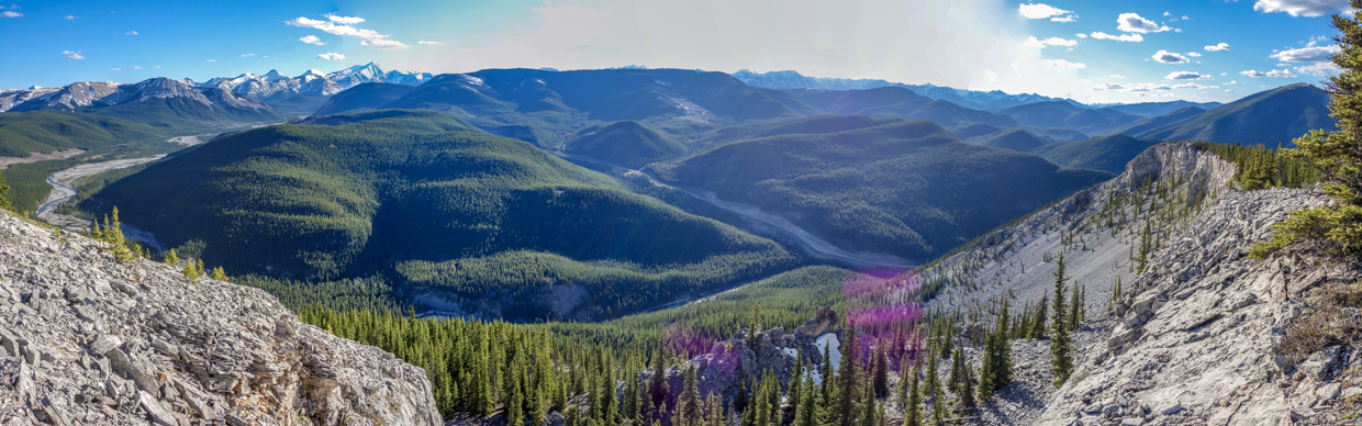
The prairie-filled panorama to the east beyond Swany’s Ridge.
.jpg)
The gorge directly downstream of nearby Elbow Falls. Regrettably, the falls themselves are not visible from ÎÎ’s summit.
.jpg)
Calgary rises up above the surrounding prairies.
.jpg)
In a clearing far below, Matt thought he may have spotted a bear. After zooming in with our cameras, we were surprised to discover that the “bear” in question was a pair of wild horses (and not a boulder as is typically the case)!
.jpg)
The Elbow River winds down the valley from the Big 4, past Forgetmenot Ridge (center left) and around Powderface Ridge (right) and the Mustang Hills (foreground).
.jpg)
A closer look at the Elbow River and its erratic course.
.jpg)
It may be almost June but it’s still winter in the Front Ranges!
.jpg)
Banded Peak (left) and Outlaw Peak (right).
.jpg)
Mounts Cornwall (left background) and Mount Glasgow (left).
.jpg)
Following the usual summit photos and a summit supper, we took a physically distanced group summit photo, packed up and began our lengthy return to the McLean Creek Staging Area.
.jpg)
Rather than reascending Swany’s Ridge, we descended to the Swany’s-ÎÎ col, paid our respects to the moose and started contouring across open hillside towards where we’d originally gained Swany’s south crest.
.jpg)
The beautiful world that’s still out there despite what the COVID-19-obsessed media would have you believe. I still firmly believe that we need to be cautious and responsible but, for the love of God, please stop with the 24-hour news cycle. There’s too much beauty left in this world to focus only on the latest coronavirus speculation. Stay safe, stay well, stay distant and go enjoy the great outdoors! I’m glad that I finally did.
.jpg)
.jpg)
LEFT: Harbinger of spring: the prairie crocus…only, they should have shown up months ago! Better late than never, I suppose!
RIGHT: After some contouring, some hiking and a bit of a mossy thrash, we found our identical bikes exactly where we left them: in the middle of nowhere.
.jpg)
What pushes its bike up a BIG hill gets to white-knuckle ride it back down! I wouldn’t call the ride down the new logging road pleasant but it was certainly efficient! Despite our best efforts to brake, we covered the 3 km (and 230 vertical m) downhill in an impressive 12 minutes. After rejoining the main road, we made our way back to Silvester Creek and realized that the 30 vertical meter ride up its east side wasn’t much compared to the 230 vertical meters we’d biked up earlier! Once we’d cycled up this tiny hill, the route home was all downhill! All-together, we covered the last 9 km of our day in an impressive 30 minutes. Unfortunately, I failed to exceed the posted speed limit (50 km/h) despite my best efforts (48 km/h). Nevertheless, this bike-and-hike thing may need to be repeated!
As I drove back to Calgary after our ascent of Îyarhe Îpan, I watched the sun set over the Rockies in my rear-view mirror. The COVID-19 world may still be filled with fear and uncertainty but damn I’m glad I finally got back out to the Rockies!