Many, many years ago, when I was rekindling my love of the Canadian Rockies in my 20s, two books and one person were my inspiration. The books were Alan Kane’s “Scrambles in the Canadian Rockies” and Craig and Kathy Copeland’s “Don’t Waste Your Time in the Canadian Rockies.” The latter subjectively ranked hikes according to “boots” (akin to stars) and I studied all its premiere “4 booters” keenly. 🥾🥾🥾🥾 Among these, Bow Peak was always near the top of my “to-do” list based on the described “startling sight” of Mount Balfour with its “oozing glaciers” and “meltwater cascades” that “rage across flats to feed Hector Lake.”
In addition to being inspired by guidebooks, I was also inspired by Gord (my Dad even though I rarely give him the pleasure of calling him that 😝). The Old Man was my go-to scrambling partner when I got bit by the peak-bagging bug and I learned a lot about scree-related suffering on our many outings together. Like me, Gord was enthusiastic about “four booters” and, among them, Bow Peak was always at the very top of his list too.
I don’t know why but we never climbed it.
Nearly 20 years passed. I got old. He got older. In 2016, it looked like his scrambling days were over when a hip ailment struck. In 2017, the “old man” had his hip replaced and, as he recovered, he slowly started hiking again. Nevertheless, we were quite certain that he’d never scramble again and Bow Peak’s notorious boulder field and river ford were out of the question.
Still, when my wife suggested that I take my Dad, err, I mean Gord, out for a hike in 2022, I couldn’t get Bow Peak out of my head. Surely, it was a terrible idea for a 74-year-old man with a titanium hip whose biggest hike of the year to-date had been the Ink Pots. 🤨 Still, Gord was intrigued when I mentioned Bow. However, he was also nervous. With justifiable trepidation, he wondered aloud if he could still do it? My answer was “I don’t know but, if not now, when?” Seizing the opportunity, the old man and I set out early on the morning of August 21 with our 4 boots for an overdue adventure on “4 booter” Bow Peak. 🥾🥾🥾🥾
.jpg)
After leaving Calgary at 4:30 am, 🥱 we arrived at the roadside pullout that serves as Bow Peak’s trailhead just as the day’s first rays struck our objective (center). From this pullout, we quickly spotted a trail which descended directly into the woods and we followed it for a minute until it degenerated into a marshy mess. This trail, apparently, works but we abandoned it in favor of the better trail that we knew existed about 300 m south along the highway.
.jpg)
.jpg)
LEFT: After foregoing our date with the bog, we enjoyed great views towards Crowfoot Mountain while we hiked south along the highway.
RIGHT: As anticipated, we found a much drier, firmer trail about 300 m south of our roadside parking spot. Plunging into the forest, we began our adventure!
.jpg)
After 15 minutes of easy hiking, we reached Bow Lake and were greeted by a “four boot” view of Crowfoot Mountain, 🤩 glowing in the early morning sun, with its reflection floating atop the lake’s mirror-like surface.
.jpg)
Of course, reaching the lake meant that we’d also reached the first crux of the day: fording the nascent Bow River at its outlet. 😬 Although I’d forgotten my fording shoes at home, Gord had brought an extra pair which I happily “borrowed!” I guess Dads never stop looking out for their kids!
.jpg)
The Old Man makes quick work of the ford, wisely staying at the very edge of the lake where the current was much weaker. We’d come ready to sink up to our waists but were pleased to discover that the water was “only” knee-deep. Surprisingly, it wasn’t even as cold as the surrounding morning air! 😂
.jpg)
.jpg)
LEFT: After fording the stream, we set off into the woods, following a good trail. In the cool morning air, the woods seemed charming and we hiked eagerly. Morning dew cooled our shins as we brushed past vegetation. Birds chirped. Flowers bloomed. Bees buzzed. 🌲🐦🌻🐝 Breathing deeply, the fresh air powered us as we hiked along in awe of the surrounding wilderness.
RIGHT: One of many lovely, little creeks that cascaded noisily down through the forest.
.jpg)
Gord cautiously crosses a creek on a makeshift bridge comprised of very slippery logs. After fording the Bow River, it seemed a little absurd to risk a slip on these logs but we did nonetheless!
.jpg)
After the “bridged” creek crossing, the trail finally gained elevation and, as we neared tree line, we began to get a sense of how beautiful the alpine pass below Bow Peak (right) would be.
.jpg)
Nearing the pass, several creek crossings were still necessary, however, these were mere trickles and no log-top balancing acts or formidable fords were required.
.jpg)
Gord hikes awestruck 🤩 at the surrounding beauty as the trail grows more and more rocky and rugged.
.jpg)
One of the pass’ cuter residents stops to survey our passing. EEEP!
.jpg)
Just below the pass, a pair of tarns provided, what may have been, the day’s best views. Above, the first tarn’s perfectly still waters mirror BowCrow Peak’s impressive ramparts.
.jpg)
Mere minutes beyond the first tarn, a second tarn may have been prettier still!
.jpg)
.jpg)
LEFT: Crystal Ridge and Cirque Peak rise up beyond the second tarn’s blue depths.
RIGHT: Pinnacles on Bow Peak’s north ridge mirror those of more distant Dolomite Peak; both towered impressively above the first tarn.
.jpg)
Arriving at the pass under overcast skies (click to see larger). Although we’d started out in sunny, somewhat smoky conditions, very little blue sky remained by the time that we reached the broad pass between Bow Peak (left) and BowCrow Peak (right).
.jpg)
Looking south over the beautiful alpine pass towards Mount Temple (distant left), Pulpit Peak (center left foreground), the Preacher (center) and Mount Daly (distant center right).
.jpg)
Gord happily hikes above the pass as nearby Bow Lake comes into view to the north.
.jpg)
Above the pass, Bow Peak ceases to be a pleasant hike and, by most accounts, degenerates into an awful exercise in hopping over unstable boulders. Notably, this boulder-hopping seems to be at its worst directly above the pass (left in the photo above). Hoping to avoid most of the unstable boulders (which could wreak havoc on replaced hips), we elected to follow a steep, somewhat grassy line of ascent diagonally, side-hilling more directly towards the summit which sits well south of the pass (right). As we started up, we wondered if we were in the process of turning, what had been, a thoroughly enjoyable hike into a miserable scramble?
.jpg)
.jpg)
LEFT: Gord starts up the steep, still grassy, slopes with BowCrow Peak looming above. From the pass, the peak looked close but it was actually 500 vertical meters above! Here, photos fail to accurately capture the slope’s angle. It was far steeper than it looks and proved especially cruel given Gord’s age. Hiking up a couple of steps at a time, he stopped frequently and struggled to catch his breath. At one point, I was concerned for his well-being and asked him what his FitBit said his heart rate was? I’d been hoping to get him up Bow Peak but killing him hadn’t been part of the plan!
RIGHT: While we huffed and puffed our way, slowly, slowly up, I spotted four more capable climbers (GOATS! 🐐) high atop a nearby outlier (the one behind Gord in the previous photo).
.jpg)
Eventually, we ran out of grass and our rising diagonal line deposited us near a shallow gully which is sometimes used to descend Bow Peak (rising from the bottom right of this photo). As we caught our breath, Gord and I had a frank discussion about our progress. The top looked close but my GPS indicated that we were still only halfway up from the pass and I wanted to be sure that Gord still wanted to attempt this rubble-fuck before we continued. Committed, he wouldn’t give up. Not yet, anyways. To lessen his burden, I therefore offered to carry his pack and mine for the remainder of the climb.
.jpg)
.jpg)
LEFT and RIGHT: The pack-less Old Man taking the steep scree gully one step at a time. To add some degree of insult to injury, the weather completely deteriorated as we grovelled up the gully. Swirling clouds enveloped the surrounding peaks and it began to pour; we soon found ourselves soaked. 🌧️
.jpg)
HALLELUJAH! After taking 2.5 hours to cover an excruciating 2.0 km distance, we FINALLY reached Bow Peak’s bouldery ridge crest under moody, swirling skies. Of course, a ridge crest is not a summit and the latter was still 0.6 km to the south but, fortunately, only 70 m higher.
.jpg)
About 20 minutes after we gained the rainy ridge crest, Bow Peak’s summit finally came into view (center left) atop a pair of beautiful green cwms and above jewel-like Hector Lake (click to see larger). From here, a 10 minute amble was all that stood between us and our long-sought “four booter.” Of course, this pleasant ridge-top hike was accompanied by the day’s first rumblings from the moody skies above. 😬🤦♂️ As we evaluated the surrounding clouds, we determined that the ominous thunder was from a system which had already blown over. Still, with bank upon bank of gray clouds approaching from the west, we made haste! 🏃♂️
.jpg)
Better late than never! Most scramblers don’t wait until they’re 74-years-old to stand atop beautiful Bow Peak but Gord’s never taken the easy or usual path in life!
.jpg)
A very happy Old Man, finally On Top of Bow Peak. Congrats Grumpo! 🥳
.jpg)
Despite moody, overcast skies and smoky surroundings, the panorama from Bow Peak managed to deliver every one of the “four boots” that were promised. 🥾🥾🥾🥾 Click to see larger.
.jpg)
Nearby Noseeum Peak highlights the view across the Icefields Parkway.
.jpg)
Ephemeral clouds pour forth from Bow Peak’s south ridge. Beyond, Mount Andromache (left), Little Hector (center right) and Mount Hector (right) make for a fine backdrop. Further still, the silhouette of Skoki giants Mounts Douglas and St. Bride can be recognized along the horizon over Hector Pass.
.jpg)
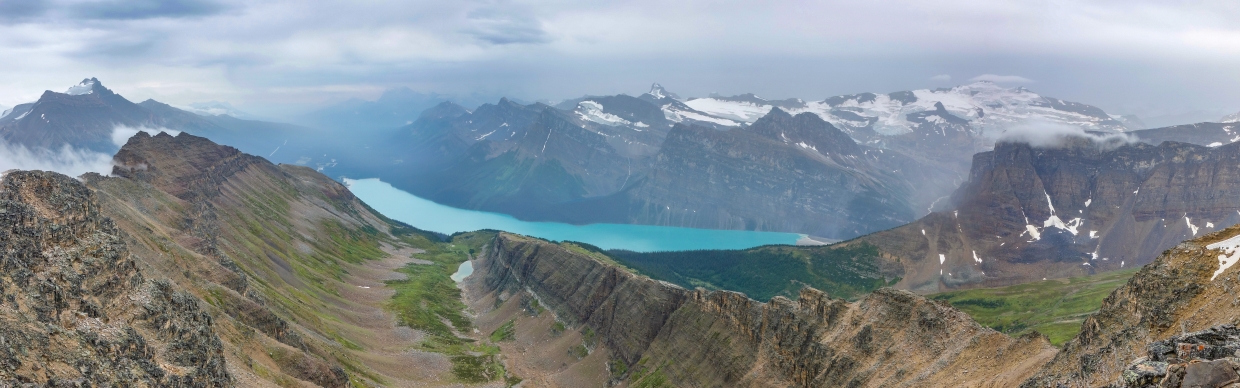
The colorful panorama to the south is dominated by green cirques, aquamarine Hector Lake and the white Waputik icefield above them both. Click to see larger.
.jpg)
A closer look at glaciated Mount Hector.
.jpg)
Glacier-fed Hector Lake is scarcely visible from the Icefields Parkway but its magnificence is on full display from the summit of Bow Peak!
.jpg)
.jpg)
LEFT: Where once a glacier rested, only carved and colorful features remain to the south.
RIGHT: Unseen Turquoise Lake drains into tiny Lake Margaret via a great cascade. Below, and more colorful still, Hector Lake continues to dominate the scene. Above, remnant glaciers cling to the steep north faces of the Preacher (center) and hornlike Mount Daly (right).
.jpg)
While the southward scene was undeniably impressive, no sight in that direction could match that of Mount Balfour’s monstrously glaciated east face.
.jpg)
A moody mountain panorama to the north (from whence we came). Click to see larger.
.jpg)
The Icefields Parkways snakes its way towards Jasper below a host of semi-seen giants.
.jpg)
Blue-green Bow Lake and the red-roofed Num-Ti-Jah Lodge briefly reveal themselves below the parting clouds.
.jpg)
Colorful peaks and verdant valleys to the north. From left to right: Mount Jimmy Simpson, Mount Patterson, Mount Chephren, Mount Weed, Observation Peak, Cirque Peak and Dolomite Peak.
.jpg)
Nearby Dolomite Peak’s serrated towers pierce the valley’s low-lying clouds.
.jpg)
Ecstatic that all four of our boots made it up this “four booter!”
.jpg)
.jpg)
LEFT: The rather impressive, if not precarious, “tripod” that captured the above summit shot of Gord and I. 😂
RIGHT: The Old Man’s feat recorded for posterity in the annals of Bow Peak’s impressive summit cairn.
.jpg)
While it had taken us decades to finally stand atop Bow Peak together, Gord and I didn’t allow ourselves the luxury of a long summit stay. With more wet weather on its way, we spent a mere 10 minutes taking pictures on top and then beat a hasty retreat!
.jpg)
Fortunately, we reached the scree gully that we’d grovelled up just as the worst of the next storm hit. 🌧️
.jpg)
.jpg)
LEFT: Under a driving rain, Gord cautiously descends ledges in the upper gully. At least, there was no thunder (which would have made our descent a little less cautious)! 🏃♂️
RIGHT: Having had enough side-hilling on our scramble up, we decided to follow the gully straight down to its base this time. Lower down, the rubble and scree gave way to a steep, muddy slip-and-slide which allowed for a quick (if not always pretty) descent.
.jpg)
At the base of the gully a significant boulder-field still stood between us and the pass. Despite appearances, however, there was a reasonable path (marked with cairns) through this mess. To our great surprise, only a few, brief sections of acrobatic boulder-balancing proved necessary! 🙏
.jpg)
Having rushed our summit stay and descent to avoid the potential for meteorological “zap-boom,” 🌩️ we breathed sighs of relief upon reaching the scenic pass and finally stopped to enjoy our lunches. Unfortunately, the rain had soaked through all my layers and this stop resulted in my core temperature plummeting. I was keen to enjoy this view and a sandwich but my inability to stop shivering 🥶 made this stop relatively brief as well!
.jpg)
On the road again… (and starting to warm up again)
.jpg)
.jpg)
LEFT: As we descended, the clouds, once again, rushed up-valley, obscuring nearby BowCrow Peak (at the same time that they highlighted the precariously pointy outlier we’d spotted the goats upon earlier).
RIGHT: Yet another wildlife close encounter. I nearly stepped on this ptarmigan (1 of 13 which we saw just below the pass 🤯)!
.jpg)
.jpg)
LEFT and RIGHT: Beautiful views of Dolomite Peak and Mount Chephren, respectively, as we made our way down from verdant alpine meadows into lush subalpine forests.
.jpg)
.jpg)
LEFT: Of course, the hike through the forest proved much less charming than it had been earlier in the day under sunny skies!
RIGHT: As the trail neared the fledgling Bow River again, we eagerly anticipated the nearby ford (which was the last difficulty standing between us and the cooler a craft beer in our trunk)!
.jpg)
Braving Bow Lake’s icy waters again, we carefully made our way across to its east bank (stopping only for a picture or two)! With views like these, who could resist reaching for their cameras? Besides, the glacial waters actually felt good on our throbbing feet! 😂
.jpg)
Thanks to the day’s cool temperatures, the ford proved no deeper in the late afternoon than it had in the early morning. If you climb Bow Peak on a hot day, however, you may need to be aware of rising water levels due to melt from the nearby Wapta Icefield. “Luckily” for us, this was not an issue as we shivered our way back across!
.jpg)
The Old Man finishes the day in style! About 15 minutes after our second ford of the day, we found ourselves back at the roadside pullout where this overdue adventure concluded with a pair of cold beers 10.5 hours after it began. Sated with Gord’s accomplishment and our cold suds, we peeled our 4 wet boots off, put our feet up and cheered to Bow Peak – a surefire “four booter” (rain or shine)! 🍺🥾🥾🥾🥾🍺
.jpg)
.jpg)
.jpg)
.jpg)
.jpg)