Little Arethusa
Elevation: 2768 m
Elevation Gain: 620 m
Little Arethusa is a scenic outlier of Mount Arethusa. Part of the Misty Range, Mount Arethusa was named for the British light cruiser Arethusa. The HMS Arethusa was sunk by a mine in 1916 and the peak was named in her honor in 1917. While the route up Mount Arethusa involves difficult scrambling, the hike up Little Arethusa is much less technical.
My Ascents:
September 13 2014
Trailhead: Arethusa Cirque Parking (Roadside)
GPS Track: Little Arethusa
Following a significant and unseasonably early snowfall which wreaked havoc across much of southern Alberta, scrambling options in the Canadian Rockies were somewhat limited. Indeed, my options were even further limited by the need to be back in Calgary by 5:00 pm to catch the Stampeders – Argos game. Wanting to use my available time wisely and make the most of the (suddenly) wintery scenery, I decided on a short, non-technical objective in one of the areas hardest hit by “Snowmageddon” 2014: Highwood Pass.
.jpg)
Little Arethusa (left) has been on my list of “peaks to climb in snowy conditions” ever since Brianne and I climbed nearby Mount Arethusa (right) a couple of years ago. While I had always envisioned climbing this peak in snowy conditions, I hadn’t anticipated doing so with 2 weeks of summer still remaining on the calendar!
.jpg)
With sub-zero temperatures at the trailhead, the crisp air provided clear views of the moon over Highwood Ridge.
.jpg)
Looks like it even snowed on the moon! Quite the early September storm, that was…
.jpg)
Crux wonders what happened to summer as we attempt to follow the faint Little Arethusa trail through ankle to knee-deep fresh snow.
.jpg)
Working our way up the right-hand side of a creek towards Arethusa Cirque.
.jpg)
Crux makes his way across the chilly creek as the trees begin to thin.
.jpg)
After crossing the creek, we worked our way towards Little Arethusa (climber’s left). Using an open hillside to gain elevation, we quickly left the cool shade of the forest behind in favor of the still warm summer sun.
.jpg)
"Hooray it's winter!" Crux trots about gleefully in the fresh powder.
.jpg)
Upon reaching Arethusa Cirque, the routes for Little Arethusa (left) and Mount Arethusa (right) split.
.jpg)
Crux takes a break as we work our way up Little Arethusa’s southeast ridge. He had forgotten how hard breaking trail is!
.jpg)
Clouds brew atop Storm Mountain as the terrain steepens.
.jpg)
Crux loves kicking steps up steep snow! This may seriously be the happiest dog you'll ever see.
.jpg)
Near the summit, the terrain begins to level off and the ridge becomes a little sharper. If you stick to the ridge crest, there is some very minor exposure, however, this can all be avoided to one side of the ridge or the other.
.jpg)
About 2.5 hours after leaving the car, we reached the summit (complete with cairn and large orange boulder).
.jpg)
Storm Mountain (left) and Highwood Ridge (right) are the highlights of the panorama from the summit. Crux was duly impressed. Click to see larger.
.jpg)
Looking along Little Arethusa’s ascent ridge (our tracks/paw prints are visible just to the right of the ridge crest) towards the beautifully folded rocks that make up Storm Mountain.
.jpg)
The steep snowy summit of Storm Mountain barely visible through wispy clouds.
.jpg)
Misty Range panorama – from left to right: Mount Rae, Mount Arethusa and Storm Mountain. Snowy Arethusa Cirque lies far below the steep north face of Little Arethusa. Click to see larger.
.jpg)
Crux enjoys his summit stay as the sun illuminates larger Mount Arethusa.
.jpg)
Looking north along the knife-edge ridge connecting Little Arethusa to Mount Arethusa (right). Beyond, King’s Ridge connects Arethusa to massive Mount Rae.
.jpg)
The lofty summit of Mount Rae beyond a large gendarme. At 3218 m, Mount Rae is the highest peak visible from Calgary.
.jpg)
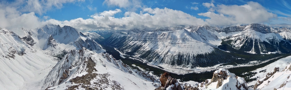
Despite the relatively small effort required to ascend Little Arethusa, there’s nothing “little” about the view from the top! From left to right: Mount Arethusa, Storm Mountain, Mount Lipsett, Highwood Ridge (above the Highwood Pass parking area), Grizzly Ridge, Mount Tyrwhitt (in the clouds), Pocaterra Ridge and Mount Pocaterra. Click to see larger.
.jpg)
Highway 40 winds its way along the base of Highwood Ridge towards Mount Lipsett. Beyond, Mount Storelk and the Elk Range are partially obscured by cloud.
.jpg)
From the summit, it’s a sheer drop to Ptarmigan Cirque several hundred meters below. Definitely a good idea to mind your step up here when it's slippery!
.jpg)
Looking beyond snowy Pocaterra Ridge and rocky Mount Pocaterra towards the larger peaks of the continental divide.
.jpg)
Pocaterra Cirque at the base of the long ridge connecting Mounts Tyrwhitt (left) and Pocaterra (right) across the highway.
.jpg)
Scattered clouds break up the view of Mounts Joffre, Petain and Fox.
.jpg)
Posing for a quick photo with Storm Mountain before beginning our descent and racing back to Calgary for the Stamps game!
.jpg)
Making use of the available terrain features, we were able to plunge step quickly all the way back down to the tree line. Crux had snow much fun running down the entire southeast ridge!
.jpg)
Final views of Storm Mountain as the clouds lift.
.jpg)
Arethusa Cirque’s larches are just beginning to show their golden autumn color (autumn is the season between summer and winter…or so I’ve heard).
.jpg)
After plunge stepping down the mountain, we retraced our steps across the chilly creek and made our way quickly back through the forest to our waiting car. Despite only taking 4 hours (with a lengthy summit stay), Little Arethusa was a stunning little peak that was perfect for a wintery September day. The only thing that could rival the spectacular summit scenery was the spectacular 40-33 Stampeders come-from-behind win later that evening! Go Stamps go!
.jpg)
.jpg)
.jpg)