One June 12, I set out from Calgary with my Toyota Highlander loaded up to the roof for a family camping trip on Vancouver Island. Not wanting to drive the entire 1,300 km to Tofino with a toddler, it was decided that I’d drive out a day ahead of Brianne and Mera (who would follow by air). Despite the incredibly simple directions to reach my destination (follow Highway 1 west until the Pacific ocean), I still somehow managed to make a wrong turn and, somehow, ended up on top of a mountain! Oops!
All kidding aside, my ascent of Whitehorn was quite deliberate. Although the drive ahead promised to be long, it seemed a shame to drive through the Rocky Mountains without stopping to climb one of them. I reasoned that Whitehorn would be a good target since the summer sightseeing gondola could whisk me up the peak’s first 500 vertical meters. From there, I figured that I could tackle the mountain’s top half rather quickly using a myriad of ski runs. I then hoped to take advantage of early summer snow to expedite my descent with a refreshing glissade. In the end, my plan came together beautifully as I was able to bag a peak under sunny skies while only adding 3.5 hours to my lengthy day!
.jpg)
Whitehorn Mountain (left) as seen from the base of the Lake Louise ski resort. The speedy gondola is not only an asset to hikers and sightseers but actually a necessity as the bottom half of Whitehorn is subject to a Park’s area closure. Parks will tell you that this area closure is designed to keep people away from the area’s many grizzlies but the skeptic in me wonders if it might have more to do with drumming up business for the resort. If the grizzlies are so sensitive to humans, why allow summer resort operations (which bring thousands of tourists) at all? Alas, on this day I didn’t really care as the gondola suited my “need for speed” so I paid my $36 fare and enjoyed my leisurely “approach.”
.jpg)
Climb smarter not harder!
.jpg)
A mother grizzly and her cubs cool off underneath the sightseeing gondola. While the area closure kept them away from tourists in the morning, it did little to help in the afternoon when they were the focal point of a “bear jam” on the road down from the resort.
.jpg)
From the upper gondola terminal, hiking is accessed by passing through an overstated electric fence. I understand the reasoning behind this contraption but, having hiked in close proximity to bears without incident for decades, it still strikes me as somewhat comical.
.jpg)
After following the “Kicking Horse Viewpoint” trail (really a summer access road for the ski hill) for 10 minutes, I reached the “Summit Platter” lift and veered to the climber’s right, making my way up the path ski run of least resistance.
.jpg)
A wild Ski-Doo in its native habitat. Fortunately, the top half of Whitehorn isn’t subject to a protective closure for these rare Rockies residents!
.jpg)
Upon reaching tree line, the rounded (but steep) summit of Whitehorn is obvious and route finding is as simple as following your nose.
.jpg)
A compelling demonstration of snow fence effectiveness. The “Top of the World” and “Paradise” lifts can be seen beyond the fence on Whitehorn’s false summit. The true summit resides out of sight to the left of this photo.
.jpg)
A snowy hike up alongside the “Summit Platter.”
.jpg)
The top of the “Summit Platter” marks the end of the intrusive ski hill infrastructure. From here, the 30 m higher summit resides 150 (lift-free) meters to the northwest.
.jpg)
Just when I thought I’d found the perfect place to relieve myself…
.jpg)
A broad arête leads to Whitehorn’s spectacular 2637 m-high summit. While the snowy ridge was quite tame, it allowed me to pretend that my easy hike was an alpine adventure.
.jpg)
Told you that the summit view was spectacular!
.jpg)
The Continental Divide’s glacier-capped peaks highlight the summit panorama across the Bow Valley. Click to see larger.
.jpg)
Kootenay National Park giants (from left to right): Storm Mountain, Mount Ball and Stanley Peak.
.jpg)
Panorama Ridge, Bident Mountain, Quadra Mountain, Mount Babel and Mount Fay highlight the view towards the Valley of the Ten Peaks.
.jpg)
Massive Mount Temple. “The majesty!”
.jpg)
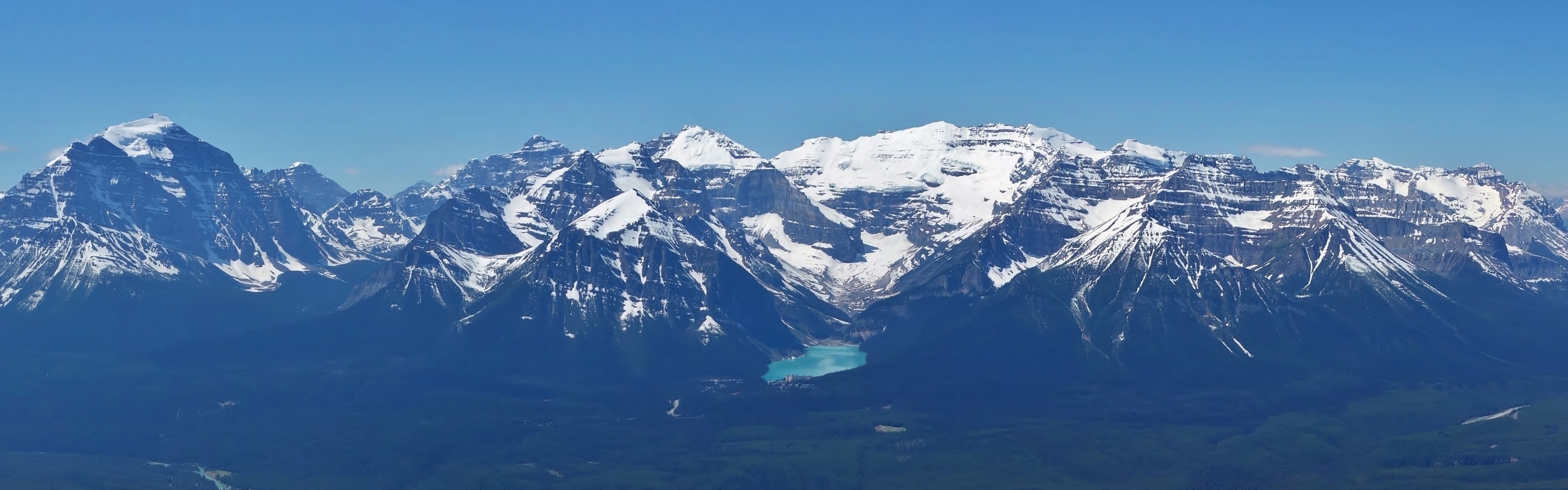
The Lake Louise group (from left to right): Mount Hungabee, Haddo Peak, Fairview Mountain (foreground), Mount Aberdeen, Mount Lefroy, Mount Victoria, Collier Peak and Mount Whyte.
.jpg)
The “Jewel of the Canadian Rockies.”
.jpg)
A closer look at beautiful Mount Victoria and the "Death Trap" at its base.
.jpg)
Peaks-a-plenty! From left to right: Pope’s Peak, Mount St. Piran (foreground), Mount Niblock, Narao Peak, Cathedral Mountain, Mount Stephen and Divide Peak (foreground).
.jpg)
The TransCanada Highway crests Kicking Horse Pass and continues into BC. In an hour or so, I’ll be doing the same!
.jpg)
Yoho National Park Giants: The President, The Vice President, Mount Niles, Kiwitenok Peak, Mount Daly and Waputik Peak (foreground).
.jpg)
Mounts Balfour (left), Gordon and Olive (right) preside over the Wapta Icefield.
.jpg)
Mount Hector guards the southern end of the Icefields Parkway.
.jpg)
The panorama to the east was equally awesome. Click to see larger.
.jpg)
Mount Willingdon rises up beyond Molar Mountain.
.jpg)
Mount Richardson.
.jpg)
Skoki landmarks to the northeast: Pika Peak, unnamed, Ptarmigan Peak, Fossil Mountain and Mount Douglas.
.jpg)
Mount St. Bride beyond Boulder Pass.
.jpg)
A summit selfie with Mount Douglas, Mount St. Bride and Redoubt Mountain.
.jpg)
MORE mountains! I realize that the number of summit shots in this trip report now borders on ridiculous but I simply couldn’t help myself! From left to right: Mount Avens, Pulsatilla Mountain, Bulwark Peak, Armor Peak and Protection Mountain.
.jpg)
Even Mount Assiniboine made an appearance to the right of Lipalian Mountain on this clear June day.
.jpg)
A final panorama towards the Valley of the Ten Peaks, Paradise Valley and the Louise Group before resuming my long journey to Vancouver Island. Click to see larger.
.jpg)
My descent was easy on the eyes thanks to views like this!
.jpg)
Looking down towards the Whitehorn Lodge: a beautiful spot to say “I do”!
.jpg)
A “black diamond” glissade! I’d hoped to glissade most of my descent but this run (#22 Headwall) proved to be more than I bargained for. I initially chickened out and tried to kick steps down the steep slope before slipping in the slush and involuntarily glissading anyways. Thankfully, I was able to arrest with my axe. Once my slide was under control, I figured there was no point stopping and proceeded to set a landspeed record in the “bum slide” category!
.jpg)
The day’s crux: elbowing my way to the front of the line for gondolas back down to the base.
.jpg)
Seriously enjoying my deproach!
.jpg)
About 45 minutes after I left the summit, I reached the ski hill’s scenic base, bought a Coke and resumed my long journey to the Pacific. Despite the fact that I still had about 14 hours of driving ahead of me, I had no regrets about my “wrong turn” in Lake Louise!
.jpg)
.jpg)
.jpg)