Winter is coming.
These three ominous words, popularized by fantasy drama Game of Thrones, strike fear into the hearts of Canadian outdoor enthusiasts and Westeros’ fictional residents alike. As September waned, I felt like I was standing over a great precipice. Below me, and imminent, the prospect of another long, cold winter. 2020 has been an awful year for many reasons but, in these parts, it served up a spectacular summer; a summer filled with camping trips, family hikes and summits. I wasn’t ready to bid these cherished seasonal pursuits adieu. So, with unusually warm and sunny autumn weather forecast, I decided to “treat myself” to one last big day in the mountains. After all, at this time of year, one never knows how many nice days there are left…
Having been awed by Matt Clay’s recent larch-filled photos, I decided to follow in his footsteps and attempt Skoki Mountain as a long daytrip. Skoki Mountain is a somewhat diminutive peak. With a mere 482 m prominence, it isn’t exactly a coveted summit and few would consider it worthy of the effort required to complete a 34 km daytrip. But, as is often said, the journey is more important than the destination. In this instance, my summit destination provided a thinly veiled excuse to enjoy the long hike, over alpine passes and by larch-lined lakes, hopefully culminating with another “tick” in the index of my well-worn copy of “Scrambles in the Canadian Rockies.”
After a night spent tossing and turning in alpine anticipation, I left Calgary in the morning’s wee hours and arrived at the trailhead around 7 am.
.jpg)
.jpg)
LEFT: Having hiked up the Temple fire road many times, I switched things up a little and employed an alternate conveyance to cover the day’s first (and, more importantly, last) 4 km.
RIGHT: A vibrant sunrise provided inspiration as I huffed and puffed my way up the fire road on my two-wheeled steed.
.jpg)
The massive peaks of the Lake Louise group glow under the day’s first rays. Occasional views like this provided a welcome excuse to get off the bike (and attempt to catch my breath)!
.jpg)
.jpg)
LEFT: Moody skies and a cloud-capped Mount Victoria call into question Environment Canada’s “clear and sunny” forecast…
RIGHT: 4 km from the trailhead, I reached the Parks kiosk that denotes the end of the road for cyclists. After stashing my bike in the woods, I took advantage of the picnic table here to enjoy some tea (“Earl Grey – Hot”) and a much-needed rest. The decision to cycle the Temple fire road was intended to expedite my exit later in the day but I was surprised at how physically taxing the ride up was! By the time that I reached this point, I found myself shaky from overexertion (a worrying sign when you still have 30 km left to cover).
.jpg)
Shaky or not, the trail wasn’t going to hike itself, so I gulped my tea and set off. After a couple of kilometers in the woods, I reached more alpine environs and was treated to views of scattered larch trees as Mount Richardson, Pika Peak and Ptarmigan Peak swirled in and out of the, un-forecast, clouds above.
.jpg)
About 7.5 km from the trailhead, I reached the Skoki Halfway Hut and sarcastically remarked that it was going to be more of a “Quarter-Way Hut” for me today. Since there was no one but myself and larch trees around, the joke landed with a metaphorical thud. Still, I felt quite clever despite the trees’ having no sense of humor.
.jpg)
Boulder Pass appears beyond the “Quarter-Way Hut.” This would be the first of four passes that I’d need to go up and over to tackle Skoki Mountain as a daytrip. When I write that out, I begin to wonder what part of me thought this was a good idea for a one-day outing…
.jpg)
Arriving at Boulder Pass for the umpteenth time, I was reminded that it is both scenic and aptly named.
.jpg)
Beyond the pass, the trail wound its way along Ptarmigan Lake’s scenic shoreline towards Packer’s Pass Peak (center) and Fossil Mountain (center right).
.jpg)
.jpg)
LEFT: Massive Mount St. Bride looms above the lake on a moody morning.
RIGHT: Having rounded the lake, I looked back to enjoy the view of Redoubt Mountain’s ramparts which towered above profuse pasqueflowers.
.jpg)
After spotting a cairn, I left the lakeside trail and meandered up open terrain towards Packer’s Pass (center left) and its namesake peak (center). The official trail to Skoki Lodge/Mountain breaches Deception Pass (which can be seen on the center right between Packer’s Pass Peak and Fossil Mountain). Packer’s Pass was so-named because it provided a shorter, but more rugged route, for porters carrying supplies to the lodge before helicopters rendered them obsolete. On this day, I decided to hike into Skoki via Packer’s Pass mainly because this route passes by the uber-scenic Skoki Lakes (Zigadenus and Myositis). The fact that this route made my, already long, day a little shorter was also appreciated!
.jpg)
.jpg)
LEFT: As I hiked up towards the second pass of my day, I was startled when a majestic stag emerged from the krumholtz nearby. While this fellow’s sudden appearance sent adrenaline coursing through my veins, I was relieved that my wildlife run-in wasn’t with a more predatory mammal.
RIGHT: A closer look at “the Great Prince of the Forest.”
.jpg)
After cresting Packer’s Pass, I was treated to one of the breathtaking views that inspired this “little” adventure: Zigadenus Lake’s vibrant blue waters surrounded by a sea of golden fall color (all below the impressive Wall of Jericho)!
.jpg)
Following a decent trail down from Packer’s Pass, the sun’s rays warmed me and set the larch trees all about, metaphorically, aflame.
.jpg)
What’s better than one spectacular glacial lake surrounded by golden larch trees? How about two?! As anticipated, I found myself awestruck by the splendor of Zigadenus Lake (left) and Myositis Lake (right). This amazing view was the main reason that I’d come so everything beyond this point was simply a bonus! Click to see larger.
.jpg)
.jpg)
LEFT: Retreating glaciers, their remnant moraines and the impressive Wall of Jericho made for a fine backdrop to Zigadenus Lake. While golden grasses still made for nice fall colors here, the larch trees were, sadly, past their prime.
RIGHT: The more sheltered environs of Myositis Lake, however, proved to be a refuge for the golden larches that I sought!
.jpg)
Larches, lakes and sunshine. Life is good!
.jpg)
After following the cairned trail down the headwall which separated the lakes, I was treated to a wondrous panorama from Myositis Lake’s shores. This vantage also granted me a first good look at Skoki Mountain (center), which still looked disturbingly far despite having hiked 13 km over 2 passes already! Click to see larger.
.jpg)
As I rounded Myositis Lake’s shoreline, Ptarmigan Peak (left) and the Wall of Jericho (right) filled the panorama behind me, inspiring a number of photography breaks. Click to see larger.
.jpg)
.jpg)
LEFT: Below Ptarmigan Peak’s glacier-clad north face, fallen larch needles make Myositis’ already colorful shore even more-so.
RIGHT: More Myositis!
.jpg)
.jpg)
LEFT: Having rounded Myositis Lake’s shores, I reached its outlet stream which cascaded down an impressive headwall towards larch-laden meadows and more distant Skoki Mountain below.
RIGHT: Despite the headwall’s fearsome appearance, a well-cairned, easy route led to the meadows below. The route started near the lake’s outlet waterfall, descended a small ledge, passed under a chockstone and then followed rock steps down a chimney.
.jpg)
After bidding farewell to the lakes, amazing alpine views back towards Ptarmigan Peak continued to slow my progress towards Skoki Mountain.
.jpg)
.jpg)
LEFT: After some pleasant meadow hiking, the trail eventually entered more dense forest which shrouded the view and numbed the mind. As I neared Skoki Lodge, I literally reached a “fork in the road” and followed the main path towards the historical backcountry edifice.
RIGHT: An official Federal Government plaque describes the lodge’s historic significance.
.jpg)
As I passed by, I noted that Skoki Lodge looked like a pleasant place to while away some time. Perhaps, I should allow myself more than a single day for my next trip into this valley?...
.jpg)
Behind the lodge, I quickly located a signed trail towards my objective and continued upwards as I wondered (somewhat scared to ask) “what the hell is a ‘peepipe’?!” 😬
.jpg)
.jpg)
LEFT: The well-trodden trail from Skoki Lodge to Skoki Mountain. The peak would be a delightfully short trip from the lodge. From the Fish Creek trailhead, perhaps less-so!
RIGHT: After ascending through thinning forest, the trail entered a gully, above which Skoki Mountain finally reappeared. From here, the route contoured to the climber’s left following gentler terrain towards the peak’s northwest ridge.
.jpg)
As the day pressed on, it became abundantly clear that Environment Canada’s “clear and sunny” weather forecast had been a work of fiction. Fortunately, moody skies presented opportunities for interesting photography as well. As I hiked above the tree line (yet again), I was treated to this colorful view of a rainbow over Molar Mountain and the pot of golden larches at its terminus below.
.jpg)
Slog mode – Engage! (Despite appearances, there was actually a decent trail carved into this treadmill slope.)
.jpg)
.jpg)
LEFT: Abundant fossils litter Skoki Mountain’s upper slopes. Once could spend hours hunting for paleontological treasures up here but, with only the luxury of a quick in-and-out daytrip, I resigned myself to passing the fossils by as I continued to churn ever upwards.
RIGHT: An ephemeral ray of sunshine lights up the now-distant-looking larches surrounding Zigadenus and Myositis Lake as I climb.
.jpg)
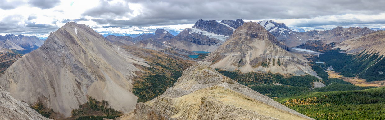
After rounding Skoki Mountain’s west facing scree slopes, I gained its northwest ridge. Despite a windy barrage, this ridge was followed easily to the peak’s summit. The day was neither warm nor sunny as promised but, as you’ll see, it did live up to its scenic advertising…
.jpg)
A summit panorama worth slogging 17.5 km and over 2 passes for! Larches and lakes fill the alpine valleys below while peaks and glaciers flirt with, un-forecast, clouds above. “Skoki” may literally translate to “swamp” but it truly is a gem! Click to see larger.
.jpg)
Immediately south, Fossil Mountain’s rocky slopes are surrounded by larch forests and alpine meadows. When I scrambled up it in 2012, I really had no idea what I was getting into (but I’m glad I did). Someday, I’ll have to return (if I can convince my favorite hiking partner to join me atop it again).
.jpg)
A pair of passes sit below Fossil’s west face (Deception on the left; Packer’s on the right). On my hike in, I passed over Packer’s Pass. As I sat atop Skoki Mountain, however, Deception Pass’ more gentle slopes started to look appealing for my hike back out (despite the longer distance required). 🤔
.jpg)
Heather Ridge rises up above Deception Pass. Further still, Storm Mountain, Mount Ball, Stanley Peak, Mount Verendyre, Boom Mountain and Mount Whymper are also visible.
.jpg)
Unity Peak, Purple Mound and Redoubt Mountain rise up above diminutive Packer’s Pass Peak. To the left, distant peaks include: Mount Bell and Foster Peak. To the right, far-away Mounts Fay, Babel and Little are also recognizable.
.jpg)
The nearby Wall of Jericho separates Zigadenus and Myositis Lakes (left) from Merlin and Castilleja Lakes (right). Beyond the lakes, the glaciers from which they originate cling to the north faces of Ptarmigan Peak, Pika Peak and Mount Richardson.
.jpg)
.jpg)
LEFT: A closer look at Ptarmigan Peak and the spectacular Skoki Lakes below it.
RIGHT: Larch forests surround Merlin Lake and Castilleja Lake at the foot of Merlin Castle while Mount Stephen rises up beyond a high pass.
.jpg)
The panorama to the north is dominated by the intersection of the Skoki (left), Pipestone (center) and Red Deer River Valleys. Click to see larger.
.jpg)
Mount Richardson’s spectacular north face.
.jpg)
To the northwest, a host of Icefields Parkway peaks are visible up the Pipestone River Valley.
.jpg)
Nearby Mount Hector (left) plays shy in the clouds while smaller neighboring peaks like Mount Andromache (center right) and Dolomite Peak remain visible below the low ceiling.
.jpg)
Directly to the north, Cyclone Mountain (left) and Pipestone Mountain (right) backdrop the nascent Red Deer River.
.jpg)
Red Deer Lakes: the source of the mighty Red Deer River.
.jpg)
The beginnings of the Red Deer River (left) and my marriage (right) highlight the panorama to the east. Click to see larger.
.jpg)
Massive Mount Drummond (left) presides over the Red Deer River as it winds its way east towards the Ya Ha Tinda front ranges.
.jpg)
Mount Douglas and Mount St. Bride tower above nearby Oyster Peak and are, easily, the most impressive peaks to the east of Skoki Mountain.
.jpg)
A closer look at Mount Douglas…
.jpg)
… and its glacier-carved neighbor: Mount St. Bride.
.jpg)
Lychnis Mountain (left) and tiny Tilted Mountain (center right) highlight the view beyond, yet another, larch-filled valley.
.jpg)
Snapping a quick summit selfie with the always-photogenic Skoki Lakes.
.jpg)
.jpg)
LEFT: Documenting a summit oddity before starting the LONG hike home. While Skoki Mountain’s slopes are littered with fossil shells, its rosy summit conch shell is, indisputably, out of place. There must be a story behind its presence…
RIGHT: After enjoying a windy summit stay, I started back down, electing to follow a decent scree run on the peak’s west face rather than retracing my steps along its northwest ridge.
.jpg)
Making my way back by historic Skoki Lodge.
.jpg)
.jpg)
LEFT: A rushing stream by the lodge proved to be a godsend for me as I uncharacteristically exhausted my water supply on the long hike up to Skoki Mountain.
RIGHT: With my energy levels waning somewhat, and a LONG way to go yet, I opted to hike out via Deception Pass to spare myself from the steep up-hills above Skoki Lakes.
.jpg)
In addition to its gentler slopes, the hike up Deception Pass provided me with a new perspective from which to admire Zigadenus Lake and Myositis Lake!
.jpg)
Golden larches contrast with the monochromatic hues of rock and ice beyond.
.jpg)
Following the well-trodden trail that leads to Deceptions Pass, east of Packer’s Pass Peak.
.jpg)
A pair of hikers enjoy the area’s autumn colors from atop Packer’s Pass Peak.
.jpg)
Continued amazing views provide a much-needed excuse to stop. As I hiked 300 vertical m back up Deception Pass, my various aches and a general sense of exhaustion were a testament to the distance I’d already travelled, making me somewhat weary that I was still hiking up (and not down) at this point in the day!
.jpg)
At last! Deception Pass comes into view! 🙏
.jpg)
One final glance back towards a sunny Skoki Mountain as I crest the pass. From here on, the 11 km journey back to the car would, at least, be downhill!
.jpg)
Looking south from Deception towards my next pass: Boulder (right). As the kms ticked by, the area continued to deliver on the scenic promise that had brought me here (even if I was getting too tired to fully appreciate it). From left to right: Brachiopod Mountain, Anthozoan Mountain, Heather Ridge and Redoubt Mountain above Ptarmigan Lake. Click to see larger.
.jpg)
After a scenic hike back alongside Ptarmigan Lake (where photography was kept to a minimum in the interest of GTFD’ing), I was greeted by the familiar monoliths at Boulder Pass.
.jpg)
Larches light up the landscape between Boulder Pass and Richardson Ridge. Click to see larger.
.jpg)
Shining in the late afternoon light, Mount Temple towers above colorful larch forests and the cataclysmic rockfall that formed Boulder Pass. It was at this point that, for the first time in many hours, I could finally see where I needed to get down to (the Bow Valley below).
.jpg)
.jpg)
LEFT: After leaving the scenic larch forest behind, I grew weary as I continued to plod down, down, down through the viewless stretch that separates the “Quarter-Way Hut” from the Lake Louise Ski Resort. It is, however, always darkest right before the dawn and I was comforted by the knowledge that, this time around, the shelter was more of a “Three-Quarter-Way Hut!” Better still, I knew that the day’s final 4 km fire road exit would be speedy thanks to the bike that I exhausted myself riding up in the morning!
RIGHT: Presto! Fini! After a long day of putting one boot in front of the other, I reached my bike and tore down the fire road in only 9 minutes!
Winter may be coming but fall is still here. With the larches still golden, the sapphire lakes still liquid and the trails still snow-free, I’m glad that I took full (34 km!) advantage and “treated myself” to one last big day this year. My feet may be sore. My legs may be tired. But I am refreshed!
.jpg)
.jpg)
.jpg)
.jpg)
.jpg)
.jpg)
.jpg)
.jpg)