After pushing myself a little with a solo ascent of Mount Bogart the day prior, I decided that some company would be nice on another hot and clear day in the Rockies. Although my mom had originally suggested Mount St. Piran as an objective, I was weary about ascending this peak for the 7th time so I countered with the suggestion of Mount Indefatigable’s south summit which none of us had visited in years. While the south summit is marginally (15 m) lower than the true north summit, it actually offers improved views since it is closer to Upper Kananaskis Lake and the large surrounding peaks of the continental divide. As an added bonus (for those who prefer to avoid scrambly bits), the south summit is largely a walk-up with only a few short meters of easy scrambling required at the top.
.jpg)
Mount Sarrail (left), Warrior Mountain (distant center) and Mount Lyautey (right) are beautifully reflected in the calm waters of Upper Kananaskis Lake on a clear and HOT morning. With views like this a few meters from the “Interlakes” parking lot, we knew that we were in for another awesome day!
.jpg)
Grassy slopes lead to the rocky south summit of Mount Indefatigable (far right) on the north shore of Upper Kananaskis Lake.
.jpg)
Shortly after crossing a dam, we found the trailhead of the (formerly official) Indefatigable trail. While the trail used to be maintained, it has since been relegated to the status of “unofficial” (and, therefore, unmaintained) in an effort to limit the number of human visitors to the prime grizzly bear territory that makes up Indefatigable’s east-facing slopes. Based on the number of hikers, scramblers and climbers that we ran into, I’d say this trail “closure” (and the large bear sign) have done little to deter anyone.
.jpg)
The hike starts on a good trail which ascends in the forest to the climber’s left of this rock rib. Wanting a little extra challenge, however, mom opted to tackle the slabby rib head on (swearing and sweating the whole way).
.jpg)
The sun beat down upon us mercilessly forcing frequent breaks. Fortunately, these provided the opportunity to stop and enjoy the wonderful views behind us.
.jpg)
EXSTATIC to find some shade. As the temperature began to push 32 degrees Celsius, even the smallest patch of shade became a cause for celebration (and another break)!
.jpg)
Crux especially enjoyed the shade (and the numerous bowls of water that accompanied every break in it).
.jpg)
Above the tree line, a pristine alpine tarn is revealed below the north summit of Indefatigable (left) and its outlier (right).
.jpg)
No shade from here on up…the summit (and its repeater station) visible just above Gord to the right.
.jpg)
Indefatigable’s colorful alpine slopes contrast with the rocky slopes of Mount Fox (left) and Mount Foch (right) across Upper Kananaskis Lake.
.jpg)
Alpine meadows give way to rock as the views of the Opal Range improve.
.jpg)
Mom tackles a short scrambling section to gain the ridge crest.
.jpg)
Finally some snow for Crux to cool down on as we gained the ridge crest!
.jpg)
Looking down the ridge crest as a helicopter flies over a speedboat below.
.jpg)
Gord enjoying the stunning view from the ridge crest. From here, the summit is a short walk away!
.jpg)
She made it (sometimes the last few steps are the hardest)!
.jpg)
From the summit, the panorama towards Upper Kananaskis Lake and the glaciated peaks beyond is stunning. Click to see larger.
.jpg)
The brown waters of Hidden Lake (above) provide a stark contrast to the brilliant blue waters of Upper Kananaskis Lake (below). The horizon is highlighted by (from left to right): Mount Foch, Mount Sarrail, Mount Petain, Mount Joffre, Mount Marlborough, Mount Mangin, Mount Cordonnier, Warrior Mountain and Mount Lyautey.
.jpg)
A closer look at Mount Joffre: the highest peak in Kananaskis Country; Mount Marlborough in the foreground and Mount Mangin to the right.
.jpg)
Crux cleverly found some shade below the summit repeater station.
.jpg)
The panorama to the west features lush green valleys and snow-capped 11,000 foot peaks. Click to see larger.
.jpg)
Three Isle Lake (top right below Mount Worthington) drains into the Upper Kananaskis River with the Royal Group beyond.
.jpg)
Telephoto of massive Mount King George.
.jpg)
More remote peaks to the northwest. From left to right: Defender Mountain, Mount Princess Mary, Mount King George, Mount Prince Albert, Mount Worthington, Mount Prince Edward, Mount Putnik, Mount Beatty, Hermione Peak, Mount Nomad, Mount Maude, Mount Sir Douglas, Mount Black Prince, Mount Warspite and Mount Invincible.
.jpg)
Telephoto of Mount Sir Douglas.
.jpg)
Colorful wildflowers and lichen along the connecting ridge between the north and south summits.
.jpg)
The Kananaskis Range beyond the north (true) summit. To the left, snow-covered Mount Engadine, the Tower, Mount Galatea and Mount Chester are obvious; peaks in the center of the range include: the north summit of Kent Ridge, Mount James Walker and Mount Inflexible; to the right Mount Lawson, Mount Kent and Mount Kidd (distant) can be seen.
.jpg)
The exposed connecting ridge to the north summit and beyond to Mounts Invincible and Warspite.
.jpg)
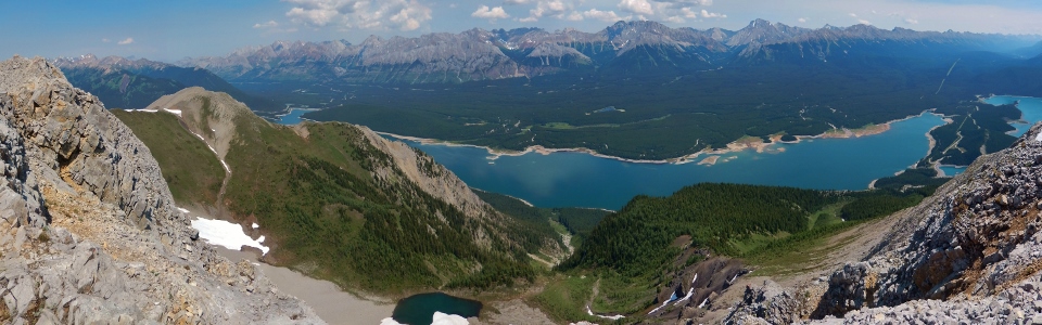
The panorama to the east is no less impressive featuring the Indefatigable tarn, Lower Kananaskis Lake, the Kananaskis Range, the Opal Range and the Elk Range. Click to see larger.
.jpg)
Colorful sandbars in the Lower Kananaskis Lake.
.jpg)
The tarn below looked like a nice place for a swim on a sweltering day like this!
.jpg)
The north end of the Opal Range. From left to right: Opal Ridge (low), unnamed, Grizzly Peak (low), double-summited Mount Denny, Mount Potts, Mount Evan Thomas, Mount Packenham and King Creek Ridge (low).
.jpg)
The southern end of the Opal Range: diminutive Gap Mountain in front of Elpoca Mountain.
.jpg)
Massive Mount Rae to the east.
.jpg)
Mount Rae’s brooding neighbor: Storm Mountain.
.jpg)
Can’t get enough of this view!
.jpg)
The standard summit hero shot.
.jpg)
With the hot sun beating down upon us, we were starting to melt so we took a quick family photo with the Lower (left) and Upper (right) Kananaskis Lakes before starting our descent towards shade!
.jpg)
Awesome views of the lush green Kananaskis Valley between the Kananaskis and Opal Ranges.
.jpg)
Running "low" on water as we descend steep sun-beaten alpine meadows – those lakes below are starting to look pretty damned inviting.
.jpg)
Alpine slip and slide.
.jpg)
Back down to beautiful Upper Kananaskis Lake.
.jpg)
Time for a swim to cool off – not sure which one of us needed it more!
.jpg)
.jpg)
.jpg)