In the care-free single days of my past, friends would, from time to time, set me up with a date. When I got married last year, I presumed that I was saying “goodbye” to all of that. Nevertheless, when Marko e-mailed to tell me that his friend Mike was looking for a (climbing) partner this past weekend, the situation felt oddly familiar. Like myself, Mike scrambles compulsively (he even has a very well-put-together website – GiantsGate.com) so it seemed to be a match made in heaven. Since my scrambling plans with at least 2 other groups of friends had already fallen through, I was eager to find someone to scramble with and asked matchmaker Marko to pass my contact info along to Mike. In short order, Mike and I were e-mailing back and forth discussing objectives.
After skipping out on my Saturday hiking plans in order to spend time with my lovely wife, I was given permission to do as long of a scramble as I wanted on Sunday. Seeking to take full advantage of this, I suggested a day trip up Mount Sarrail to Mike. The guidebook description of Sarrail does not even bother with a round trip time estimate, saying only that it is a “long day.” Given the recent dry weather, I hoped that Sarrail would be reasonably snow-free despite the fact that it’s a high peak near the Great Divide. However, even if it was snowy higher up, Kane’s “easy” rating had me convinced that it would still be feasible (more on exactly how “easy” it was later).
.jpg)
With the days growing shorter, Mike and I got off to an alpine start, meeting at the Upper Kananaskis Lake parking lot under a still-dark morning sky. In the faint light of dawn, Mount Sarrail (center) and its neighbor Mount Foch (left) were just barely visible across the lake.
.jpg)
The sky begins to brighten behind us to the east as we make our way along the south shore of Upper Kanananaskis Lake by head lamp.
.jpg)
The sun’s first rays cast their rosy alpenglow on Mounts Putnik (left) and Beatty (right).
.jpg)
After keeping a good pace along the south shore of Upper Kananaskis Lake, we reached the obvious (but unsigned) turn-off for Hidden Lake (left) in about 80 minutes.
.jpg)
From Upper Kananaskis Lake, a reasonably good trail brought us to the driftwood-littered shores of Hidden Lake. From here, the route contours the left (east) shore of Hidden Lake before ascending the headwall visible in the distance.
.jpg)
Easy travel along the dry shore of Hidden Lake. When water levels are higher earlier in the year, other parties have been forced to endure a relentless bushwhack through the forest on the left. Suffice to say that we were pleased to be spared this part of the Hidden Lake experience!
.jpg)
From Hidden Lake, the trail steeply ascends a small forested bump (visible below me to the left) before taking on the much larger headwall beyond. A good trail leads diagonally up rubble slopes to the climber’s left, aiming for weaknesses that are the key to gaining the headwall (photo courtesy Mike Mitchell).
.jpg)
Spectacular Fossil Falls tumbles down the steep headwall. As the trail makes its way along ledges ascending the left side of the headwall, it becomes mildly exposed. With light day packs and dry conditions, this was of little concern, however, Mike and I both wondered how scary this ascent might be in snowy conditions with heavier overnight/alpine packs.
.jpg)
Posing with one of several waterfalls that are passed while ascending the headwall (photo courtesy Mike Mitchell).
.jpg)
The “undulating rock ribs” that Kane recommends using to grant easy access to Mount Sarrail’s west ridge. Of course, rather than make life easy on ourselves, we continued along the Aster Lake trail beyond these features reaching a small seasonal pond despite Kane’s warning that the scree above this little tarn is “tediously loose.” After groveling up the slope above the tarn, I’m pleased to confirm that it is as unpleasant as described!
.jpg)
Once up the recommended rock ribs (or the tedious scree slope, should you choose your route poorly), the west ridge stretches out before you leading to the summit of Mount Sarrail beyond the north-facing glacier which briefly abuts the route. Although the lower and upper portions of Sarrail’s west ridge are easy as advertised, the middle section of the route, where the exposure level increases and the ridge grows slabbier, can more accurately be described as moderate scrambling (photo courtesy Mike Mitchell).
.jpg)
After spending the entire morning in forested areas and valley bottoms, the panorama towards Aster Lake grows more and more impressive with every meter gained along the ridge. From left to right: Mount Foch (outlier), Mount Petain (distant), Mount Marlborough, Mount Cordonnier, Warrior Mountain, Mount Northover, Mount Lyautey and Mount Warspite (distant). Click to see larger.
.jpg)
Golden alpine meadows lead to a bright blue tarn at the base of Mount Marlborough’s steep, glaciated north face.
.jpg)
Like a frog in water that’s slowly brought to a boil, the terrain on the ridge changes gradually from “easy” to “moderate,” luring scramblers further along the increasingly exposed ridge. Indeed, with fresh snow on down-sloping slab, some sections felt more in line with a “difficult” rating. Here Mike makes his way carefully upwards, hoping to avoid the frog’s fate.
.jpg)
Mike tackles the brief down climb just before the glacier abuts the ridge. Beyond this point, the snow-covered down-sloping slab forced us off the ridge and onto steep snow slopes just below the ridge crest on the climber’s left.
.jpg)
Attempting to kick steps through the snow; unfortunately, the snow was unconsolidated and gave very little support. With a steep glacier below to the left and the rock ridge to the right forcing a couple of awkward moves, we contemplated abandoning the ascent at this point. After some discussion, however, we both summoned the intestinal fortitude to make the traverse. So much for easy scrambling (photo courtesy Mike Mitchell)!
.jpg)
Beyond the snowy traverse, we arrived in a large wind scoop carved into the snow where the glacier abuts the ridge. The scoop provided shelter while we coaxed feeling back into our frozen fingers and added layers to cope with the increasingly frigid wind. Although Kane recommends avoiding the glacier and sticking to the rock on the climber’s right at this point, we were unable to distinguish between snow-covered rock and cornice to that side. Rather than risk a misstep to the right, we climbed out of the snow scoop and traversed a brief, solid and relatively level section of glacier (photo courtesy Mike Mitchell).
.jpg)
Mike follows my footsteps along the brief section of glacier. Note the exposure to the left (climber’s right) that we were attempting to avoid!
.jpg)
Having safely traversed the steep snow and brief glacier, all that separated us from the summit was a couple of hundred meters of steep, frozen scree! Fortunately, improving views (like this one of adjacent Mount Foch and a small tarn below) provided the inspiration necessary to suffer our way up the final summit slopes.
.jpg)
A closer look at the tarn between Mount Sarrail and Mount Foch, including the last remnants of, what likely used to be, a much larger glacier.
.jpg)
Success! 6 hours and 15 minutes after leaving the car, we reached the 3174 m high summit of Mount Sarrail. Impressively, Sarrail is my highest summit of 2014 (to date) and we reached it in October (photo courtesy Mike Mitchell)!
.jpg)
From the summit, the spectacular view to the north is dominated by the Kananaskis Lakes, the Haig Icefield (left), the Kananaskis Range (center) and the Opal Range (right).
.jpg)
An island of autumn color in Upper Kananaskis Lake nearly a kilometer and a half below.
.jpg)
Familiar Kananaskis Range peaks dot the horizon beyond Mount Warspite (left foreground) and Mount Invincible (center foreground). From left to right: the Tower (shaded), Mount Chester, snowy Mount Galatea, Mount James Walker, the north summit of Kent Ridge, sunny Mount Sparrowhawk, sunny Mount Bogart, pointy Wind Mountain, reddish Mount Inflexible and Mount Lawson.
.jpg)
The British Military Group, somewhat obscured by cloud, above the Haig Icefield.
.jpg)
Mike takes in the view.
.jpg)
Trying to see Elk Pass and the Misty Range beyond the summit cornice to the east.
.jpg)
Mount Rae dominates the horizon to the east.
.jpg)
Storm Mountain (left) and Mist Mountain (right) tower above the more diminutive Mount Tyrwhitt (foreground).
.jpg)
A snowy Mount Foch immediately to the south.
.jpg)
Despite a fair bit of cloud, Mount Joffre (the highest peak in Kananaskis) made a brief appearance beyond Mount Marlborough.
.jpg)
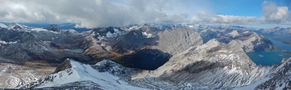
A break in the clouds grants a stunning view of the western panorama beyond Aster Lake and extending down to the Kananaskis Lakes. Click to see larger.
.jpg)
Warrior Mountain, Aster Lake and Mount Northover beyond Sarrail’s exposed ascent ridge.
.jpg)
A sun-splashed Mount Cordonnier.
.jpg)
Warrior Mountain and its small remnant pocket glacier.
.jpg)
A closer look at Aster Lake.
.jpg)
Cloud continues to obscure the massive peaks of the Royal Group beyond the impressively exposed southeast ridge of Mount Northover (left middle ground).
.jpg)
After a brief and chilly stay on top, it was time to begin our long journey back down (photo courtesy Mike Mitchell).
.jpg)
Slippery slabs resulted in some classic five-point descent technique (and a rip in the seat of my hiking pants).
.jpg)
Negotiating the crux above the steep glacier on descent. Once we were back across this section, we both breathed a little easier (photo courtesy Mike Mitchell)!
.jpg)
Now this is “easy” scrambling! With all of the exposed, snowy terrain now behind us, we were free to enjoy the wonderful views (like this one of Mount Lyautey’s southern outlier) as we made our way back down towards the Aster Lake trail (photo courtesy Mike Mitchell).
.jpg)
Mike pauses to enjoy the view of Upper Kananaskis Lake and what’s left of Hidden Lake from the top of the headwall. From here, the trail down to Hidden Lake can be seen atop the cliffs to the right.
.jpg)
Mount Invincible (left) and Mount Indefatigable (right) beyond Hidden “Lake.”
.jpg)
Asters around Hidden Lake fight to stave off the encroaching winter.
.jpg)
Although we followed a good trail from Upper Kananaskis Lake to Hidden Lake earlier in the day, we somehow managed to miss it on descent (despite the fact that we both had GPS units). I guess no visit to Hidden Lake is complete without some thrashing about through the thick brush!
.jpg)
Back down to the scenic shores of Upper Kananaskis Lake at the same elevation as our cars; only problem: they are, unfortunately, parked all the way across the lake…sigh.
.jpg)
Sarrail Creek was the highlight of an otherwise dull plod back around Upper Kananaskis Lake. The best part about this creek was knowing that, from here, it was only another 10 - 15 minutes back to the cars!
.jpg)
With the bridge at Sarrail Creek destroyed in last year’s floods, we improvised using wet logs, hoping not to end our already lengthy day with an unintended dip in the creek.
.jpg)
About 12 hours after starting out, we finally made it back to the trailhead in the fading evening light (more sore and tired than when we’d left). Damn that peak looks far away from here! Kane may not be right when he calls Mount Sarrail an “easy” scramble but he sure as hell is when he says it’s a LONG DAY!
.jpg)
.jpg)