Following a couple of peak-less but enjoyable winter weekends, I was looking forward to my next summit bid. I spent the work week watching gleefully as the avalanche danger rating dropped and the Sunday weather forecast improved! After numerous winter and shoulder season ascents in the Front Ranges, I was eager to take advantage of the forecast conditions to sneak in a winter ascent in the more spectacular (but much snowier) Main Ranges. With its relatively low objective avalanche hazard and stunning Skoki surroundings, I decided to attempt Heather Ridge despite the associated long approach. In an effort to cut down on approach time (and more importantly, descent time), I decided to ski as far as I could on skinny cross-country skis (I don’t have ATs) before switching over to mountaineering boots/snowshoes.
As the weekend approached, I sent out a flurry of Facebook messages to see if any other peak baggers would be interested in joining me. Unfortunately, most local peak baggers already ascended Heather Ridge last year. I was, therefore, unable to find anyone other than Crux for company. Fortunately, Crux and I get along wonderfully and as we drove towards Lake Louise, I was looking forward to a sunny day with my canine companion!
.jpg)
As we drove westwards, I pulled over at Lac des Arcs to watch the colorful sunrise beyond Heart Mountain. I would have preferred to get off to an earlier start to avoid the possibility of isothermal snow and increased avy hazard in the afternoon, however, I wanted to time our descent so that we would be skiing down well after the last chair at the Lake Louise ski hill. After all, the final 3.9 km of our descent would be on the Lake Louise ski-out and I hoped to avoid potential Crux crashes with speedy downhill skiers!
.jpg)
Enjoying the alpenglow on Grotto Mountain before resuming our journey west.
.jpg)
Once we arrived at the Fish Creek (Skoki Lodge) trailhead, Crux and I set off up the freshly groomed ski out towards the Temple Lodge. As you can see here, sections of the ski-out are steep; fortunately I had a dog on a leash to pull me up…or was it the other way around? ;-)
.jpg)
The ever-improving view of Mounts Temple, Hungabee and Aberdeen at our backs provided ample excuses to stop, turn around, enjoy the scenery (and catch our breath when the grade steepened)!
.jpg)
Beyond the ski resort, we continued upwards on a narrow ski track. Thanks to the shade of Redoubt Mountain’s west walls, the air in the valley was cool and Crux and I had soon grown white beards to match our snowy surroundings.
.jpg)
Redoubt Mountain’s west face rears up overheard shading our entire approach valley.
.jpg)
Skiing towards the light: Mount Richardson (left), Pika Peak (center) and Ptarmigan Peak (right) escape Redoubt’s shadow as we make our way towards Boulder Pass (far right).
.jpg)
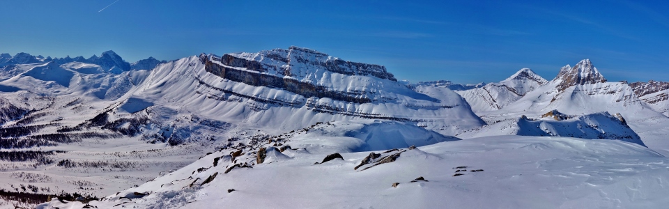
After a steep final ski up, we were greeted by spectacular views of Mounts Douglas (left) and St. Bride (right) beyond Boulder Pass’ namesake rubble.
.jpg)
From Boulder Pass, a wondrous winter panorama of Skoki peaks unfolds beyond the white frozen flats of Ptarmigan Lake. From left to right: Fossil Mountain, Mount Douglas, Mount St. Bride, Lychnis Mountain, Brachiopod Mountain and the day’s target Heather Ridge. Click to see larger.
.jpg)
Douglas and St. Bride.
.jpg)
Setting off across the frozen lake towards the snowy meadows between Heather Ridge and Redoubt Mountain. While Heather Ridge looks close from here, the summit is, unfortunately, at the extreme far (south) end of the ridge. To access it, Crux and I crossed the meadows and ascended the rubble-strewn slopes just visible on the far right.
.jpg)
As my skinny skis began to sink deeper and deeper into the snow below Redoubt’s north ramparts, it became obvious that it would be in my best interest to switch to snowshoes!
.jpg)
Post-holing puppy: they don’t make snowshoes in poor Mr. Crux’s size…if you ever need to tire out your dog, I can promise that a 24 km walk in the backcountry powder will do the trick!
.jpg)
A frozen Redoubt Lake sits at the base of Redoubt Mountain’s sheer east face. Although the Heather Ridge approach (which essentially involves walking all the way around Redoubt Mountain) is long, you do get to enjoy Redoubt Mountain from every angle!
.jpg)
Taking advantage of supportive wind-affected snow while negotiating our way upwards through the maze of boulders.
.jpg)
Crux reaches the “rock garden” on Heather Ridge’s upper slopes.
.jpg)
The pinnacles and boulders of the “rock garden” provide a dramatic foreground as Mount Richardson (left), Pika Peak (center) and Ptarmigan Peak (right) jut skywards in the background.
.jpg)
“Rock garden” selfie. From the rock garden, the false summit is easily reached in minutes. Discouragingly, you have to lose elevation to get from the false summit to the true summit (which is, quite fortunately, closer than it initially appears).
.jpg)
At last! Mounts Douglas and St. Bride welcome us to Heather Ridge’s snowy summit.
.jpg)
Crux enjoys a well-earned summit snooze in the sun. Good boy!
.jpg)
While Crux rested his eyes, I feasted mine upon the massive peaks beyond Heather’s long corniced ridge top! From left to right: Redoubt Mountain, Mount Daly (distant), Mount Balfour (distant), Mount Richardson, Pika Peak, Ptarmigan Peak, the Wall of Jericho, Mount Willingdon (distant), Mount Harris (distant), Cyclone Mountain, Fossil Mountain, Oyster Peak, Brachiopod Mountain, Mount Douglas and Mount St. Bride. Click to see larger.
.jpg)
Diminutive Brachiopod (left) and Tilted (right) Mountains give way to much larger Mount Douglas, Mount St. Bride and Lychnis Mountain to the east.
.jpg)
Looking northwest along the corniced ridge.
.jpg)
Redoubt Mountain and I.
.jpg)
An equally impressive panorama stretches out beyond remote alpine meadows to the south. From left to right: Mount Avens, Pulsatilla Mountain, Protection Mountain (TV Peak), Armor Peak, Bulwark Peak, Storm Mountain, Mount Ball, Stanley Peak, Boom Mountain, Mount Bell, Panorama Ridge, Bident Mountain, Quadra Mountain, the Valley of the Ten Peaks, Mount Temple, Mount Goodsir, Mount Hungabee and Redoubt Mountain. Click to see larger.
.jpg)
Self-timer summit shot with the Pulsatilla/Protection Massif.
.jpg)
A view worth post-holing for!
.jpg)
Storm Mountain (center left), Mount Ball (center) and Stanley Peak (center right) highlight the view beyond Bulwark Peak towards Kootenay National Park.
.jpg)
Massive peaks of the continental divide highlight the panorama to the west beyond Unity Peak, Lipalian Mountain, Redoubt Mountain, Mount Richardson, Pika Peak, Ptarmigan Peak and the Wall of Jericho. Click to see larger.
.jpg)
A closer look at the Valley of the Ten Peaks (from left to right: Mount Quadra, Mount Fay, Mount Babel, Mount Little, Mount Bowlen, Mount Tonsa, Mount Perren, Mount Allen, Mount Tuzo and Deltaform Mountain) and Mount Temple across the Bow Valley.
.jpg)
I just can’t seem to get enough of Redoubt Mountain (which is good because I still have to ski all the way around it to get back down)!
.jpg)
Mounts Niles (left), Daly (center) and Balfour (right) are just visible beyond Boulder Pass (bottom right).
.jpg)
Crux enjoys the last of the summit views before starting the long trek back down. Despite the spectacular scenery, we didn’t linger long on the summit, fearing isothermal snow and increasing avy hazard in the surprisingly warm afternoon sun!
.jpg)
Avoiding the corniced ridge crest on our way back up and over the false summit towards a distant Boulder Pass (center). Once back there, it’s only a “short” 8.6 km back to the car!
.jpg)
After a long trudge through softening waist-deep snow, Crux and I were greeted by the welcome sight of the Lake Louise ski hill and civilization from Boulder Pass. Better still, from here on down, there’s a packed trail the entire way!
.jpg)
Recharging his batteries at the pass (must be solar). Actually, we had to kill about 45 minutes at the pass to ensure that we didn’t reach the ski-out before the ski area was vacated for the day. Fortunately, there are worse places for an afternoon nap!
.jpg)
Killing time by watching 3 tiny skiers (bottom left) ascending open slopes beneath ominous-looking cornices on Ptarmigan Peak’s sun-soaked south face. Mouse over for a better view.
.jpg)
Once the lifts closed in the valley below, Crux and I enjoyed one final view of Brianne’s favorite boulder from the pass before swapping the snowshoes for cross-country skis. Resembling bats out of hell, Crux and I made quick work of the nearly 700 vertical meter, 8.6 km long, descent. This proved easier for me since I was on skis (run Crux run)!
.jpg)
.jpg)
.jpg)
.jpg)