Razor's Edge Peak
Elevation: 1725 m
Elevation Gain: 415 m
Razor’s Edge Peak is one of many unofficial names given to an obvious peak east of Heart Mountain on the TransCanada Highway. When driving east towards Calgary, the highway literally cuts through the foot of Razor’s Edge Peak as it rounds a sharp bend and makes its way out of the mountains. The name “Razor’s Edge” is taken from a popular mountain bike trail on the peak’s east-facing slopes. “The sharp edge of a razor” is said to be “difficult to traverse” (Katha Upanishad) and so too is this advanced trail if you’re cycling! Other unofficial names for this peak include: McConnell Point, Biffy Peak, GR320583, The Bump, Bear’s Bump, Bear’s Bum and Engagement Peak.
My Ascents:
November 5 2016
Trailhead: Razor's Edge Parking (Roadside)
GPS Track: Razor's Edge Peak (incomplete due to battery issues)
Having reached a tally of 199 different summits in my scrambling “career”, I decided that I should “go big or go home” for my 200th peak. Seeking big views on a big peak, Phil Richards and I attempted to scramble up Crowfoot Mountain only to be turned back by waist-deep snow on 45 degree slopes. Since my attempt to “go big” literally resulted in my “going home” without my coveted bicentennial summit, I decided to set my sights a little lower; 1325 m lower to be exact.
Ever since Rafal Kazmierczak told me about the little peak that he dubbed “Razor’s Edge”, I’ve been keeping it in my back pocket for a short shoulder season day out. When summer-like November weather lined up with an unexpected day off for Brianne, I, therefore, suggested that we attempt a family outing up Razor’s Edge Peak. Both the peak and the drive to get to it are relatively short (which is a good thing when you’re hiking with a baby). As an added bonus, tackling Razor’s Edge Peak with my wife and daughter (and Crux) would allow me to enjoy my milestone 200th summit with the best company imaginable (no offense Phil)!
After readying Mera and packing our gear, we started west along Highway 1 towards the “Lac des Arcs/Heart Creek” turnoff. From the turnoff, we merged back onto Highway 1 East and continued 3.5 km to the unmarked Razor’s Edge trailhead, parking on the broad grassy shoulder shown above. Although others have ascended Razor’s Edge more directly from the popular Quaite Valley trailhead further west, this route looked to involve some thicker bush and steep slabs which I didn’t want to attempt with a baby on my back. We, therefore, opted to ascend via the slightly longer “Razor’s Edge” bike trail thinking that the cycling path would be easier. Our route ended up working just fine but I must admit that the “Razor’s Edge” bike trail is much more difficult than I thought it would be! I have no idea how mountain bikers make it down some of the terrain on this route (and some don’t based on the pool of blood Crux found and reports of a rescue by Kananaskis Public Safety on the same day). Suffice to say that the trail isn’t terribly difficult on 2 feet but I wouldn’t want to attempt it on 2 wheels! Oh yeah – and you’ll have to bushwhack the final bit to the summit regardless of which way you go!
.jpg)
Brianne and Crux work their way up an obvious trail that ascends the open rock rib which is bisected by the highway. The trail quickly gains elevation and provides pleasant views if you're willing to tolerate the noisy road below.
.jpg)
The remains of a wind twisted pine stand guard over the Bow Valley. This stretch of highway is notoriously windy and, as one might expect, so is this section of the hike!
.jpg)
A large pine tree provides evidence of the brutal winds which are a common feature here - any guesses which direction the prevailing winds come from? I soon learned that baby carrier backpacks are really just big sails and spent a good amount of time struggling to stay upright amidst the gusts!
.jpg)
After ascending open, wind-scoured terrain for a km or 2, the path makes its way into the forest. While I'd been anticipating a wide, fire road-style bike path, we found nothing of the sort. The Razor's Edge trail is, in fact, a narrow single wide path infringed upon by a good number of branches. Indeed, one such branch accidentally caught poor Mera in the head as I ducked around it (Bad Dad)! Fortunately, mommy was able to cheer her up and daddy was much more careful from that point forward! :-(
.jpg)
2.3 km from the car, we reached the McConnell Ridge crest. Straight ahead, the ridge continues on towards Yates Mountain while Razor's Edge Peak rises up behind. It was at this point that we left the trail behind, very carefully bushwhacking up the lightly forested but steep east ridge of Razor's Edge Peak. Having a large baby carrier on my back added a degree of difficulty to the endeavor but we were able to get Mera up unscathed by carefully following game trails here and there.
.jpg)
Brianne and Crux enjoy some light bushwhacking on the east ridge.
.jpg)
Before long, we reached the false summit and eyed the slightly higher true summit ahead. From here the going was much more open and the ascent angle finally relented.
.jpg)
Mera tackles a final hands-on step to reach the summit of Razor's Edge Peak!
.jpg)
Heart Mountain (foreground left), Skogan Peak (left), Mount McGillivray (center) and Pigeon Mountain (behind my head) provide the eye candy while Mera and Crux provide the arm candy on my 200th summit!
.jpg)
Mommy helps Mera explore her summit surroundings.
.jpg)
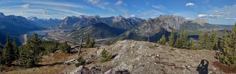
Razor's Edge might be a small peak but it certainly offers a big Bow Valley panorama. Click to see larger.
.jpg)
An outhouse with a view? The famous "biffy" from which one of the peak's many names originates.
.jpg)
Looking beyond Lafarge's Exshaw Plant and Lac des Arcs towards some notable Canmore summits including (from left to right): Pigeon Mountain, Wind Ridge, the Three Sisters (Faith Peak, Hope Peak and Charity Peak), Goatview Peak, Ship's Prow, Mount Lawrence Grassi, Miner's Peak and Ha Ling.
.jpg)
Grotto Mountain.
.jpg)
The karate kid? While I was busy snapping summit photos, my daughter amused herself with some kung fu in the wind. What a goof.
For more Goat/Karate Kid-related hilarity, click the link. Go on - do it!
.jpg)
The many treed summits of Exshaw Mountain and taller Mounts Fable (left) and Townsend (right) to the northwest.
.jpg)
The Bow River winds its way along the foot of the Old Goat Mountain massif (including Door Jamb Mountain on the left) while Yamnuska towers above the prairies on the right.
.jpg)
Hundreds of kilometers of prairie flatland stretch eastwards from the peak's base.
.jpg)
Crux and the view towards the Kananaskis Valley (including from left to right: Mount Baldy's north, south and west summits and the twin summits of Midnight Peak). Crux has a ways to go to get to 200 summits but Razor's Edge Peak did mark his 70th different Rocky Mountain apex! What a "good boy"!
.jpg)
My beautiful girls - the best summit company a guy could ask for!
.jpg)
Even though Brianne doesn't think that 200 summits is a milestone, I do. I'm very lucky to have visited so many beautiful places and I'll be forever grateful that my family joined me for this one and so many others over the years!
.jpg)
After enjoying the view (click to see larger) and letting Mera frolic about, it was time to bid adieu to the summit and begin our windy descent. On to the next hundred summits! Maybe once I hit 300 my wife will finally think that I've accomplished something! :-P
.jpg)
.jpg)