I don’t know where the summer of 2023 went. 😔 The snow melted; the grass turned green; wildfire smoke came and went (and came again 🔥). With the third weekend of August approaching, I had a mini-panic attack. In a week and a half, our kids would be back in school. Had we made the most of Alberta’s short summer season? Had we enjoyed it to its fullest? Most importantly, had I dragged my kids (and wife) up enough peaks this year?! 😏🙃 With a blessing in the form of fine Sunday weather, I decided that the time to put these doubts to rest was NOW! Highly motivated, I woke before dawn and had all of our hiking gear packed and ready to go when, one-by-one, my girls rolled out of bed.
Despite having everything ready, it still took some time to get my wife Brianne caffeinated ☕ and the rest of the girls fed, dressed and ready to leave. Still, by 9 am we were on the road! Our destination for the day: magnificent Highwood Pass, which is the highest paved pass in Canada. Thanks to its near-tree-line elevation, a number of wonderful hikes pass through Highwood’s alpine environs and we decided to finally take our kids on an old favorite of Brianne’s: Pocaterra Ridge.
.jpg)
.jpg)
LEFT: A month from now, this pass will be impossible to access due to larch madness (a phenomenon which results in a mass migration of Instagrammers from Calgary to any nearby mountain-scape that has yellow trees 🙄). In mid-August, however, things are much more reasonable, and we were able to secure a coveted parking spot despite arriving a short time after 11 am. As you can see, Lillian was jacked to be back in the area (having only hiked here once before (some 10 months earlier)!
RIGHT: From the parking lot, we followed the interpretive trail to the northwest for a short distance before leaving it for the smaller spur trail pictured here (the main path continues across the highway towards Ptarmigan Cirque). After a short foray through this meadow, the trail wanders into the woods ahead.
.jpg)
The woods near Highwood Pass are home to a number of springs and mossy slopes. Unfortunately, this area has been heavily damaged by overuse and mismanagement; Pocaterra Ridge is probably one of the most visited trails in K-Country, yet Alberta Parks does not treat or maintain it as such. Despite a growing number of trails through the woods, I witnessed careless hikers sinking ankle-deep and destroying soft mossy areas to shave a meter or two off their days. Until Parks decides to build a proper, “official” trail here, please mind where you step, stay on a trail and avoid traipsing unnecessarily through the sensitive springs. As you can see here, even a 5-year-old can hurdle these so please minimize your impact accordingly!
.jpg)
After ascending spring-filled slopes, the trail(s) crested a shoulder and side-hilled down the other side. Again, this area showed ample signs of overuse. Where once a single trail passed, there was now a wide swatch of destruction wrought by the many boots that wander up and down here.
.jpg)
After about 1-km in the viewless woods, the alpine scenery exploded quite suddenly (and panoramically) 🤩 as we contoured around Highwood Ridge (out of frame above on the left) and started towards our objective, Pocaterra Ridge, on the right. Click to see larger.
.jpg)
.jpg)
LEFT: Sisters Mera and Penny enjoy the views in the still-cool morning shade. Starting at so high an elevation has perks (amazing alpine scenery almost right away) but it also comes at a cost; even though it was noon by now, it was still freezing! 🥶 Despite the cool temperatures, these girls were amazing hikers to start the day – in fact, Brianne and I could barely keep up with them as they raced along the trail, hunted for mushrooms 🍄 and told each other tall tales ("Right, Mera?").
RIGHT: Eventually, the sun succeeded in making its way over Highwood Ridge, bringing the valley’s vibrant, violet fireweed into stunning focus. With some solar energy on our side, the temperatures quickly increased and our jackets were doffed in short order. 🌞
.jpg)
Mera and Penny make their way through a scenic sea of fireweed.
.jpg)
Ahead, rocky Mount Pocaterra rises above its grassier namesake Ridge. From here, the trail contoured around the valley on the left, before aiming for the Ridge’s gentlest (left-hand) slopes.
.jpg)
Looking back as Mera and Penny amble through a brief boulder field. Despite being easy to traverse, this boulder field slowed our girls to a near-crawl 😐 as there were sparkly micro-crystals in the rocks…
.jpg)
.jpg)
LEFT: Eventually, we managed to get the girls out of the shiny boulders. As you can see from this photo, however, Penny proceeded to pout for a while afterwards.
RIGHT: As anyone with kids knows, an effective ways to deal with pouting is to feed them, so we made haste along the trail to a nearby tarn, where we enjoyed an overdue lunch break.
.jpg)
Sandwiches and scenery in the sun. 🥪
.jpg)
.jpg)
LEFT: After lunch, we started anew, continuing up towards the base of the ascent ridge. Unfortunately, Penny’s blood sugar must still have been low, as she continued to be a bit of a turd 💩 on this section and argued needlessly about anything she could think of. Fortunately, Brianne had the patience of a saint and was eventually able to redirect her into a more positive mindset!
RIGHT: Maybe it was low blood sugar or maybe Penny just didn’t appreciate having to gain elevation on, sometimes, steep slopes? 🤔
.jpg)
Nearing the alpine meadows at the base of Pocaterra Ridge, we were treated to wonderful views of Grizzly Ridge (left), Grizzly Col (center) and Mount Tyrwhitt (right) to the south. We’d also debated hiking up Grizzly Ridge as a family on this day, but decided that Pocaterra looked much more kid (and wife 😂)-friendly!
.jpg)
Having hiked about 3.5-km from the parking lot, we reached the base of our objective (where the fun really starts)! 😎 So far, we’d gained about 130 vertical meters. Over the next 1-km, we’d need to gain another 350 vertical meters!
.jpg)
.jpg)
LEFT: Mera, Penny and Brianne start up a ridiculously steep grass slope at the base of Pocaterra Ridge. While Penny had been whiny on mellower terrain below, she (for some reason) charged up this borderline-vertical hill with unexpected enthusiasm! 🤯❤️
RIGHT: 3 of my 4 girls power up Pocaterra Ridge, with much larger Mount Pocaterra looming above. The fourth girl was, of course, on my back napping. 😴 Ah, to be 11-months-old again…
.jpg)
Craning our necks skyward, we noted a group of scramblers descending Mount Pocaterra’s summit ridge.
.jpg)
.jpg)
LEFT: Brianne and Penny enjoy a temporary respite from the steep ascent grade about halfway up the Ridge, while Mount Tyrwhitt stands tall above Pocaterra Cirque to the south. As Brianne fell back slightly, Mera suddenly decided that this ascent would be a kids vs. adults race and took off towards the summit like a SHOT. 🏃♀️🚀
RIGHT: Looking back towards Brianne and Penny, I noted another group of scramblers fooling around on Mount Tyrwhitt’s dramatic rock arch. By the time that I stopped for this photo, Mera had already raced halfway up Pocaterra Ridge. Despite a valiant huff-and-puff on the part of the adults, there would be no catching her!
.jpg)
The winners of the summit race – Team Monkeys! 🙉 It was actually amazing to see what these two could do when they were randomly motivated. 😂 Mera, in particular, was unstoppable on Pocaterra Ridge’s steep, grass slope, which reduced a number of other (adult) hikers to crawling on all fours!
.jpg)
This proud papa 😊 needed a summit selfie with his speedy mountain girls (when he eventually caught up with them)!
.jpg)
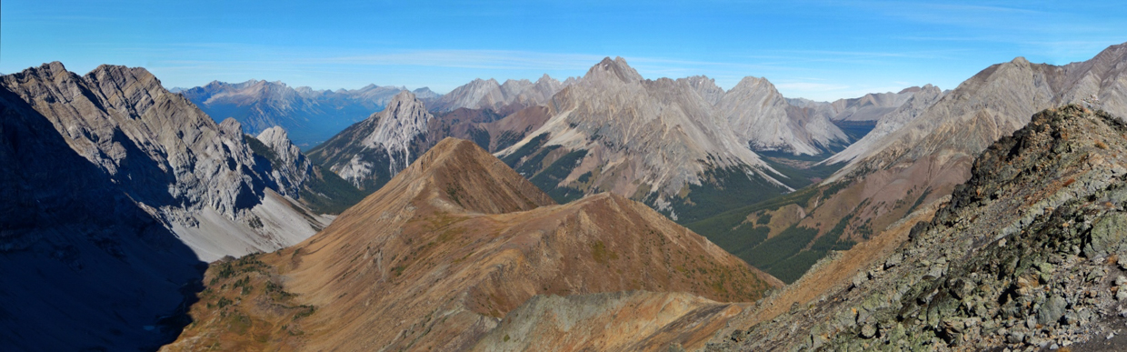
I’ve been up Pocaterra Ridge at least four times now and this summit panorama is one of the main reasons that I keep coming back! Even on a somewhat smoky day, PR is among the best bang-for-your-buck hikes in K-Country. Click to see larger.
.jpg)
Immediately west, larger Mount Pocaterra towers above. While the peak is pretty, it also obstructs (what must be) a wonderful view towards the Kananaskis Lakes. Guess I’ll just need to scramble up it if I want to see them…
.jpg)
To the northwest, Pocaterra Ridge undulates up and down for several kilometers. Beyond the ridge, Gap Mountain, Mount Elpoca and Tombstone Mountain stand tall. These peaks probably provide fine views for those who traverse the whole ridge but I’ve never bothered. The up-and-down route has always been enough for me on Pocaterra Ridge. If I’m going to turn a small day into a big one, I may as well just do a big peak to start! 😝
.jpg)
To the north, Mount Rae looks reasonably tame but memories of my 2009 ascent of this peak beg to differ with this assessment. Maybe it’s eroded somewhat since then? 😂
.jpg)
The only thing that could make this summit view any prettier: my beautiful little hikers, happy to be On Top again! 😍 This is how you get the most out of summer! 🥰
.jpg)
The smoky but spectacular summit panorama north and east over Highwood Pass. Click to see larger.
.jpg)
Looking across Highwood Pass towards Ptarmigan Cirque (a lovely little hike), Mount Arethusa (a scary-as-hell scramble) and Little Arethusa (a beautiful slog).
.jpg)
To the east, Storm Mountain’s vertical rock strata hint at how exposed its southeast ridge route feels.
.jpg)
Pocaterra Ridge’s northward panorama is filled by nearby Highwood Ridge, Grizzly Ridge, Mount Tyrwhitt and Mount Pocaterra. Click to see larger.
.jpg)
A closer look at Highwood Ridge: another wonderful hike in the area. Beyond Highwood, Storm and Mist Mountain are also apparent.
.jpg)
An obvious geological fault separates Grizzly Ridge (left) from Mount Tyrwhitt (right).
.jpg)
.jpg)
LEFT: Our littlest hiker Lillian brought a couple of blocks along for the hike to celebrate her most recent milestone. While she may only be 11-months-old, Pocaterra Ridge was her 13th different summit! Go Lilly! 🥳
RIGHT: Working on her “hiking legs”… Before you know it, Lillian will be racing up these peaks with her big sisters!
.jpg)
Our (surprisingly) color-coordinated family On Top of Pocaterra Ridge. 😊 After a summit snack for the kids, summit boob for Lillian, and a small (quickly interrupted) summit nap for Brianne, we decided that we’d best start down. While the kids raced up Pocaterra Ridge, there was no guarantee they’d hold that pace (or any reasonable one) on the way down…
.jpg)
Most of the initial descent is quite steep but proved manageable for Mera on her own and Penny (with a hand from Mom). Where once there was grippy grass on this slope, only slick, dry dirt remains now. Again, overuse and Parks mismanagement are sad themes on Pocaterra Ridge. A switchback trail could probably save the alpine flora here, but the current Alberta Government doesn’t seem keen on reinvesting the K-Country user fee that they instituted…
.jpg)
.jpg)
LEFT and RIGHT: With the steepest slopes behind, our girls made quick work of the egress hike from the ridge’s base. Again, motivation proved to be the key to keeping the littles moving. For Mera, we challenged her to make it back to the car in 1-hour (and then had to constantly yell for her to “wait up!” as she, again, raced ahead). 😂 For Penny, Brianne invented a “Baby Bear, Baby Bear, what do you see?”-based game 🐻 that eventually became repetitive but kept Penny moving and entertained! Feed them and interact with them? Are these the keys to successful parenting that we’ve been missing all along? 🤔🤯😂
.jpg)
Speedy Mera, speedy Mera, what do you see? I see a tarn about to splash beneath me… About a minute after this photo was taken, Mera’s shoes ended up, predictably, soaked. At least it happened on the way down not up…
.jpg)
Pretty tarn, pretty tarn, what do you see? I see a panoramic photo that gets larger if you click on me.
.jpg)
Fireweed, fireweed, what do you see? I see two amazing little girls hiking through me! 🥰
.jpg)
.jpg)
LEFT: Parting, fireweed-filled views towards Gap Mountain and Mount Elpoca as we prepare to leave the open alpine behind for the hike’s final, forested kilometer.
RIGHT: Side-hilling up on a bit of butchered trail: not an ideal way to end a beautiful hike but our still-motivated little girls didn’t seem to mind! By this time, Brianne and I were complaining more than they were! We’d had enough elevation gain already…
.jpg)
Penny enjoys one of the few “trail improvements” put in place by Alberta Parks. These unstable log “cookies” were fun for kids but I’m not sure that they prevented trail erosion near these springs in any meaningful way.
.jpg)
.jpg)
LEFT: With the spring and side-hill-filled forest behind us, Mera and Penny adorably finished the hike back to Highwood Pass hand-in-hand in a beautiful alpine meadow. More impressive still, thanks to a stopwatch and “Baby Bear, Baby Bear, what do you see?” we actually made it down in an hour! What amazing little hikers we have.
RIGHT: Since all of my girls were SO cooperative on the hike and we made it down at a reasonable hour, I decided to stop at the High River Brewing Company for a “treat” on the way home. While Mera and Penny enjoyed their well-deserved cream sodas 🥤 and Lillian enjoyed her bottle of fresh milk, 🍼 no one was more excited about her "special drink" 🍺 than Brianne.
Summer in Alberta may be short but, thanks to days like this, I’m confident that we’re making the most of it!
.jpg)
.jpg)
.jpg)
.jpg)
.jpg)