Elevation: 2820 m
Elevation Gain: 1180 m
Eagle Mountain was named for the golden eagle which passes through the Canadian Rockies twice per year as part of its annual migration. As these birds of prey travel between the western United States and Alaska/Yukon, they often follow the southeast to northwest trending ranges of the Canadian Rockies which generate updrafts that allow them to soar effortlessly. Despite the fact that Eagle Mountain’s name became official in 1958, the Sunshine Village Ski Resort has erroneously branded the peak as “Goat’s Eye Mountain.” The “Goat’s Eye” is a 25-m by 15-m window created by a rock arch on Eagle Mountain’s northeast ridge. This feature was first noted by George Simpson during his 1841 explorations of, what would eventually become, Banff National Park.
My Ascents:
July 26 2020
Trailhead: Sunshine Village Parking GPS Track: Eagle Mountain
Since an afternoon with our kids can be as tiring as bagging a peak, we decided to scramble up something nearby and short so that we’d be back in time to spell off the, already tired, babysitters before it got too late. We also wanted to make sure that we were home before Grandma and Grandpa drank the rest of our cold ones! Although Brianne was skeptical, I told her that we could be up and down Eagle Mountain in 5-hours and, so, we set off towards the Sunshine Village to enjoy a bluebird, kid-free day in the Canadian Rockies!
LEFT: As we pulled into the monstrous parking lot, we were annoyed to discover that Sunshine had closed the gate at its entrance. With their summer operations suspended due to COVID-19, they pointlessly decided to make backcountry users like us hike an extra 600-m (1.2-km return) across desolate pavement. As you can see, Brianne was not impressed!
RIGHT: At least our lengthy jaunt through the empty parking lot provided an opportunity to size up Eagle Mountain (right) and the “Goat’s Eye” on its northeast ridge (left).
A closer look at the “Goat’s Eye”.
Once we'd crossed the massive parking lot, Brianne set a blistering pace up the ski-out. Earlier, she mentioned that she was concerned about her scrambling conditioning. Now, I was shocked when she rocketed off leaving me in her dust!
LEFT: Without summer guests to ferry up and down from the Sunshine Meadows, the ghostly gondola was quiet overhead as we hiked up the hot ski-out.
RIGHT: The local wildlife kept a watchful eye on us as we made haste up the uninspiring road.
Another, rarer, wildlife sighting: the elusive Rocky Mountain $hitter in its native habitat!
After hiking 4-km up the winding ski-out road, we reached the Goat’s Eye Gondola Station and took advantage of ski hill infrastructure to rest and enjoy a snack with a view. I tried to convince Brianne to sit on the new toilets but she found the Adirondack chairs more to her liking…
After a pleasant respite, we started up Eagle Mountain using the winding Sunshine Coast ski run (tire tracks on the far right above). While it is possible to hike up more directly, we reasoned that the gentlest route would be the best one on a hot summer afternoon!
Mount Howard Douglas looms above “Sunshine Coast”. As we continued up, Brianne was relieved that this wasn’t the mountain we were aiming for. Of course, I didn’t tell her that our target was about equal in elevation…
After following “Sunshine Coast” for an unnecessarily long distance to the south, the ski run finally turned back north towards Eagle Mountain.
As "Sunshine Coast" swung back to the north, Brianne grew weary about all the extra distance that its sweeping path covered. Rather than continue past the summit (again), we therefore went straight up a black diamond ski run (the aptly titled “Fall Line”).
LEFT: The trade-off to doing so was obvious: less distance but one hell of a grind.
It was around this time that Brianne and I began to have a serious discussion (in between huffing and puffing). Without being overly moody, she informed me that this wasn’t really her idea of fun anymore. For years, I’ve counted myself as being incredibly blessed to have a wife who will join me for so many of the mountain adventures that drive me. Since we had kids, however, she no longer seems to care for the release of a good sweaty, slog. While this saddened me deeply, I can understand why. Slogging up mountains generally isn’t fun at the time and, sometimes, even after. Frankly, I don’t know why I love subjecting myself to this kind of "suffering" but I do. In an uncharacteristic attempt to be sensitive, I thanked her for her honesty and for following me up this miserable slope. We then continued up in silence as we contemplated, what might be, the end of an era for us; an era filled with big peaks and big adventures. Still, adventures don’t have to be big to be worth sharing with the one that you love.
RIGHT: While our ascent line was unpleasant, it effectively rocketed us skyward. Indeed, we covered 270 vertical meters in only 30 minutes! The payoff for our sweat investment was the spectacular view towards the Sunshine Meadows which unfolded behind us.
As we crested the steepest portion of the ski run, the top of the “Goat’s Eye Express” and the summit (250 vertical meters above) finally revealed themselves. Brianne agreed to accompany me as far as the top of the lift but told me she’d be happy to wait there while I continued to grovel up scree above.
A bittersweet selfie with my wife from the top of the ski hill. Normally, I hate splitting up. I believe that if you go out together, you should stay together. Having said that, I wanted to tag my precious summit and Brianne told me she’d feel guilty if I didn’t. Once we ensured that she had food to eat and the bear spray (so that I’d get eaten instead of her), we parted and promised to reunite in about an hour.
READY – SET – GO!!! Not wanting to leave my wife for an undue length of time, I made haste and, at times, literally tried to run up the final scree slog to the summit.
As I raced upwards, I aimed for these strange leaning rock pillars. Although they weren’t particularly large, they were visible the entire way up and made good targets to hone in on. Mercifully, the summit was along the ridge only a minute or two beyond them.
Beyond the rock pillars, the nearby summit and the airy east face of Eagle Mountain came into view.
A quick but scenic jaunt along the broken summit ridge ensued. Sections like this appeared to have fallen away dramatically. As a result, walking too close to the edge seemed foolhardy!
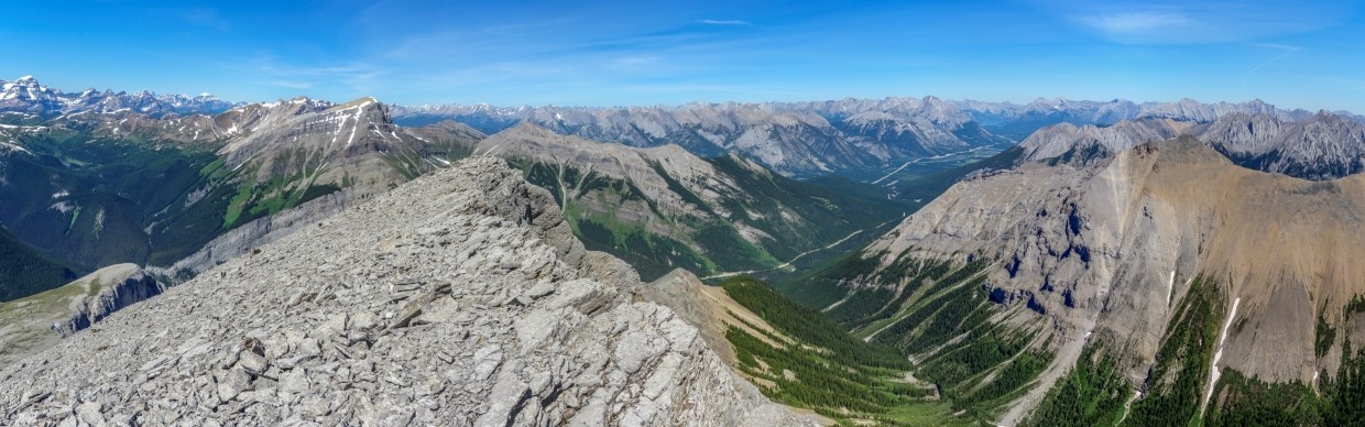
Only 20-minutes after parting ways, I reached Eagle Mountain’s summit and was treated to a mind-bending panorama towards Kananaskis Country (left), Mount Assiniboine Provincial Park (center) and the Sunshine Meadows (right). Click to see larger.
Despite its proximity to the civilization, the Sundance Range does not feature a single named peak between the Bow Valley and Beersheeba Peak – that’s a span of 24-km which encompasses 7 possible peaks!
To the southeast, Beersheeba Peak’s glaciated north face makes it stand out – maybe that’s why it got a name when so many other Sundance summits didn’t? Beyond Beersheeba, the Tower and Mount Galatea are the prominent peaks on the left while Mounts Allenby and Mercer just squeeze their way into frame on the right.
To the south, majestic Mount Assiniboine makes a dramatic appearance beyond Mount Howard Douglas (center left).
The “Matterhorn of the Rockies”: Mount Assiniboine.
The Sunshine Meadows add a splash of color to the many snow-covered peaks that dot the horizon to the southwest. Click to see larger.
Having not been atop a peak solo in some time, I reacquainted myself with my camera’s 10-second timer after a mad dash along the crumbling ridge. Photo courtesy the summit cairn.
Rock Isle Lake and the popular trail that leads to it are obvious from above. Beyond the mellow Sunshine Meadows, views include the distant Purcell Mountains and stretch from the Mitchell Range (left) to snowy Mount Shanks (right).
A dramatic quintet of Mitchell Range peaks towers over the fire-ravaged Simpson River Valley. From left to right: Mount Selkirk, unnamed, Caitlin Peak, incredibly point but unnamed and Split Peak. To the left of the quintet, Lachine Mountain is obvious while distant Mount Nelson is prominent along the horizon to their right. Thanks to remarkably clear skies, this view includes peaks as far as 125-km away!
Mount Shanks (center left) and the Monarch (right) dominate the view to the west. Beyond, the snow-capped Purcell giants of the Starbird Range are all visible if you know where to look!
The Monarch (left) and Hawk Ridge (right) rise up beyond tiny Twin Cairns (foreground). Behind the more proximate peaks, the twin summits of Mount White Tail (center) and Mount Verendyre (right) are rather in-your-face while the 85-km distant Bugaboo Spires are also visible.
WHAT-A-VIEW! Click to see larger.
Vermilion Range giants Mount Verendyre, unnamed, Floe Peak and Foster Peak rise up (from left-to-right) beyond the mellow Monarch Ramparts and unofficially named Talc Peak.
The Sphynx, Scarab Peak, Haiduk Peak and the Pharaoh Peaks reside beyond Healy Pass and more proximate Wawa Ridge to the west. Foster Peak (left) and Rockwall Peak (center) are among the Vermilion Range giants that are obvious beyond the Egypt Lakes group.
To the northwest, pointy Deltaform Peak and Mount Hungabee bracket more proximate Storm Mountain on the left while Mounts Lefroy and Temple are obvious on the right.
To the north, the verdant Healy Creek (left) and Brewster Creek (center right) valleys merge and continue their journey down towards the Bow Valley and Banff (right). Click to see larger.
That Sunshine access road in the foreground is one of the reasons that Eagle Mountain is such a short day. It’s always nice when you can drive 8-km and gain 300 vertical meters (even when you have to walk the entire length of the damned parking lot)!
A host of Sawback Range peaks to the north. Mount Cory is the obvious orange-tinged peak at center.
Looking northwest towards Banff and Lake Minnewanka.
To the east, the Devil’s Head, Mount Inglismaldie, Mount Girouard and Mount Peechee are all visible beyond Banff.
Banff landmark Mount Rundle looks much different from this angle! Trails in the scree attest to the popularity of its official summit (center left) even if it’s been established that the snowy high point on the right is higher.
Since we hadn’t planned on a kid-free outing, my scrambling pack had been left at home and I was “forced” to summit Eagle Mountain with our toddler’s hiking carrier. Despite the absurd appearance of carrying such a pack sans-child, it proved effective and I only had to deal with a few sarcastic comments from backcountry campers on the hike up the ski-out. As I searched the hiking carrier for my water bottle atop Eagle Mountain, however, I discovered that I had a “passenger” with me all along (cue the Jaws theme). Having carried “Baby Shark” all the way up the mountain, it only seemed fitting that I let him (or her?) out to enjoy the view. Clicking “Play” is not advised for the faint of heart (you’ve been warned)!
After a quick flurry of summit photos and some silliness, it was time to pack up and run down the mountain towards my wife some 250 vertical meters below.
“How’s my time Coach?!” After a knee-jarring run down Eagle Mountain’s upper rubble, I returned 45-minutes after departing and found my wife quite satisfied to be sitting on the sunny ski patrol deck with an ample supply of trail-mix and cell coverage that allowed her to watch Netflix (SERIOUSLY). I guess this is what “Netflix and Chill” looks like our household!
After Brianne asked me how the summit was and I asked her how the season finale of her show was, we turned our attention towards GTFD’ing. Having spied more appealing lines of descent from the summit, I advised that we should avoid steep scree by sticking 1 or 2 ski runs further to the north (skier’s right).
LEFT: This descent option avoided the worst of the scree but, as you can see, it was still STEEP! Upon reaching “Sunshine Coast” at the mid-mountain mark, we decided to continue straight down a black diamond ski run (“Afterburner”) since we’d already been on steep terrain for the entire upper mountain and didn’t care to walk all the way down the longer but easier ski run.
RIGHT: As we descended, the moon made a dramatic mid-afternoon appearance beyond Mount Howard Douglas.
LEFT: Back at the Goat’s Eye gondola station, we once again enjoyed a brief sit in comfy Adirondack chairs (why don’t all Rockies summits come so equipped?) before starting back down the dull ski-out access.
RIGHT: After I informed Brianne that there were a couple of cold craft beers waiting for us in the car, the rest of the descent turned into a trail run! While a jarring jog down the ski-out doesn’t sound pleasant, this was actually my favorite part of the day! Indeed, our little jaunt brought back fond memories from our pre-kid existence, when we would run side-by-side for hours on end. In addition to making my knees sore, this 4-km trail run served as a good reminder that any activity can be fun with the right company!
After descending the ski-out at a speed that would have done downhill skiers proud, we reached the baking hot (and EMPTY) parking lot and hiked a final, desolate 0.6-km to our car on the other side of the LOCKED gate (thanks again Sunshine Village!).
While Brianne had been skeptical when I told her that Eagle Mountain could be scrambled in 5-hours return, I felt vindicated when we found ourselves back at the car a mere 4.5-hours after setting out. Since our (more-tired-than-ever) babysitters weren’t expecting us back for another 30 minutes, we elected to enjoy a couple of cold ones while Healy Creek babbled on by. As we soaked up the post-scramble sun and suds, I wondered if Brianne was truly done with peak-bagging as we’d discussed. If this was going to be the end, however, at least we’d gone out on top with a bluebird day, cold craft beer and (most importantly) each other!
Postscript (and spoiler alert): you can’t keep a good Goat down! Only a week after swearing off scrambling forever, Brianne was right back in action and on top! Stay tuned...
.jpg)
.jpg)
.jpg)
.jpg)
.jpg)
.jpg)
.jpg)
.jpg)
.jpg)
.jpg)
.jpg)
.jpg)
.jpg)
.jpg)
.jpg)
.jpg)
.jpg)
.jpg)
.jpg)
.jpg)
.jpg)
.jpg)
.jpg)
.jpg)
.jpg)
.jpg)
.jpg)
.jpg)
.jpg)
.jpg)
.jpg)
.jpg)
.jpg)
.jpg)
.jpg)
.jpg)
.jpg)
.jpg)
.jpg)
.jpg)
.jpg)
.jpg)
.jpg)
.jpg)
.jpg)
.jpg)
.jpg)
.jpg)
.jpg)
.jpg)
.jpg)
.jpg)