With our short northern summer in full swing, I grew restless. The end of July was at hand and, with a new arrival due in September, there were more potential scrambling days behind than ahead in 2022. Sensing my angst (and probably sick of hearing me wax on about random mountains 😂), Brianne suggested that I escape to the hills for a “big day” (since I seem to be incapable of planning any other kind at this point 🤷).
After surveying a few potential partners, I was thrilled when guidebook author extraordinaire/cornice enthusiast Andrew Nugara indicated that he’d be interested in a suffer-fest of some significance. As we began planning, our proverbial peak-bagging eyes proved bigger than our summit stomachs. Indeed, some genuinely absurd ideas were seriously considered (particularly since I had to be back in Calgary by 10 pm so that my RN wife could go to work).
In the end, we settled on Kootenay’s Mount Shanks. Shanks had recently come to my attention during a family hike along the Simpson River (which runs along its base) and I knew that it could be scrambled thanks to Vern Dewit/Phil Richards’ 2020 reports. The peak isn’t much to look at, nor is it particularly high or prominent, but it is rarely ascended and features a long (9 km return), scrambly ridge which promised to be scenic thanks to its central Rockies location. For his part, Andrew was also familiar with Shanks having been thwarted during a winter attempt with the Crazy Pol Raf 10 years earlier. Despite having sworn never to attempt Shanks again during “this lifetime”, Andrew humored me, and we agreed to leave Calgary at 3 am. 😴🥱
.jpg)
After a slightly delayed departure (I realized that I’d forgotten my Fitbit minutes after leaving home and decided to go back for it), we arrived at the Simpson River trailhead just before 6 am. As we crossed the Vermilion River, whisps of cloud glowed pitch pink in the pre-dawn light. 🌄
.jpg)
From the wildfire-ravaged plains on the east bank of the Vermilion, we were treated to our first views of the day’s objective: Mount Shanks. In the image above, Shanks’ summit is obvious at center as is its long south ridge (right). The ridge is, however, so lengthy that the ascent slopes on its south end don’t fit within the frame of this picture!
.jpg)
.jpg)
LEFT: Anticipating a long day, we aimed to “make time” along the Simpson River trail (which we’d follow until we reached Shanks’ south ascent slopes 6.8 km from the trailhead). While it took me an hour to hike to these red chairs with my family, Andrew and I reached them in a quarter of that time. 🏃♂️
RIGHT: Rosy alpenglow creeps down nearby Mount Wardle’s sheer east face (prompting more than a couple photo stops that briefly slowed our pace).
.jpg)
During our approach, a speedy Andrew graciously swept the scenic Simpson River trail for tripping hazards. 🙃
.jpg)
Mount Shanks casts a long shadow west towards the spectacular Vermilion Range. As we sped along the trail, we watched the sun creep ever closer with some trepidation; the day’s forecast high was over 30 degrees C and we were fairly keen to cover as much ground as possible in the cooler morning shade. Unfortunately, scenery like this conspired to slow us down!
.jpg)
Let the roasting of scramblers begin! ☀️ As the rising sun finally illuminated our fireweed-filled surroundings, the temperature rapidly rose. 🌡️
.jpg)
Panoramic views of the serpentine Simpson River and its wild, fire-ravaged surroundings. Click to see larger.
.jpg)
.jpg)
LEFT: 6.8 km from the highway, we left the trail behind at a point just before it dropped down to the scenic Simpson River. My GPS indicates that it took us 1 hour and 40 minutes to cover this ground but it felt much faster as we chatted and gawked at our spectacular surroundings. 😍 Hours later when we returned to the trail, the situation would be reversed during a quiet and exhausted exit hike that felt endless!
RIGHT: Andrew was clearly more excited than he ought to have been to be off-trail on Shanks (again)! 😂
.jpg)
.jpg)
LEFT: Shanks’ south-facing ascent slopes loomed ominously above as we picked our way through terrain that, for now, was relatively open thanks to 2017’s Verdant wildfire.
RIGHT: While the singed slopes allowed for faster travel post-fire than they would have before, one had to be careful lest they find themselves shanked by Shanks! 🔪 Spear-like tree remnants were everywhere and they could easily impale any scrambler who slipped off of or tripped over one of the area’s many fallen logs.
.jpg)
Typical terrain on Shanks’ lower south slopes. The going was neither awful nor was it excessively easy. Obviously, your mileage may vary significantly depending on how you choose to amble up this. In general, we trended gently to the climber’s right, trying to follow the most open terrain.
.jpg)
.jpg)
LEFT: Andrew enjoys an unusually open slope as Split Peak makes a spectacular appearance to the south.
RIGHT: Hmmm. Must have made a wrong turn somewhere? Mercifully, this collection of pick-up-sticks deadfall was brief and, by angling up and to the climber’s right through it, we reached the open avalanche slope that Vern/Phil described.
.jpg)
.jpg)
LEFT: At the base of the avalanche slope, we stopped in a tiny patch of shade, refuelled and questioned the life choices that brought us to this point. It was now mercilessly HOT and, for lack of a better description, the slope ahead was STUPID steep.
RIGHT: Scenic suffering. The slope was steep enough that you essentially ascended it on the balls of your feet with your heels never quite touching the ground. The result: a mixture of throbbing pain and cursing. But hey, paintbrushes, amirite? 🌹😂
.jpg)
Given the heat and ascent angle, every patch of wildflowers on this slope merited a photo break. 😝
.jpg)
Out of the frying pan 🍳 and into the fire! 🔥 After grinding up the absurdly steep avalanche slope we found ourselves on a cooking HOT scree slope that proved no better. As you can see, it wasn’t not steep…
.jpg)
Somehow I managed a smile during my ascent of the blocky scree. This scree was that extra special variety that sucks equally on ascent and descent! Photo courtesy Andrew.
.jpg)
Mercifully, the scree and the ascent angle both abated as we reached the south ridge and treated ourselves to a gentler, grassy slope! Behind, the scene over the Simpson River (now over 1,100 meters below) continued to improve with Split Peak and its sharp outlier (unofficially called “Needle Peak) stealing the proverbial show.
.jpg)
On the long ridge at last (with awesome views over the confluence of the Simpson and Vermilion Rivers – click to see larger)! Reaching this point took us over 3 hours from where we’d left the trail and my GPS indicated that our off-trail adventure’s average grade was over 33%! From here, all that remained was the 4.3 km/600 vertical m ridge walk/scramble visible to the right. 😬
.jpg)
Even with the summit still hours away, it was hard not to smile with views like this! Photo courtesy Andrew.
.jpg)
As we started up the south ridge, remnant bits of cornice helped to numb our throbbing feet while also taking the edge off the 30 degree C heat! Photo courtesy Andrew.
.jpg)
Ascending one high point after another along the ridge, two things became apparent:
1) This ridge walk was going to be more spectacular than anticipated 😍 (click to see larger).
2) It was also going to be very, very long. Indeed, Shanks’ snowy summit (center) was far enough away that it looked like a different mountain all-together! 🤯
.jpg)
.jpg)
LEFT: What goes up, must come down, then go up again, then down again, then up again… The joys of a long, undulating ridge walk…
RIGHT: As we hurried along (remember, I needed to be back in Calgary by 10 pm), we scared the ridge’s resident mountain goat 🐐 (who wisely side-hilled away rather than going up and down repeatedly on the crest like us)!
.jpg)
As we chipped away at the, sometimes exciting, easy-to-moderate scrambling along the ridge, Shanks’ snowy summit seemed perpetually distant! One step at a time, I guess (and be sure to mind those steps up here)! Photo courtesy Andrew.
.jpg)
A wee bit of exposure here and there kept us on our toes…
.jpg)
.jpg)
LEFT: Andrew continues to follow the ridge crest in the wrong direction – DOWN! 🤦
RIGHT: Twinkle toe technique over a briefly narrow section.
.jpg)
At long last, the final 300 vertical meter ascent to Shanks’ summit was at hand.
.jpg)
Of course, Shanks didn’t plan on going gently into that long night and we had to earn every one of those final 300 meters! 🥵
.jpg)
As we crested the final, steep slope we arrived on the mountain’s expansive summit (which is marked by several structures of unknown purpose). Click to see larger.
.jpg)
Praise be! A sooty, sweaty, sunburnt Matt stands atop Mount Shanks 7.5 hours after embarking on this suffer-fest. Reaching the summit was a relief but the knowledge that we still had to complete the long return trip amidst soaring summer temperatures tempered summit enthusiasm somewhat. Exhausted, I wasn’t even hungry but force-fed myself in an attempt to replenish spent reserves.
.jpg)
Looking back to the south, we were afforded wonderful views of Mount Assiniboine Provincial Park (left) and Kootenay National Park (right). Click to see larger.
.jpg)
The highest peak in the southern Canadian Rockies, Mount Assiniboine, made a welcome appearance beyond more proximate Indian Peak.
.jpg)
To the south, our long ridge walk stretched off towards the, now distant, Simpson River Valley with a host of wild peaks rising up beyond.
.jpg)
Oddly named Octopus Mountain 🐙 (center left) and Mount Sam (center right).
.jpg)
Peaks of the Mitchell Range (including from left to right: Mount Harkin, Mount Dear, Mount Selkirk, Catlin Peak and Split Peak) tower above Lachine Mountain (center) and Spar Mountain (right) which preside over the confluence of Lachine Creek and the larger Simpson River.
.jpg)
A closer look at the sheer north faces of Mount Selkirk, Catlin Peak, Needle Peak and Split Peak.
.jpg)
The southwestern panorama was highlighted by the meeting of the Simpson and Vermilion Rivers and the glacier-dotted east faces of many Vermilion Range peaks. Click to see larger.
.jpg)
Highway 93S follows the Vermilion River southwest through Hector Gorge. If you squint, you can just make out the very distant-looking bridge that we crossed hours earlier on the right.
.jpg)
The southernmost extent of the Vermilion Range: Mount Wardle. In the hazy distance beyond, one can faintly recognize some of the Bugaboo Spires (center right). Between Wardle and the Bugaboos, the Judge is also apparent (center right).
.jpg)
Epic views of the Vermilion Range’s epic peaks to the west.
.jpg)
Mount White Tail (center left) and Mount Verendyre (center right).
.jpg)
Rapidly receding glaciers line the base of massive Floe Peak (summit at right).
.jpg)
Foster Peak (left), Hewitt Peak (center) and Tumbling Peak (right) to the northwest. On the far right, Numa Mountain’s reddish slopes are also apparent. While Numa is no larger than the many other Vermilion outliers, it was somehow officially named while they were not. 🤷
.jpg)
Vermilion views for days (which, incidentally, is how long it felt like it took to scramble up here 😂)!
.jpg)
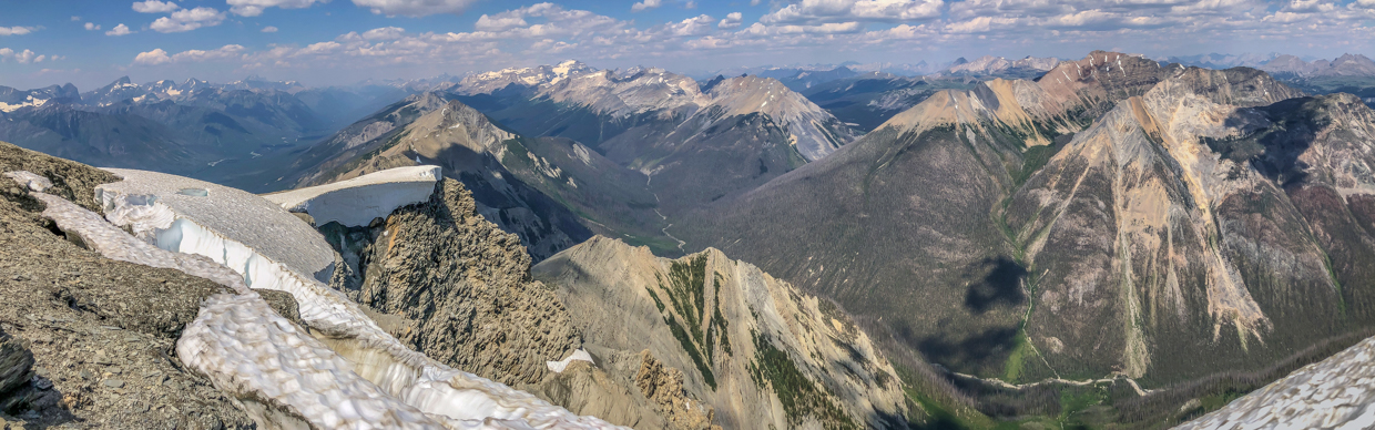
Thanks to its central Rockies location, Shanks’ northerly panorama was no less amazing than its southerly one. Click to see larger and try to spot Andrew being drawn to a cornice like a moth to a flame… 🦋🔥
.jpg)
Highway 93S follows the Vermilion Valley north along the base of Hawk Ridge (center right). In the distance, Mount Goodsir and Mount Vaux tower above Rockwall Peak (center left) as Kootenay NP gives way to its more northerly neighbor, Yoho NP.
.jpg)
A nearby cornice beckons: “Andrew, Andrew…” 🤣
.jpg)
Isabelle Peak (center middle ground) is a large mountain but it’s still dwarfed by the outliers of Mount Ball (center), Stanley Peak (center) and Deltaform Mountain (left) behind it!
.jpg)
You know a mountain is HUGE when its south face is heavily glaciated! Mount Ball is one such monster of a mountain. A little closer still, Haiduk Peak (right) used to be rarely ascended until a couple of new routes up it found their way onto the internet some years ago.
.jpg)
Panoramic views of the nearby Ball Range which rises up above fire-scorched Verdant Creek. Photo courtesy Andrew. Click to see larger.
.jpg)
Looking beyond the cornice towards Scarab Peak (left), Natalko Peak (center left) and the red-rocked Monarch (right).
.jpg)
Beyond the Monarch, familiar Banff National Park landmarks can be seen, including: Healy Pass and Peak (left), Pilot Mountain (center right in the shadow), Mount Brett (center right), Black Brett (center) and Mount Bourgeau (right).
.jpg)
To the east, a formidable wall of rock (Quartz Hill) rises up above the nascent Simpson River. Above this rock face, the scenic Sunshine Meadows sprawl from Banff National Park (left) into Assiniboine Provincial Park (right).
.jpg)
The scars of the Sunshine Village ski resort mar Eagle Mountain (left) and Mount Howard Douglas (right) at the northern end of the expansive Sunshine Meadows. In the distance, Cascade Mountain (left) and Mounts Inglismaldie and Girouard (right) can also be seen through the afternoon haze.
.jpg)
Further south along the Sunshine Meadows, Little Fatigue (center left) doesn’t look any smaller than Fatigue Mountain (center right) and both are much larger than Quartz Hill (left foreground) and Citadel Peak (right middle ground).
.jpg)
In the end, the views in this area always come back to massive Mount Assiniboine (which towers beyond Simpson Ridge, Nestor Peak, Indian Peak and Octopus Mountain)!
.jpg)
A final summit panorama featuring, essentially, the whole length of the Simpson River, Banff’s Sunshine Meadows, the Big A, and Kootenay’s Mitchell Range. Click to see larger.
.jpg)
Thanks to the random summit structures, Andrew and I were able to set up a pretty decent 10-second timer summit photo.
.jpg)
Speaking of summit structures, if you put a ladder on them, you’d better expect climbers to climb them… After all, the summit is the highest point, right? 🙃🤷 Photo courtesy Andrew.
.jpg)
🎵 On the Road Again… While it would have been nice to laze about for hours on the summit, we were, by now, up against our turnaround time. After 30 minutes of refueling our bodies and our souls (which Shanks had sapped), we begrudgingly started our long, but scenic, trek back along Shanks’ scrambly south ridge.
.jpg)
Pulling a “Matt Clay” and filling my hat with snow at every opportunity. With a very real likelihood of heat exhaustion, this cooling strategy (and over 5 L of water) proved amazingly effective and probably played a role in my not needing to be helicoptered off Shanks! Just watch out for “brain freeze!” Photo courtesy Andrew.
.jpg)
Down, down we go… Photo courtesy Andrew.
.jpg)
… Only to have to go back up again! 🤦 The long, undulating ridge walk was one of the factors that drew me to Shanks but the ups and downs added up in a very real way. Indeed, at 2,040 cumulative meters, Shanks was the biggest single day elevation gain of my peak-bagging career.
.jpg)
Enough is enough! Eventually, we grew weary about climbing up bumps on the ridge when we were supposed to be going down. Inspired by the goat we’d scared earlier, we therefore resigned ourselves to unpleasant (but effective) side-hilling. 😐
.jpg)
🎵 This is the ridge that never ends; yes, it goes on and on, my friend! 🐑 (Click to see larger)
.jpg)
Nearing the ridge’s south end, the haze over Assiniboine PP seemed to improve, granting the day’s clearest views towards the Matterhorn of the Rockies.
.jpg)
At long last, we reached the ridge’s terminus! Now, all that remained was the ultra-steep 1,100 m descent to the Simpson River below, followed by the 6.8 km hike out alongside said river. Easy, peezy, right?
.jpg)
A knee-jarring start to our descent on awful, blocky scree. 😣 Photo courtesy Andrew.
.jpg)
.jpg)
LEFT and RIGHT: Horrendous scree gradually gave way to grassy avalanche slope, however, the latter proved no more pleasant thanks to its stiff grade and the presence of random, unstable blocks of talus, hidden amidst the tall grass/fireweed. Also, did I mention that it was HOT? 🥵 Even Andrew (who seems to be perpetually happy), noted that this descent was absolutely terrible (albeit with a smile still on his face).
.jpg)
Of course, things got no less tedious as we maneuvered through, over and around endless burnt timber below the avy slope. Note that the omnipresent smile on Andrew’s face has suddenly gone missing… 🤣 Indeed, our assessment of the scramble at this point was a simple “Shanks but no Shanks!”
.jpg)
.jpg)
LEFT: At long last, we reached the trail (having succeeded at not accidentally or deliberately impaling ourselves on Shanks’ many tree spears). The reward for our substantive efforts? A near-7-km hike out during the day’s hottest hour. 🥳 As we plodded along, the contrast with our hike in was stark! Earlier, we’d chatted excitedly while soaking in the surrounding scenery. Now, we plodded rhythmically in near silence. Feeling nauseous from a combination of heat and exertion, I played mental games with myself, counting paces and shouting “Yo Bear” every 30 steps after Andrew had shouted likewise. I wasn’t sure what hurt more: my feet or my soul.
RIGHT: About halfway back to the car, we were blessed with a small stream crossing. As we drank from and immersed our heads in its cool, clear waters, I could literally feel my energy and will to live returning. Unfortunately, I also felt my sunglasses fall off my head and subsequently saw them disappear downstream. 😒🤦 This loss complimented the earlier loss of my bear spray (which now resides somewhere on Shanks’ south slopes). Some scrambles keep on giving but Shanks was clearly more of a taker!
.jpg)
Briefly energized by our half-hearted baths in the cool stream, we continued our plod out along the Simpson River trail with our now-nemesis, Mount Shanks, perpetually looming over us. This view of Shanks, in particular, serves to show just how long this scramble is! 🤯 Mouse over to see.
.jpg)
Nearing the trailhead, the return of Parks Canada’s interpretive signs was a welcome sign that the end was at hand! Unfortunately, by this point, delirium had already set in… 😵 “Look at me! I’m a jumping mouse! Teehee!” 🐭
.jpg)
.jpg)
LEFT: One painful step at a time, we eventually made our way back to the trailhead, returning 13.5 hours after we’d first set out. Exhausted, Andrew threw down his gear, took note of the many new tears in his pants and wondered "What the hell just happened?!" 🥺
RIGHT: Fully aware of the forecast heat 🌡️, I’d left a cooler with a couple of IPAs in the car. 🍻 Despite their labels which claimed they were “cold”, they proved anything but 🙃 (it seems my cooler is no match for a full day in the hot sun). Suffice to say, we enjoyed them nevertheless and joked about how sad the Crazy Pol Raf would be when he discovered that he’d missed out on Shanks and a “Mount Bryce” ale! 🤣 As we sat in the evening shade, we immersed our throbbing feet in the icy Vermilion River and renewed our spirits with piss-warm craft beer (while tourists pulled off the highway and literally took photos as they cartwheeled across the bridge). 🤸♀️🤨
Shanks was gruelling and it’s hard to say if I, at the time, enjoyed a single second of the 48,600 that I spent on it. Indeed, “Shanks for nothing” was another theme that Andrew and I joked about during our long day. As aches and pains faded with time, however, I found myself recalling Shanks in a more positive light. I’d been hoping for another “big day” and Shanks obviously delivered in terms of stats (28.5 km, 45,033 steps, 2,040 vertical meters, 7,522 calories burnt etc.) and scenery (Kootenay NP, Assiniboine PP, Yoho NP and Banff NP)! The more time that passes, the more I forget how awful this scramble was and the more that I convince myself that it was actually awesome. In the final analysis, Shanks ended up being classic type 2 fun and I find myself “Shankful” for a long day, filled to the brim with good company, wild terrain and amazing views.
.jpg)
.jpg)
.jpg)
.jpg)
.jpg)
.jpg)
.jpg)
.jpg)
.jpg)
.jpg)
.jpg)