GO FLAMES GO!!!
After a thrilling, come-from-behind, playoff series-clinching win by the Flames in game 6 the night prior, I decided to show my support for the team by climbing nearly 1,500 m above Canmore and shouting “Go Flames go!” from the summit of a lofty peak. Energized by the surprising performance of my hockey team, who were not even supposed to make the playoffs in 2015 (let alone advance beyond the first round), I decided that there was no scree slope too large or steep to keep the C of Red from being represented at altitude!
.jpg)
After foregoing the temptation to celebrate the Flames win late into the night on the Red Mile, I woke up early and made my way to Canmore. Despite heavy cloud cover on the drive out, I was pleasantly surprised to see relatively clear skies over Squaw’s Tit (left) and Mount Charles Stewart South (right) when I arrived. Parking near the drainage immediately south of the Cross Zee Ranch on Palliser Trail, I quickly encountered the crux of the ascent – locating “Johnny’s Trail” which is used for approach!
.jpg)
After failing to find “Johnny’s Trail” as described by Gillean Daffern, I eventually located it by meandering up the rocky drainage and sticking towards the left (north) bank. As you can see from this photo, many sections of “Johnny’s Trail” are just as rocky as the drainage itself!
.jpg)
After a couple of kilometers of rock-hopping, “Johnny’s Trail” actually starts to look like a trail; fortunately this is short-lived! Not far beyond this point, the trail intersects with the “Montane Traverse” trail and begins to ascend the left bank of the drainage. This was my cue to leave the cushy trail and resume my rock-hop up towards Stoneworks Canyon.
.jpg)
As the ascent drainage narrows and the walls to each side steepen, you eventually come to the entrance of Stoneworks Canyon.
.jpg)
Continuing upwards in the narrow confines of Stoneworks Canyon.
.jpg)
The canyon’s steep, smooth and sometimes overhanging walls proved a lovely diversion from the otherwise tedious dry creekbed. Alas, the canyon itself proved disappointingly short and I soon found myself back amongst more typical terrain.
.jpg)
After 90 minutes of dry creekbed hiking, my snowy objective (distant center) finally comes back into sight.
.jpg)
Not surprisingly, the ascent drainage is littered with evidence of somewhat recent landslides. I would guess that many of the larger such slides occurred during 2013’s historic flooding. Today, things seem a little more stable; still, the morning silence was frequently shattered by the clamor of pebbles falling, here and there, along the drainage’s steep banks.
.jpg)
Approaching the end of the dry creekbed. The open slope between the trees in the center marked the point at which I left the tedious rocky creek bed behind in order to take on the tedious scree-filled moonscape above! On the upside, by this point, I’d already gained over 600 m elevation.
.jpg)
Just above the creek bed, a tiny patch of alpine with a view back towards the Three Sisters provided a scenic snacking spot before continuing on with the slog. Between the canyon approach and scree bowl upper slopes, this little clearing was just about the only green that I got to see amidst a sea of gray rock all day!
.jpg)
Oh my – that’s quite a slog ahead of me…
.jpg)
Typical views while ascending the scree bowl.
.jpg)
The ramparts of Squaw’s Tit tower above, serving as an unpleasant reminder that the summit of Charles Stewart South is still 300 m above the highest point on these cliffs!
.jpg)
Mercifully, the mountain’s upper bowl was still filled with snow which provided a pleasant alternative to the scree bash below. The snow was still quite solid in the cool morning air and I was glad that I’d bothered to lug my crampons and axe up with me!
.jpg)
Typical views while sweating my way up the snow.
.jpg)
The summit of Squaw’s Tit, still above me, but less-so than before; an encouraging sign!
.jpg)
Thomas Edison said that “genius is 1% inspiration and 99% perspiration.” With inspiration running low and perspiration at an all-time high, I was forced to conclude that my idea to climb Charles Stewart South must have been genius!
.jpg)
As the slope steepened higher up, I became less and less comfortable on the snow, with its ever-increasing run-out distance in the event of a slip. Despite the pleasant nature of upward travel on solid snow, I therefore transitioned to murderously loose, steep scree which I knew would be safer but thoroughly unpleasant.
.jpg)
The upper scree slope was a pure suffer-fest, however, I soon found myself looking down upon the summit of Squaw’s Tit proving that I was, at the very least, making progress!
.jpg)
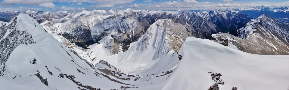
Upon reaching the ridge crest, the angle of the terrain finally eased and a spectacular panorama opened up back towards Canmore and the Bow Valley. After admiring the view (and more importantly catching my breath), I pressed onwards. Click to see larger.
.jpg)
The summit looks close but is still over 100 m above. Still, travel along the ridge crest (detouring to the climber’s left occasionally) was fast and pleasant compared to the slog below and I soon found myself kicking steps up the remains of the cornice guarding the summit of Charles Stewart South.
.jpg)
Not sure which I’m happier to see: the beautiful view unfolding to the north or the summit cairn?
.jpg)
Looking beyond my final steps up a small snow arête towards the wonderful panorama of the Canmore corridor and Bow Valley. From left to right: Mount Allan, Wind Mountain, Mount Lougheed, Mount Lady MacDonald (foreground), the Windtower, Rimwall Summit, the Three Sisters, Ship’s Prow, Mount Lawrence Grassi, Ha Ling Peak, EEOR, Squaw’s Tit (foreground), Mount Rundle, Cascade Mountain, Princess Margaret Mountain (foreground) and the (true) north summit of Mount Charles Stewart. Click to see larger.
.jpg)
A closer look at Mount Charles Stewart’s slightly higher north summit. Mount Peechee can be seen to the left while Mount Aylmer can be seen to the right.
.jpg)
Looking up the Bow Valley towards Banff.
.jpg)
Mount Norquay (left) and Cascade Mountain (right) can be seen along with a host of Banff area peaks beyond the pointy summit of Princess Margaret Mountain.
.jpg)
Mount Rundle towers over the Bow River below.
.jpg)
The town of Canmore lies beyond the summit nipple of Squaw’s Tit.
.jpg)
Ha Ling (left) and EEOR (right), separated by Whiteman’s Gap and Canmore’s colorful reservoir.
.jpg)
Proudly representing the C of Red at 2812 m! Go Flames go!!!
.jpg)
A snowy panorama of remote peaks beyond the summit cornice and a fresh avalanche below. From left to right: Poltergeist Peak, Mount Costigan, Stenton Peak, Mount Townsend, Mount Fable, Grotto Mountain and Mount Lady MacDonald. Click to see larger.
.jpg)
A closer look at Mount Costigan (left) and Stenton Peak (center) beyond the summit cairn.
.jpg)
Mount Townsend highlights the horizon on the center left while Mount Fable is the most prominent peak on the right.
.jpg)
The long ridge connecting Mount Fable (left) and Grotto Mountain (right).
.jpg)
Looking beyond Mount Fable towards distant Moose Mountain and the prairies to the east.
.jpg)
A closer look at Grotto Mountain’s impressive north face in front of a sea of Kananaskis Peaks including Skogan Peak (center left), Fisher Peak (center right) and Mount Collembola (right).
.jpg)
Mount Lougheed provides a scenic backdrop Mount Lady MacDonald. “Lady Mac” looks quite different from this angle.
.jpg)
A closer look at the four peaks of the Mount Lougheed massif and the much smaller Windtower (right).
.jpg)
Post card-worthy views of Canmore in the valley below.
.jpg)
A closer look at the iconic Three Sisters (Charity, Hope and Faith Peaks). Distant Mount Sir Douglas can be seen in the clouds just left of the Little Sister; Mount Birdwood is visible just left of the Middle Sister and the Big Sister is flanked by Mount Nestor (left) and Old Goat Mountain (right).
.jpg)
Shouting “Go Flames go!” for the entire town of Canmore to hear.
.jpg)
A plaque at the summit appears to be part of an effort to name Charles Stewart’s South peak “Buffalo Point.” With the exception of Vern Dewit, however, the name Buffalo Point does not seem to be catching on. Perhaps I should have hiked up with a plaque that read “Mount Go Flames Go!”?
.jpg)
After a lengthy photography break, I located the summit register and was pleased to discover that my ascent was the first of 2015!
.jpg)
Showing my team pride with a summit selfie before embarking on my descent.
.jpg)
Final spectacular views from up high along the summit ridge before beginning my steep scree and snow-assisted plunge back down to the valley below. Click to see larger.
.jpg)
Looking back at the upper mountain after a speedy 600 vertical meter descent. Although the snow field tempted me into a LONG and FAST glissade, it was much steeper than it looks near the top. I was solo and not completely confident in my ability to self-arrest at high speed, so I started the descent on scree before cautiously making my way onto snow lower down and then throwing caution to the wind and gleefully bum sliding down the lower snowfield with reckless abandon (mouse over for details)!
.jpg)
Picturesque views of the Three Sisters as the dry creek bed comes back into view below.
.jpg)
Miles of rubble between the car and I. To say that the hike out along the creek bed grew tedious would be putting it mildly…
.jpg)
The typical boulder-hopping view all the way down.
.jpg)
A brief respite from the dull creek in scenic Stoneworks Canyon.
.jpg)
Nearing the canyon’s exit, I readied myself for a final couple kilometers of rock-hopping. While this proved a dull end to the day, I amused myself by mentally replaying highlights from the previous night’s exciting hockey game. Win or lose in the next round of the playoffs, I couldn’t be prouder of the Calgary Flames and tedious finish or not, I couldn’t be happier with my day out on Charles Stewart South!
.jpg)
.jpg)
.jpg)
.jpg)